Endmoräne Tarbek
Das Bundesland Schleswig-Holstein verdankt seine Form und seine
landschaftliche Gestaltung zwei Eiszeiten. Es waren dies die
Saale-Eiszeit vor 200.000 bis 125.000 Jahren und die
Weichsel-Eiszeit vor 80.000 bis 15.000 Jahren.
Während die Eismassen der Saale-Eiszeit das Gebiet des heutigen
Schleswig-Holstein komplett überdeckten, rückte das Eis der
Weichsel-Eiszeit nur bis ungefähr zur Hälfte des Landes vor.
Somit wurde der westlich Teil des Landes von der Saale-Eiszeit
geprägt während der östliche Teil seine Ausformung durch die
Weichsel-Eiszeit erhielt.
Zwei wichtige Landschaftsformen nach einer Eiszeit sind die
Grundmoränen und die Endmoränen.
Bei N 54°03.405 – E 010°16.749 steht man auf einer
typischen Endmoräne.
Endmoränen kennzeichnen den Ort in der Landschaft, bis zu dem
die Eismassen in der Eiszeit vorgedrungen sind. Es sind die
Ablagerungen des Eises an der Stirn der Gletscherzungen.
Man unterscheidet zwei Arten von Endmoränen, nämlich
Satzendmoränen und Stauchendmoränen.
Eine Satzendmoräne entsteht, wenn über einen längeren Zeitraum
die Gletscherzunge nicht weiter voranschreitet, sondern ein
Gleichgewicht besteht zwischen Eisnachschub und dem Abschmelzen an
der Stirn der Gletscherzunge. Dies führte zu einer stationären
Eisrandlage, bei der immer neu herangeführter Gesteinsschutt aus
dem Eis herausschmolz und an der Stirn abgesetzt wurde.
Stauchenmoränen entstanden dann, wenn das vordringende Eis den
Boden, den es überdeckte, ausschürfte und vor sich herschob. Dieser
Vorgang ist durchaus mit der Arbeitsweise einer Planierraupe zu
vergleichen. Der Gletscher schob das Eis vor sich her, presste es
zusammen und in die Höhe und hinterließ dann bei seinem Abschmelzen
eine Stauchendmoräne.
Die Endmoräne bei Tarbek ist ca. 86 Meter hoch und trägt heute
den Namen Grimmelsberg.
Vom Kamm der Endmoräne aus hat man einen herrlichen Blick auf
die davorliegende typische Grundmoränenlandschaft (wellig, kuppig),
die den gesamten Osten des Landes prägt.
Doch nun zum Cache:
Wer diesen Cache loggen will, muß folgende Bedingungen
erfüllen:
1. Mache ein Foto mit dir oder deinem GPSr an dem Gebäude,
welches in unmittelbarer Nähe der Koordinaten steht. Sicher rechnet
niemand an dieser Stelle mit so einem Gebäude. Poste das Bild mit
deinem Log Dies ist keine Logbedingung, sondern nur eine Bitte).
ACHTUNG ! Das Gebäude ist kein Lost Place, es wird genutzt -
FINGER WEG !!
2. Beantworte folgende Fragen und sende die Antwort mit dem
Betreff „Tarbek“ an earthcaching@googlemail.com
:
a. Ist der Grimmelsberg eine Satzendmoräne oder eine
Stauchendmoräne?
b. Auf einer Seite einer Endmoräne findet man eine
Grundmoränenlandschaft, welche Landschaftsform der glazialen Serie
findet man auf der anderen Seite?
Bitte nicht mehr als 3 bis 4 Worte pro Antwort, eigentlich reicht
eins.
Du kannst den Cache loggen, wenn du dein Bild mit dem Log
postest. Eine Logerlaubnis braucht du nicht abzuwarten.Deine
Antworten per Mail werde ich prüfen und dich informieren, wenn sie
falsch sind.
Viel Spaß!
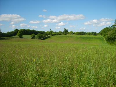

Die nahe Grundmoränenlanschaft - The nearby ground
moraines
Terminal moraine Tarbek
The federal state Schleswig - Holstein owes his form and his
regional creation to two ice ages. These were they the hall ice age
200,000 to 125,000 years ago and the Vistula ice age 80,000 to
15,000 years ago.
While the masses of ice of the hall ice age covered the area of
today's Schleswig - Holstein completely, moved forward the ice of
the Vistula only to the about country half of it. Therefore the
part to the west of the country was stamped by the hall ice age
during the eastern part his form by the Vistula ice age
received.
The most important scenery forms after an ice age are the ground
moraines, the terminal moraines and the outwash plains.
With N 54°03.405 - E 010°16.749 one stands on a typical terminal
moraine.
Terminal moraines mark the place in the scenery up to which the
masses of ice have penetrated in the ice age. These are the
depositions of the ice in the forehead of the glacier tongues. One
distinguishes two kinds of terminal moraines, namely sentence
terminal moraines and pressed terminal moraines.
A sentence terminal moraine originates if for a longer period
the glacier tongue progresses not further, but a balance exists
between ice supplies and melting in the forehead of the glacier
tongue. This led to a stationary ice edge situation with which
advanced rock rubble from the ice melted out and in the forehead
was set down always anew.
Pressed terminal moraines originated when the penetrating ice
moved over the ground which it covered scraped out and dozed before
itself. This process is absolutely to be compared to the approach
of a bulldozer. The glacier moved over the stone before itself,
pressed together it and upwards and then left with his melting a
pressed terminal moraine.
The terminal moraine with Tarbek is approx. 86 metres high and
today bears the name Grimmelsberg (Mount Grimmel).
From the comb of the terminal moraine one has a marvellous look
at the typical ground moraine scenery (wavy) which stamps of the
whole east of the country.
However, now to Cache:
Who wants to log these Cache, must fulfil the following
conditions:
1. Make a photo with you or your GPSr in front of the building
which stands in immediate nearness of the co-ordinates. Certainly
counts no one at this point to such a building. Post the picture
with your log This is no condition, just optional). PLEASE NOTE
: The building is no Lost Place, it is still in use - HANDS OFF
!!
2. Answers the following questions and sends the answer with the
reference "Tarbek" to earthcaching@googlemail.com :
a. The Mount Grimmel (Grimmelsberg) is a sentence terminal
moraine or a pressed terminal moraine?
b. On a side of a terminal moraine one finds a ground moraine
scenery, which scenery form of the glacial series does one find on
the other side?
You can log the cache directly if you post your picture with your
log. Dont wait for a log-permission, if your answers are wrong, I
will inform you.
A lot of fun!