Long Point Fault Earthcache EarthCache
Long Point Fault Earthcache
-
Difficulty:
-

-
Terrain:
-

Size:  (not chosen)
Please note Use of geocaching.com services is subject to the terms and conditions
in our disclaimer.
Upon arrival at the posted coordinates, you’ll find a sign that says BUMP, but this isn’t just any bump in the road, this is the Long Point Fault!
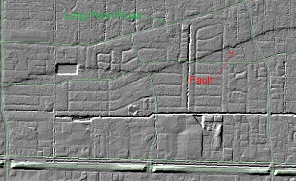
The Long Point Fault has one of the largest drops or "scarps" in the Houston area. For an area as flat as the Gulf Coast, this altitude change is significant, and damages nearly every road, pipeline, and building unfortunate enough to be built across it. Movement rates can be as high as 1-2 cm/year. The Long Point Fault can be distinctly seen in this LIDAR DEM (LIght Detection And Ranging Digital Elevation Model) image from the 2002 Tropical Storm Allison Recovery Project.
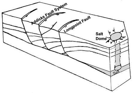
Houston’s geology developed from stream deposits left by the erosion of the Rocky Mountains. These sediments consist of unconsolidated clays, clay shales, and poorly-cemented sands extending to depths of several miles. These deposits were layered on top of decaying organic matter that, over time, became oil and natural gas. Beneath all of this is a water-deposited layer of rock salt. As the layers were compressed and forced upward, the salt dragged surrounding sediments into dome shapes, usually trapping oil and gas that seeped in from any surrounding porous sands. Most of the area’s faults are related to the movement of these salt domes.
 Some blame this movement on ground water, oil, or gas withdrawal, but the Long Point Fault is present on topographical maps from the 1910s, prior to major fluid removal, so most geologists believe that the motion is not caused by humans. In fact, there is some evidence that these faults were moving in prehistoric times.
Generally, faults in this area run parallel to the coast and result from the slow slump of the land towards the Gulf. These faults move only very gradually in what is termed “fault creep.” The thick layers of clay sediment do not build up friction, which would produce the ground shaking in an earthquake, so Houston is tremor-free. This is fortunate, since there are 86 mapped and historically active surface faults with an aggregate length of 149 miles!

To log this Earthcache, become a GPSr Geologist! Use the power of your GPSr to estimate the altitude drop of the Long Point Fault. Now a GPSr Geologist is always thorough, so you’ll need to travel to multiple sites along the scarp to investigate.
1. Use your GPSr to measure the altitude change that occurs as you travel north from the BUMP sign (posted coordinates) and cross the scarp. Estimate to the nearest foot.
2. Waypoints A through D are all locations along the fault. Visit each and determine which of the four has the fault cross the road diagonally.
3. The fault is also visible at Waypoint E, but not as damage to the street. Describe how the residents on the north side of the road have handled the fault.
4. You are welcome to log your find, but MUST email your answers to my geocaching email, do not post them here! If I do not receive this email within a week of your log, I WILL DELETE your find!
References
Mapping Active Faults in the Houston Area Using LIDAR, Richard Engelkemeir et al.
Principal Active Faults in Harris County, Texas, Harris County Flood Control District
Houston Geographic Description
| I have earned GSA's highest level: |
 |
Additional Hints
(No hints available.)