A beautiful beach with a colourful history; Botanical Beach teems with marine life, and is surrounded by coastal rain forest.
Three archaeological sites within the park suggest that the area was used for shark-fishing camps by First Nations people. The oil extracted from the shark’s liver was used in trade with the Hudson’s Bay Company.
The first marine research station in the Pacific Northwest was established here in 1901 by the University of Minnesota. Initially, two buildings were constructed. Later a two-storey botany laboratory was added. The buildings provided accommodation for as many as 80 researchers. Students and researchers came from all over the world to study. To get to the station, a steamship would come from Victoria to Port Renfrew. From there it was on foot on a very muddy and narrow trail to the research station. A better road in was promised, however, it never materialized.
 Professor Conway MacMillan, state botanist of Minnesota, and Dr. Josephine Tilden, were the main force behind the research station, even funding its operation from their own salaries. The abundance of life was what drew Dr. Tildon to choose Botanical Beach. A new kelp was discovered here in 1905 and was named Renfrewia Parvula, but it now is known as Laminaria Ephemera. In 1906, the station was closed because the University of Minnesota would not support a research program outside the USA.
During World War II, the Canadian military used the park area for defence of the coast. Remnants of a plank road, constructed to provide access to a gun emplacement, are still evident.
Large portions of the park were logged in the early 1960s. In 1987 another 10 hectares were logged.
In February of 1989 Botanical Beach was established as a Class ‘A’ Provincial Park, the highest level of protection.
The area continues to be the subject of research by institutions such as the University of British Columbia and the University of Victoria.
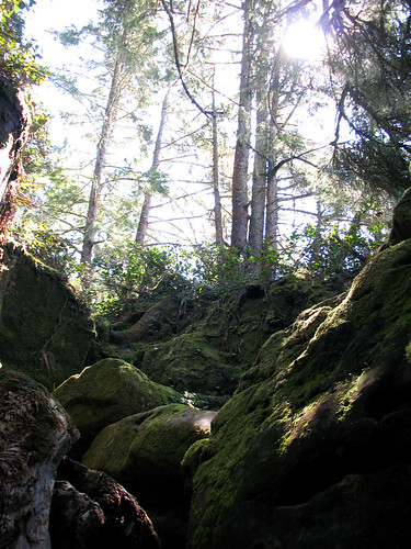 Coastal Rainforest
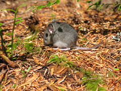
While walking along the Botany Bay/Botanical Beach Loop Trail you will pass stands of old-growth western hemlock. Numerous species of birds can be seen about the dense rainforest canopy. Try not to step on the abundance of slugs on the trail. While you’re looking down, keep an eye out for centipedes and deer mice. You might even spot deer in the underbrush.
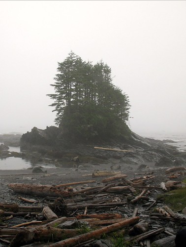 Rock Formation and Sea Stacks
The rocks of the Pacific Rim are believed to have originated in the area where you would now find the San Juan Islands. They were the product of large submarine landslides. They moved to their present location about fifty-five million years ago.
The principal rock formations of the area are shale, conglomerate, and sandstone. The shale lies at the bottom. Shale rock is a type of sedimentary rock formed from clay. Conglomerate overlies the shale. Conglomerate rocks are sedimentary rocks. They are made up of large sediments like sand and pebbles that are compacted together by pressure. Sandstone overlies the conglomerate.
At Botany Bay the rocks are tilted, exposing the different layers. The softer rock gets washed away faster by the waves. In places this leaves small tidal islands of harder rock. When an island has particularly steep sides, it is known as a sea stack.
Extensive sandstone flats are found at Botanical Beach. This is where you’ll find the most magnificent tide pools.
Caves and bowls carved by waves
If the tide is low enough you can walk from Botany Bay to Botanical Beach along the shore. Here you will find high, steep cliffs. During storms the waves hammer these cliffs slowly carving out large bowls and caves.
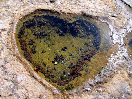
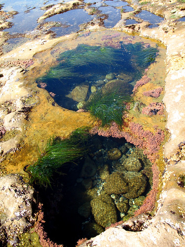 Tide Pools
The tide pools were created by large hard rocks being tossed by the waves on the softer sandstone. Slowly the rocks wore holes in the sandstone. Sea urchins further enlarged these holes making little hollows to protect themselves from the surf.
Tidal Zones from shallow to deep
Spray Zone: This zone gets spray from waves during high tides and storms. At other times the rocks bake in the sun, or suffer cold winds. Only a few organisms can survive such harsh conditions. Lichens and barnacles live in this region. Barnacles are well adapted against water loss. Their calcite shells are impermeable, and they possess two plates which they can slide across their aperture when not feeding. These plates also protect them from predators.
High and Mid Tide Zone: The high tide zone is flooded for only a few hours each day during high tide. The organisms there must survive wave action, currents, and exposure to the sun. The high tide zone is inhabited by sea anemones, sea stars, chitons, crabs, green algae, and mussels. Algae also provide shelter for organisms such as hermit crabs. The waves and currents, which make life in the high tide zone difficult, bring in food to filter feeders and other tide pool animals.
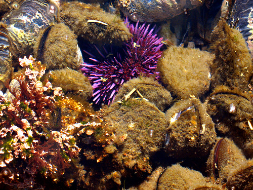 Low Tide Zone: This area is exposed only at very low tide. It is teeming with life; the most notable difference in this zone compared to the other three is that there is much more marine vegetation. There is also great biodiversity. Organisms in this zone generally are not well adapted to periods of dryness and temperature extremes. Some of the organisms in this area are anemones, brown seaweed, chitons, crabs, green algae, limpets, mussels, sculpin, sea palms, sea stars, sea urchins, shrimp, snails, sponges, surf grass, tube worms, and whelks. In this zone, the water is shallow enough to allow plenty of light to reach vegetation, and the salinity is at almost normal levels. This area is also protected from large predators because of wave action and the shallowness of the water. This allows creatures in this area to grow to larger sizes.
Tides:
Low tide is the best time for viewing the tide pools (1.2m or less). Use the Tide Tables for Port Renfrew to plan your visit.
To Log This Cache:
Part A:
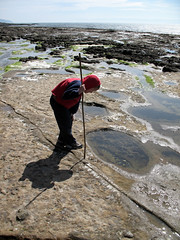
Photograph and identify at least one plant or animal living in a tide pool.
Photograph layered rock near Botany Bay.
Photograph a Sea Stack
Post these photos to the cache page.
If you’re not camera shy, we’d like to see you in one of the above photos.
Part B:
Read the interpretive signs along the Botany Bay/Botanical Beach Loop Trail. From these signs, the answers to the following questions:
1. How much precipitation does this area receive per year?
2. Lichen is a partnership between what two types of plants?
3. Vancouver Island is the only place in Canada where you can see what type of animal?
4. The Extremely harsh environment here causes what type of tree?
5. What type of home has mysteriously disappeared?
 Take nothing but photographs, leave nothing but footprints.
Please show this area the respect it deserves. Stay on marked trails. Watch your feet! Barnacles and sea grass may be exposed and dry at low tides but they are alive and most likely won’t survive being stepped on. DO NOT place anything in the tide pools. It may be tempting to use your underwater camera but this would contaminate the tide pool. It will be several hours before these pools receive clean water from the ocean. Sunscreen is especially toxic and some animals are even sensitive to the oils on your skin. Look, don’t touch. Pack out all of your garbage. Help us preserve this special place so it can be enjoyed for generations to come.
This cache was placed for the BCGA Blitz 2009. Thanks to all those who participated.