
 This area is only open during the summer season since Tioga Pass is not plowed during the winter.
The closest parking for the dome is in the turnout along the Highway, however there is not room for many cars. Parking anywhere in Tuolumne Meadows and taking one of the many trails to the dome gives you the opportunity to enjoy the meadow it self. In either case, use existing trails around the edge of the meadow so as to preserve the ecology of the meadow.
The Tuolumne Valley was carved out of the mountains by a series of glaciers. Examples of typical glacial erosional features such as glacial polish and glacial erratics can be found on Pothole Dome. The geomorphology of Pothole Dome is also a typical example roche moutonnee, a landform formed by glaciers. For more information on glaciers see the University of Kentucky glacier webpage. It does require flash.
Glacial Polish – N37 52.882 W119 23.541
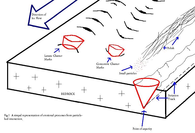
While the glaciers flowed through the valley, pressure of 1,000 to 2,000 feet of ice and small bits of rock moving over the granite gradually ground it down and polished the surface. The process is similar to a rock tumbler. Glacial polish only exists on the outer surface of the rock, so it gets eroded away relatively quickly. Patches of glacial polish of various sizes exist on Pothole Dome. They are most easily identified by their reflective surface.
 Striations - N37 52.861 W119 23.584
Striations are created similarly to glacial polish, but by slightly larger rocks dragged along the top of the bedrock by the moving glacier. These larger pieces create scratches in the surface of the polish similar to a grain of sand that is dragged across a mirror. On Pothole Dome, the striations are visible as just a haze with barely discernable linear features in the polish. The direction of the line shows the direction of the glacier’s flow.
Chatter Marks- N37 52.734 W119 23.626
Chatter marks are another variation of marks left by rocks dragged across the top of the bedrock by a glacier. Where continuous scraping of material across the bedrock forms polish and striations, chatter marks are formed by a slight bouncing of a larger rock against the bedrock. This slight bouncing gouges out series of small crescents in the bedrock.
 Glacial Erratics – N37 52.813 W119 23.607
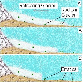
Two characteristics largely define a glacial erratic. First is that it must be transported a significant distance by a glacier or iceberg. And second, the erratic is typically a different rock than the surrounding rock that it is deposited on. Size does not define an erratic. While shape does not define an erratic, they are often very round because the rough edges are eroded off while the erratic is being transported within the ice.
A glacier erodes large rocks and boulders and incorprates them into ice. As the glacier moves, the rocks and boulders move with it. When the glacier retreats, the ice melts leaving the boulder behind, a glacial erratic.
There are large erratics scattered across the top of Pothole Dome. These erratics are round and appear to have been just dropped on top of the dome. While the erratics may look like the same granite that makes up the dome they sit on, violating the second characteristic of erratics, they are actually a different type of granite. Geologists have identified a variety of granites throughout Yosemite National Park based on the composition of the individual minerals, size of the crystals, and age of the rock.
 Roche Moutonnee – Same as Stiations
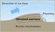
A roche montonnee is an asymmetrical hill that has a gently sloped smooth side and a steep rough side. A glacier flowing over a resistant outcrop of rock creates this landform. As the glacier rides up the rock, there is added pressure on the ice against the rock and a portion of it melts. As the glacier goes down the other side of the outcrop, the pressure is released allowing the water to refreeze in the cracks of the outcrop. The freezing water expands in these cracks wedging off pieces of the outcrop in a process called plucking. This results in the smooth upstream side of the dome and the sheer downstream side of a roche montonnee.
While on Pothole Dome you can see (and probably climbed) the gentle upstream side and can see where the slope of the dome gets steep on the downstream side.
In addition to these typical glacial features, Pothole Dome also has features that are characteristic of turbulent fast-flowing rivers called potholes and flutes.
 Potholes – N37 52.695 W119 23.665
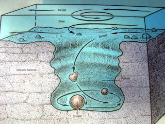
Potholes form where a rock (or many rocks) is spun around in the same spot by circular eddy of water. The constant abrasion begins to wear away the bedrock into a hole. Once started, the feature is self-reinforcing as the hole creates an even stronger eddy. The rock being spun in the hole is called a grinder and as one grinder wears away another rolls in to fill its place.
On Pothole dome the potholes are feet across. These potholes actually are thought to have been created beneath the glacier by water that melted on the surface of the glacier, fell down vertical shafts called moulins and then flowed underneath the glacier.
Flutes – N37 52.698 W119 23.673
Flutes are wavy smooth channels ground into the bedrock by fast flowing water. These form by the erosion of the bedrock by the unending grinding of suspended particles against the bedrock. Overtime, the surface of the bedrock looks similar to glacial polish, however glacial polish is formed on flat surfaces while the polish in flutes is on curved surfaces.
As with the potholes, the water source for these flutes was the water that fell down the moulins to form rivers beneath the glacier. Because of the water pressure from the water coming down the moulin, it is thought that the rivers beneath the glacier were actually flowing up the face of the dome.
Logging requirements:
Send me a note with :
- The text "GC1QN2J Pothole Dome - Glacial Features" on the first line
- The number of people in your group.
- Find a location on the dome with glacial polish and try to determine the direction of flow based on the striations.
- Have a close look at the erratics and see if you can see a difference between the granite of the erratic and that of the dome.
- Look east toward Lambert Dome. Is it a roche montonnee and why?
- About how wide and deep are the potholes? What has happened to the potholes?
The above information was compiled from the following sources:
- Johnson, Robin C. and Dod Lofstrom, Geology Trails of Northern California, Gems Guides Book Co, Baldwin Park, Ca
- Jennifer Mikolajczyk , University of Wisconsin at Eau Claire, Interstate Park, http://www.uwec.edu/jolhm/Interstate2006/potholes.htm
- NPS Literature
- http://libwiki.mcmaster.ca/clip/index.php/Main/FORMATION
- Thomas Juon and Dak Helentjaris, Last modified May 17, 1999, http://gemini.oscs.montana.edu/~geol445/hyperglac/eroproc1/
Trial listing approved by
Yosemite National Park