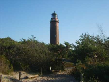
Leuchtturm / Lighthouse
Darsser Ort
Ausgleichsküste – Strandhaken – Nehrung –
Haff
Hier am Darsser Ort und in der Umgebung kann man die Wirkung von
Wind und Wasser auf die Küstenlinie gut erkennen. Die nördlichste
Landzunge der Halbinsel Fischland-Darss-Zingst ist der Darsser
Ort.
Der Darsser Ort liegt an der Ostsee, in Mecklenburg-Vorpommern,
im Nordosten der Bundesrepublik Deutschland. Der Darsser Ort ist
durch Sandablagerungen entstanden.
Diese Ablagerungen und die dadurch entstehenden Küstenformen
sind typisch für eine so genannte Ausgleichsküste. Das typische
einer Ausgleichsküste ist eine flache und gerade Küstenlinie ohne
große Einbuchtungen und Vorsprünge.
Durch den Einfluss von Wind und Wellen werden im Laufe der Zeit
Vorsprünge abgetragen und Einbuchtungen aufgefüllt, so das eine
gerade Küstenlinie entsteht. Eine Ausgleichsküste kann nur dann
entstehen, wenn Wind und Strömung fast ganzjährig in einer Richtung
auf die Küste einwirken. Dabei muß die Windrichtung küstenparallel
sein oder der Wind muß im spitzen Winkel auf die Küste treffen. Die
Hauptströmungsrichtung muß parallel zu Küste verlaufen. Am Darsser
Ort ist dies der Fall und zwar herrschen hier ganzjährig Wind- und
Strömungsrichtungen von West nach Ost vor. Hierbei wird Sand und
Geröll langsam aber sicher von West nach Ost bewegt. Der Transport
der Sand- und Sedimentteilchen geschieht dann auf folgende
Weise:
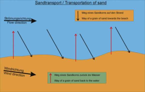
Wenn eine Welle auf den Strand trifft, dann läuft sie schräg in
Wind und Strömungsrichtung auf den Strand auf. Dabei transportiert
sie etwas Sand schräg den Strand hinauf. Wenn die Welle nun
zurückflutet, dann fließt sie nicht schräg in offene Wasser zurück,
sondern immer im rechten Winkel zur Küste. Widerum wird etwas Sand
mitgenommen. Die nächste Welle nimmt den Sand wieder schräg nach
vorn auf den Strand mit, von wo aus er dann wieder rechtwinklig in
Meer zurückgespült wird. Auf diese Weise werden Sand und Sediment
längs zur Küste fortbewegt.
Hier am Darsser Ort kommt es aber zu einer Besonderheit der
Ausgleichsküste. Man beobachtet hier die Bildung eines
Strandhakens. Wenn im Verlaufe der Küste eine Bucht zu groß ist
oder die Küstenlinie eine größere Biegung macht, wird der
Sandtransport verlangsamt und Sand und Sediment werden abgelagert.
Es bilden sich Ablagerungen, die ins Meer oder die Bucht
hineinragen. Diese Strandhaken können können mit erstaunlicher
Geschwindigkeit wachsen.
Wenn ein Strandhaken das andere Ende der Bucht erreicht, die
Bucht also komplett oder bis auf einen schmalen Durchlass vom Meer
abschnürt, spricht man von einer Nehrung. Bekannte Beispiele
hierfür an der Ostseeküste sind z. B. die Frische Nehrung und die
Kurische Nehrung.

Der Darsser Ort ist heute Teil des Nationalparks Vorpommersche
Boddenlandschaft. Er kann nicht mit Kraftfahrzeugen, sondern nur zu
Fuß, mit dem Fahrrad oder mit Pferdekutschen erreicht werden. Einen
herrlichen Ausblick auf die Landschaft hat man vom Leuchtturm
Darsser Ort. Auf dem Weg zum Leuchtturm durchquert man den
„Darsser Urwald“, ein wunderschönes Waldgebiet.

Strand / Beach
Darsser Ort
Balance coast - beach hook - bay bar - lagoon
Here at Darsser Ort and in the surroundings one can recognise
the effect from wind and water on the coastal line well. The most
northern land tongue of the peninsula Fischland-Darss-Zingst is the
Darsser Ort. The Darsser Ort lies on the Baltic Sea, in
Mecklenburg-West Pomerania, in the north-east of the Federal
Republic of Germany.
The Darsser Ort has originated from sandy depositions. These
depositions and the coastal forms originating from it are typical
for a so-called balance coast. The typical one of a balance coast
is a level and just coastal line without big indentations and
Projections. Projections are used in the course of the time by the
influence of wind and waves and are filled in projections, thus one
just coastal line originates. A balance coast can originate only if
wind and current have an effect almost all year round in a
direction on the coast. Besides, the wind direction must be
coastal-parallel or the wind must hit in the sharp corner on the
coast.
The main current direction must run in parallel with coast. In
case of Darsser Ort this is the case namely all year round wind and
current directions of west after the east rule here. On this
occasion, sand and stone is moved slowly indeed by west after the
east. Then the transport of the sandy particles and sediment
particles happens in the following manner: If a waving on the beach
hits, it accumulates at an angle in wind and current direction on
the beach. Besides, she transports some sand at an angle the beach
up. If the wave now flows back, does not flow back then they at an
angle in open waters, but always in the right corner to the coast.
Again is taken some sand. The next wave takes the sand again at an
angle forwards on the beach, then from where he becomes flowing
back again at right angles in sea. In this manner sand and sediment
are moved along to the coast.
However, here at the Darsser place it comes to a specific
feature of the balance coast. One observes here the education of a
beach hook. If in the course of the coast a bay is too big or makes
the coastal line a bigger bend, the sandy transport is slowed down
and sand and sediment are deposited. There form depositions,lieing
in the sea or the bay. These beach hooks can be able at astonishing
speed grow.
If a beach hook reaches the other end of the bay which cuts off
bay completely or up to a narrow passage of the sea, one speaks of
a bay bar. Today the Darrser Ort is a part of the National Park
Vorpommersche Boddenlandschaft. He can be reached not by
automobiles, but only on foot, by the bicycle or with horse
carriages. One has a marvellous view of the scenery of the
lighthouse Darsser Ort.
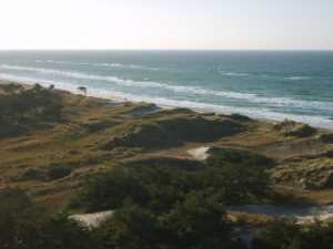
Blick vom Leuchtturm / View from lighthouse
Doch nun zum Cache:
Wer diesen Cache loggen möchte, muß folgende Bedingungen
erfüllen:
1. Mache ein Bild von dir oder deinem GPSr vor dem Leuchtturm
Darsser Ort (Im Log posten, dies ist keine Logbedingung, sondern
eine Bitte)
2. Beantworte folgende Fragen:
a.) In welcher Form wird das durch Wind und Wellen
herantransportierte Material am Darsser Ort angelagert?
b.) Welche Baumart wächst am Darsser Ort hauptsächlich?
c.) Wieviele Meter „wächst“ der Darsser Ort pro Jahr
duchschnittlich?
Du kannst den Cache direkt loggen, wenn du das Bild mit deinem
Log postest. Eine Logerlaubnis brauchst du nicht abzuwarten.Die
Antworten auf die Fragen bitte gleichzeitig an
earthcaching@googlemail.com mailen.Falls die Antworten falsch sind,
werde ich mich melden.
However, now to the Cache:
Who would like to log these Cache, must fulfil the following
conditions:
1. Make a picture of you or your GPSr in front of the lighthouse
Darsser Ort (post it in the log, no condition, just optional )
2. Answer the following questions:
a.) In which form this is taken up by wind and waves brought
material at the Darsser Ort?
b.) Which type of tree grows at the Darsser Ort primarily?
c.) How many metres "grows" the Darsser Ort per year
averaged?
You can log the cache directly if you post your picture with the
log. Mail the answers to: earthcaching@googlemail.com. Dont wait
for a log-permission. If your answers are wrong, I will inform
you.