'Iao Needle (Volcanic/Basalt & Erosion) EarthCache
'Iao Needle (Volcanic/Basalt & Erosion)
-
Difficulty:
-

-
Terrain:
-

Size:  (other)
Please note Use of geocaching.com services is subject to the terms and conditions
in our disclaimer.
Mahalo for visiting Maui, the island where I was born. This cache requires driving to a parking area and walking around 300-400 yards to the viewing shelter.
”Iao Needle”
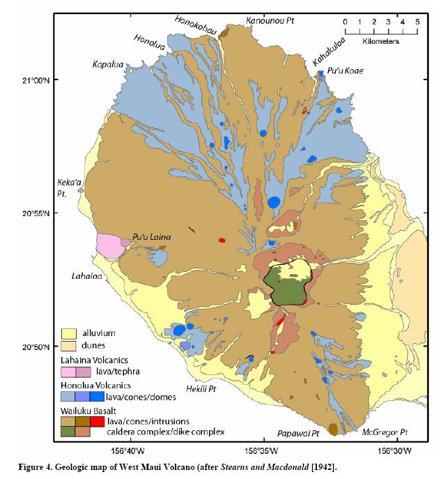
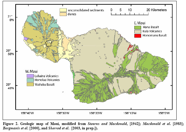
Maui is comprised up of two volcanic systems with an exposed valley in between. West Maui includes the Lahaina Volcanics, Honolua Volcanics, and the Wailuku Basalt. East Maui is comprised up of Hana Basalts, Kaula Volcanics, and a little bit of Honomanu Basalts.
Basalts as defined by Wikipedia and Encyclopedia Britannica as: “extrusive igneous volcanic rock that is low in silica content, dark in colour, and comparatively rich in iron and magnesium. It is usually grey to black and fine-grained due to rapid cooling of lava at the surface of a planet. It may be porphyritic containing larger crystals in a fine matrix, or vesicular, or frothy scoria. Unweathered basalt is black or grey.”
The ‘Iao Needle is situated near the intersection of ‘Iao Stream and Black Gorge, and you are now inside the remnant of the old West Maui caldera. ‘Iao Valley is a spectacular, amphitheater-headed valley that roughly marks the old caldera, enlarged by erosion. An excellent view of ‘Iao needle can be obtained from the shelter. The needle is actually a narrow ridge viewed head-on. It is an erosional remnant of Wailuku basalt flows cut (and probably supported) by dikes. ‘Iao in Hawaiian means supreme point or reaching (to the) sky. A large boss is exposed in the east wall of Black Gorge. The discordance between south-dipping talus breccias and northeast-dipping lava flows is evident when looking east from the observation shelter. Several dikes are exposed on the south wall of ‘Iao Valley. PLEASE check ahead of the time if the park is open as they will close it for bad weather, maintenance, etc. (don't get mad at me if you can't get into the park or log that Owner needs maintenance).
Rift zones of Maui as defined by the distribution of cones and dikes of the West Maui volcanic series. West Maui has undergone profound erosion mostly by water and streams. Broad alluvial fans are distinct along the eastern and southwestern side of the mountain.
To get credit, please upload the picture and email me the following (don't be upset if I don't respond...keep going):
1. Take a picture of you with the GPS and the needle ‘Iao needle behind you.
2. Estimate how deep is the Black Gorge down to the ‘Iao Valley.
3. What color is most of the Wailuku basalt rocks in this area and estimate how wide are the streams currently that generate most of the erosion around the basalt structures?
4. Extra Credit: Upload pictures of evidence of basalt, dikes/vents, and “caldera”.
If you are into Geology and not just logging in another Earthcache, I highly recommend downloading the "Maui Field Trip" guide by John Sinton / University of Hawaii / Dept. of Geology and Geophysics from Maui Field Trip Guide (<== press link) and researching Stearns and Macdonald - 1942, Bergmanis, Diller, or Sherrod.
Below are examples of what may be learned from this field guide:
Structure and Geologic History of West Maui Volcano - West Maui volcano is an asymmetric dome, elongated NW-SE. Stearns and Macdonald [1942] mapped a central caldera, roughly coinciding with ‘Iao Valley. Lava flows dip outward from the caldera region at angles of 10-20°, somewhat steeper than is typical for most Hawaiian shield volcanoes. Although a few faults not associated with the caldera are locally exposed, such faulting is of limited extent and insignificant to the development of the volcano. Stearns and Macdonald [1942] identified two rift zones, extending NW and SE from the caldera region, and Macdonald and Abbott [1970] suggested the existence of a third rift zone extending NE from the caldera. The NW and SE rift zones are defined by an abundance of basaltic dikes striking parallel to those zones and by the overall morphology of the edifice. The NE rift zone marks the location of Honolua dikes and vents that are distributed in two broad, cone-shaped regions radiating generally to the NE and SW of the caldera.
The shield stage of West Maui is represented by the Wailuku Basalt, mainly consisting of thin-bedded pahoehoe flows comprising more than 90% of the subaerial shield. ‘A‘a flows and discontinuous beds of vitric tuff are dispersed throughout the exposed section, but become increasingly common in the later stages of shield activity. Lowermost Wailuku Basalts are aphyric to moderately olivine-phyric tholeiitic basalts. Total phenocrysts and the relative proportions of plagioclase and clinopyroxene as phenocryst phases increase in the uppermost Wailuku flows. Diller [1982] identified a ~50 m-thick Upper Member of the Wailuku Basalt, based mainly on phenocryst assemblages. The upper member has larger and more abundant olivine and plagioclase phenocrysts, accompanied by an increasing proportion of clinopyroxene phenocrysts greater than 1 mm in size.

Additional Hints
(Decrypt)
Qba'g jbeel vs V qba'g rznvy onpx nf V trg gbaf bs rznvyf. Rawbl naljnlf. Naq gb fbzr bs lbh jub jevgr gb zr gb fgngr gung vg arrqf znvagranapr be gurl pna'g svaq vg....vg vf na RneguPnpur...yby...gur TCF whfg trgf lbh gb na nern.