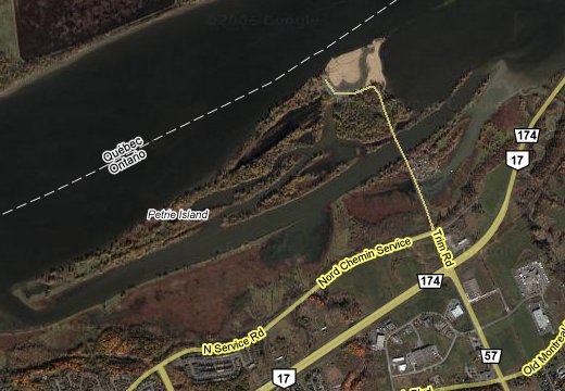
Petrie Islands
Approximately 798 acres in size, the Petrie Islands are a series of alluvial deposits forming a wetland complex of elongate sedimentary ridges and backwaters characteristic of the Ottawa River below the confluence with the Gatineau River. Along with Kettle Island and the Duck Islands, Petrie Islands form a unique landform in the region chronicling the powerful geological forces which shaped the face of our country. The sand and clay sediments that make up these islands were created by the massive icesheet that ground and polished the continent 10,000 years ago. Crushed by the continental glaciers from the rocks further north, the sediments were carried down the Ottawa and Gatineau Rivers. The river became a major route for plants and animals moving into Canada after the glaciation. Fine sediments would have provided the closest thing to soil available on the denuded landscape. From the patterns of plant distribution we can still see the effects of these processes today. The unique habitats of the river corridor contain many plant species which reached their migrational limits along the floodplain forests and shores. Many species of plants can only be found in the region along the floodplain of the Ottawa River. Some of these plants require water systems and flooding for their seeds to be dispersed. Some need the continual shifting of shoreline sediments, while others need their habitat to be inundated in the spring but dried out in the fall. All of the plant communities found on the Petrie Islands are specially adapted to extensive spring flooding. The power of the river and its seasonal fluctuations have shaped these islands and made them a special habitat for plants and animals.
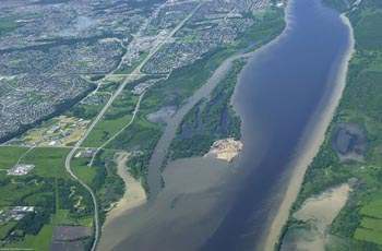
The islands are almost completely flooded in the spring, a special feature that many species are adapted to and may even require to maintain healthy populations. Continual erosion and deposition of sediments around the islands provides a renewal of shoreline habitats and an evolution of plant and animal communities. The quiet backwaters are extremely rich habitats providing shelter and abundant nutrients for a wide variety of plants and animals not found in the open river. The diverse mosaic of habitats, high-energy river shores, seasonally flooded forests, quiet backwaters, sand dunes, fertile clay soils, are all formed from the same processes, unique in the region to the Ottawa River. It is this variety of habitat that supports the many plants and animals of Petrie Islands. At one time the types of habitats and communities found on Kettle Island, the Duck Islands and Petrie Islands would have been common along much of the Ottawa River shores between Ottawa and Montreal.
Today, water level control from hydroelectric projects, development, shoreline armoring and farming have transformed the floodplain habitats. The natural environment of the shores, forests, and backwaters along the Ottawa River has all but disappeared and is long past regeneration, apart from a few areas such as the Petrie Islands.
The extensive wetlands dominated by cat-tails and bulrushes cover large areas providing excellent habitat for a variety of wildlife. Marsh wrens and the increasingly rare black terns nest in the marshes which also attract pied-billed grebe, American bittern and red-winged blackbird, and serve as an important stopover site for waterfowl during migration. The wetlands provide habitat for muskrat, beaver, and the occasional mink, and for amphibians such as bullfrogs, green frogs and leopard frogs The quiet backwaters and bays with their growth of pickerel weed, and water lilies and other wetland plants are the easiest places on the islands to see great blue herons, wood ducks, belted kingfisher and painted turtles. Shrubby thickets attract nesting common yellowthroats, yellow warblers and song sparrow, and a host of other species during migration. The seasonal flooding of the Ottawa River creates special problems for the vegetation attempting to grow there. Plants that do survive are specifically adapted to withstand periodic inundation.
A close examination of the exposed shoreline along Petrie Islands will reveal a number of interesting species of emergent flora considered regionally significant. Also able to survive annual flooding is the large stand of bladdernut shrubs discovered. These interesting plants produce fruit in the shape of bladders and when still hanging on the shrubs produce, in the slightest breeze, a soft, not unmusical rattling sound. Spotted sandpipers frequent the shores, while ring-billed, herring, great-black-backed and occasionally other gulls can be observed from shore along with double-crested cormorants and in season, grebes, loons and diving ducks. Flood Plain Forest A significant portion of the islands are covered by flood plain forest. The dominant tree species on-site are butternut, bitternut hickory, basswood, American elm, red ash, black ash, hybrid silver/red maples and hackberry. Of special interest is the extensive hackberry stand. The woods and adjacent shrubby thickets host a variety of birds in the different seasons including woodpeckers such as the large pileated woodpecker, flycatchers, great horned owl, black-capped chickadee, thrushes, vireos, warblers, rose-breasted grosbeak, and purple finch. Dense, waist-high stands of ostrich fern are common in the woods, giving the illusion that one has suddenly wandered into a rainforest habitat. Keep an eye out for smaller fern species such as sensitive fern. The uncommon vine carrion flower is a woodland dweller and can be found in the woods throughout the islands. When flowering in early summer, it is usually first detected by smell as the greeny-yellow flowers are not visually conspicuous.
The above information was written and published by Mr. Stephen Darbyshire, M.Sc. I contacted Mr. Darbyshire and received approval to use his material in relation to this Earthcache.
To log this Earthcache, you must:
1. Take a photo of yourself along with your GPS at the posted coordinates with the river in the background.
Logs without a picture WILL be deleted, NO exceptions!! Also:
Email through my profile, the answers to the following questions, do not post them on the cache page:
2. While standing at the posted coordinates, estimate the distance across the river.
3. The Petrie Islands are an excellent example of what type of ecosystem?
4. Name three types of wetlands and identify the most productive (wetlands).
5. Name two types of turtles that have established residency on the Petrie Islands.