From the guidelines, as from January 2013: "People do not need to wait for permission to log your EarthCache. Requiring someone to wait is not supported by the EarthCache guidelines. People should send their logging task answers to you, then log your EarthCache. When you review their logging task answers, if there is a problem, you should contact them to resolve it. If there is no problem, then their log simply stands."
Karren or Lapiés (The name Karren is Austrian, describing a common surface feature in the Austrian and German Alps. Lapiés is the same thing, the term originates from the French. In English both terms are used equally and synonymously) start out as clints and grikes that due to continued progressive weathering can attain considerable height and form notable “individual chimneys” of limestone.
On steep or vertical exposures of limestone, deep grooves, like hemi-cylindrical pipes, may be formed by the solvent action of rain-water that has been concentrated into narrow vertical channels, e.g. at joint 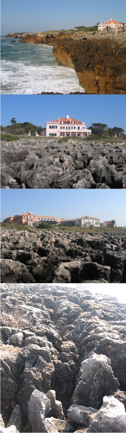 intersections. These remarkable flutings are only a special variety of 'grikes', but they are known internationally as lapies and they have become of special interest because they can also be formed on vertical surfaces of basic rocks other than limestones, provided that the water concerned has a sufficiently low pH value.
Simply put lapiés are weathered limestone surface found in karst regions and consisting of etched, fluted, and pitted rock pinnacles separated by deep grooves.
In order to understand and see the progressive development of lapies you should visit GC1PNFV, followed by this cache and then by GCHJ8R.
At GZ of this EarthCache you are in the middle of a intermediately developed lapiés field. The rock types are reef limestones of Lower Cretaceous (Hauterivian – Barremian; 136.4 to 125 M.a.) age striking NE and dipping gently to the SE cut occasionally by igneous dykes. The nature of this type of landscape makes observation more difficult but I ask you to:
- 1 - Do you see any preferred orientation of the grikes?
- 2 - If so what are they?
- 3- How high are the lapiés at this location?
- 4 - What interesting geological feature lies approximately 500 m to the west of this location?
Send these via e-mail to validadte your find.
Refs:
Holmes, A. 1981. Principles of Physical Geology (3rd Ed.). Thomas Nelson and Sons limited, 730p.
Ramalho, MM; Rey, J; Zbyszewski, G; Matos Laves, CA; Mointinho de Almeida, F; Costa, C and Kullberg; MC. 191. Carta geológica de Portugal na escala 1/50000. Notícia Explicativa da folha 34-C (Cascais). Serviços Geológicos de Portugal, 87p.
Moitinho de Almeida, F, 1959. Carta geológica de Portugal na escala 1/50000, Folha 34-C (Cascais).

os lapiás são os testemunhos superficiais da dissolução da rocha. De forma geral são grandes blocos de tamanhos variados que se estendem lado a lado e cobrem grandes áreas. Os lapiás normalmente são formados pela dissolução da rocha nos seus pontos de entrada, ou seja, a rocha que inicialmente possuía fracturas, que se abrem cada vez mais e acaba por se separar em blocos. Assim, os lapiás apresentam ranhuras ou caneluras que evidenciam o caminho da água.
No ponto zero estarão em cima de calcários recifais do Cretácico Inferior por vezes cortados por diques de rocha ígnea. A natureaza desta paisagem torna a observação mais complicada mas
1- existe alguma orientação preferencial das fendas (grikes)?
2- Se sim qual é ou quais são essas orientações?
3- Que altura têm os lapiás nesta localidade
4- qual a fenómeno geológico inteteressante a cerca de 500 m a oestedeste ponto?
Enviem-me as respostas por mail para validar mais um “found”.

 The most exciting way to learn about the Earth and its processes is to get into the outdoors and experience it first-hand. Visiting an Earthcache is a great outdoor activity the whole family can enjoy. An Earthcache is a special place that people can visit to learn about a unique geoscience feature or aspect of our Earth. Earthcaches include a set of educational notes and the details about where to find the location (latitude and longitude). Visitors to Earthcaches can see how our planet has been shaped by geological processes, how we manage the resources and how scientists gather evidence to learn about the Earth. To find out more click HERE.