From the guidelines, as from January 2013: "People do not need to wait for permission to log your EarthCache. Requiring someone to wait is not supported by the EarthCache guidelines. People should send their logging task answers to you, then log your EarthCache. When you review their logging task answers, if there is a problem, you should contact them to resolve it. If there is no problem, then their log simply stands."
 The chief chemical changes that occur during weathering are solution, oxidation, hydration or hydrolysis, and the formation of carbonates. Only a few common minerals resist decomposition, quartz and muscovite (including sericite) being the chief examples. Others, like the carbonate minerals, can be entirely removed in solution. Most silicate minerals break down into relatively insoluble residues, such as the various clay minerals, with liberation of soluble substances which are removed in solution.
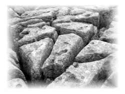
Limestone is scarcely affected by pure water, but when CO2 is also present the CaCO3 of the limestone is slowly dissolved and removed as calcium bicarbonate, Ca(HCO3)- Limestone platforms like those around the western Lisbon coast clearly show the effects of solution in their deeply grooved and furrowed surfaces. The joints are opened into 'grikes' with intervening ribs or 'clints' of harsh bare rock. The surface is free from soil except where a little wind-blown dust or tide driven sediment has collected in the crevices. Clints and grikes are stage ONE in the formation of Lapiés.
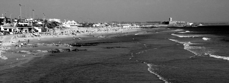
In the Lisbon coastal area these geomorphological features are developed on limestone platforms. These are often developed as a result of destructive waves hitting against a cliff face, causing undercutting between the high and low water marks, mainly as a result of corrasion and hydraulic power, creating a  wave-cut notch. This notch then enlarges into a cave. The waves undermine this portion until the roof of the cave cannot hold due to the pressure and collapses, resulting in the cliff retreating landward. The base of the cave forms the wave-cut platform as attrition causes the collapsed material to be broken down into smaller pieces, while some cliff material may be washed into the sea.
These platforms are often most obvious at low tide when they become visible as huge areas of flat rock.
In the western end of the Carcavelos beach we have a fairly well developed, yet small, limestone platform where clints and grikes are easily seen. These are Upper Cretaceous (Cenomanian – 99.6 to 93.5 M.a.) limestones strike ENE that dip very gently to the SE and are overlain by Miocene (23 to 5 M.a.) argillites further to the NE.
To claim this found you have to go the GZ at LOW TIDE and:
- measure the two main orientations of the grikes,
- Does the orientation vary or is it constant and;
- Measure the height of the clints.
Send these via e-mail to validadte your find.
Refs:
Holmes, A. 1981. Principles of Physical Geology (3rd Ed.). Thomas Nelson and Sons limited, 730p.
Ramalho, MM; Rey, J; Zbyszewski, G; Matos Laves, CA; Mointinho de Almeida, F; Costa, C and Kullberg; MC. 191. Carta geológica de Portugal na escala 1/50000. Notícia Explicativa da folha 34-C (Cascais). Serviços Geológicos de Portugal, 87p.
Moitinho de Almeida, F, 1959. Carta geológica de Portugal na escala 1/50000, Folha 34-C (Cascais).

 Na parte oeste da praia de Carcavelos existe uma pequena mas bem desenvolvida plataforma calcária que contem “clints” e “grikes”. São calcários do Cenomaniano inferior com cerca de 95 milhões de anos pouco inclinados para SE.
Para contabilizar mais um “found” precisam de se deslocarem ao local durante a maré baixa e:
- Medir as duas orientações principais dos “grikes”,
- Dizer se esta orientação é constante ou varia e
- Medir a altura dos “clints”.
Depois é só enviar as respostas por mail para validar mais um “found”.

 The most exciting way to learn about the Earth and its processes is to get into the outdoors and experience it first-hand. Visiting an Earthcache is a great outdoor activity the whole family can enjoy. An Earthcache is a special place that people can visit to learn about a unique geoscience feature or aspect of our Earth. Earthcaches include a set of educational notes and the details about where to find the location (latitude and longitude). Visitors to Earthcaches can see how our planet has been shaped by geological processes, how we manage the resources and how scientists gather evidence to learn about the Earth. To find out more click HERE.