| English Version |
Deutsche Version |
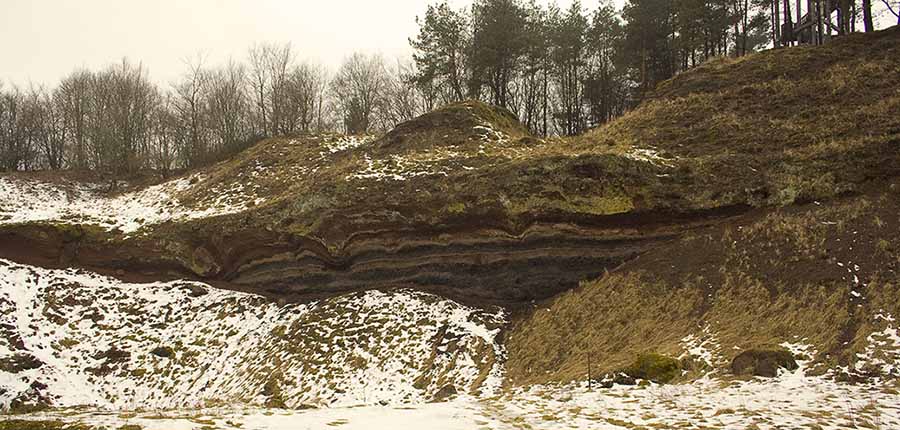
Forty million years ago the region
near Boos was affected by volcanism. The last active cinder cones
and maares have ceased to erupt about eight thousand years ago. The
earth cache location is situated 60 meters above the center of the
municipality of Boos. It is just a short trip from the center of
the village.
At the end of the 19th century people began to dismantle volcanic
rocks on Schneeberg [annotation: This is how that mountain is
called]. Within these activities the rim of the eastern maar was
cut off.
To reach this earth cache, you should leave your car at one of the
parking waypoints I added to this listing. If you prefer to park at
parking possiblity 2 [Park2], you can use a shortcut behind the St.
Bartholomew Church to the street "Am Kirchgarten", then to the left
and at the crossing take the path leading to the peak. This is the
shortes way to get there. If you prefer to park your car WP Park1
it is as simple as to follow the path north-east until you see the
signs reading "Lavabombe", that lead you to the site. |
Vor Vierzig Million
Jahren war die Gegend um Boos geprägt durch Vulkanismus. Die
letzten aktiven Schlackekegel und Maare haben vor 8 tausend Jahren
die aktive Eruption eingestellt. Der Earth Cache liegt 60 Meter
über dem Kern der Verbandsgemeinde Boos. Es ist nur einen kurzer
Trip entfernt.
Ende des 19ten Jahrhunderts begann man damit Vulkangestein am
Schneeberg [Anmerkung: So wird der Berg genannt] abzubauen. Dabei
wurde der Rand des östlichen Maares abgeschitten.
Um diesen Earthcache zu erreichen parke Dein Auto an einem der
beiden Parking Waypoints. Wenn Du Park2 bevorzugst, kannst Du eine
Abkürzung hinter der St. Bartholomäuskirche nehmen, die zur Straße
"Am Kirchgarten" führt, von dort nach links bis zur Kreuzung und
dort den Weg zum Gifel. Kann man eigentlich nicht verfehlen. Wenn
Du lieber bei Park1 parkst, folge einfach dem Weg nach nord-ost bis
Du zur Beschilderung kommst, die "Lavabombe" weist den Weg bis zum
Cache. |
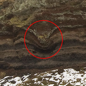 |
In this picture you can see one
lavabomb of about 250 kilograms weight that had impact into the
layers thus forming some of the waves. The bomb was ejected from
the eastern maar that is situated in a distance of about 430 meters
to the south-west [bearing 255°] from wall of waves. The force of
impact has deformed the layers beneath. If you search the wall, you
can see more of these bombs and deform traces. There are display
boards at the site that explain what happend here in the past. And
give a good overview over the time of Tortonian (Geochronology) age
and the events that lead to this waves. |
In diesem Bild sieht man eine
Lavabombe von ungefähr 250 Kilogramm, die in die Schichten
eingeschlagen ist und so einige Wellen geformt hat. Die Bombe wurde
aus dem östlichen Maar geschleudert, welches sich in einer
Entfernung von ca. 430 Meter süd-westlich [Peilung 255°] der Wellen
befindet. Die Wucht des Einschlags hat die darunterliegenden
Schichten ebenfalls verformt. In der Wand sind noch einige Bomben
mehr zu finden. Es gibt dort einige Anzeigetafeln auf denen
beschrieben ist, was hier während der Tortonium (Erdzeitalter) Zeit
passiert ist. |
To log this earthcache perform the
following tasks:
- Tell me why some layers in the wall are black and some are
red.
- Explain me of what material do these two types of layers
consist.
|
Um diesen Earthcache zu loggen must Du
folgende Aufgaben erledigen:
- Beschreibe mir warum einige Schichten in der Wand rot und
andere schwarz sind.
- Erkläre mir aus welchem Material diese beiden Schicht-Typen
bestehen.
|
Version 1.0 - Erste Veröffentilichung/Initial publish .. 7th of
April, 2009
Version 1.1 - Foto Log Bedingung entfernt/Photo Log Condition
deleted .. 3rd of January, 2011