What: breakfast meet 'n eat.
When: 9:00-9:30 am, Saturday, Oct. 31.
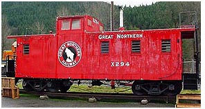
Where: red caboose at Iron Goat Interpretive Site on Hwy 2
at MP 58.3 (posted coords).
What to bring: beverage and breakfast (doughnuts to share?),
travel bugs, gossip.
The Iron Goat is a
historic rail line, the first to cross the northern Cascades. It
was a remarkable engineering feat in the late 1800s that helped
open the Northwest to settlement and commerce. (It's called the
Iron Goat because Great Northern Railway's logo was a mountain
goat.) Nine miles of the abandoned rail line has been converted to
a scenic and interpretive trail by the tireless Volunteers for
Outdoor Washington (VOW), who also partnered with WSDOT and the US
Forest Service to create this interpretive site and restored the
red caboose as its centerpiece.
This event is open to everyone – it's a large flat area next to
parking and ADA-accessible. Kids are sure to love climbing on the
red caboose, so all aboard! (And don't forget to sign the event
logbook!)

After the event, some of us plan to explore the 9-mile Iron Goat
Trail, a hiking-only trail that highlights the railroad history and
showcases tunnels, snowsheds, and other relics of the railroad era,
as well as lovely forests and great views. You'll also stand on the
site of the 1910 avalanche disaster, which killed almost a hundred
people when two trains stuck at Wellington were swept down the
mountainside into Tye Creek.
For those interested in hiking the trail, it's a gentle downhill
slope, suitable for walkers of any age and ability, and dogs are
welcome. Six miles of the trail is ADA-accessible; for specifics
see the Iron Goat website,
which also includes a map and driving directions.
We'll organize a car shuttle from the Interpretive Center up to
our start point at the Wellington trailhead (3100 ft). The hike
will head west in the downhill direction, with an opt-out point
near Windy Point (3.5 miles, 2800 ft; side trail descends 700 ft to
the Interpretive Center). We'll turn around at the trail's western
end at Martin Creek trailhead (6 miles, 2450 ft), and head down to
the Interpretive Center (9 miles, 2100 ft).
If you plan to hike the trail: Terrain rating is about 3, and be
sure to bring snacks/lunch, water, good walking shoes, appropriate
clothing, and your camera.
There are 12 geocaches along the trail; check out the
Iron Goat bookmark list. You can also find discussion of the
geocaching hike in
this forum thread.
 This event is sponsored by the Puget
Sound Chapter of the Washington State Geocaching Association.
If you are a geocacher in the state of Washington, please join
WSGA. See the WSGA
website for details. This event is sponsored by the Puget
Sound Chapter of the Washington State Geocaching Association.
If you are a geocacher in the state of Washington, please join
WSGA. See the WSGA
website for details. |