From the guidelines, as from January 2013: "People do not need to wait for permission to log your EarthCache. Requiring someone to wait is not supported by the EarthCache guidelines. People should send their logging task answers to you, then log your EarthCache. When you review their logging task answers, if there is a problem, you should contact them to resolve it. If there is no problem, then their log simply stands."

A volcano is a mountain that opens downward to a reservoir of molten rock below the surface of the earth. Unlike most mountains, which are pushed up from below, volcanoes are built up by an accumulation of their own eruptive products. When pressure from gases within the molten rock becomes too great, an eruption occurs. We are aware of volcanoes because certain regions have active volcanism that greatly affects local populations and also because captured images of flowing lava are spectacular and make for captive audiences. Normally what we see on National Geographic are the extremes of such events and also the most spectacular.
Volcanic eruptions involve the transport of lava (normally) from the mantle to a magmatic chamber where it accumulates and builds up sufficient pressure to allow it to escape to surface via a complex system of dykes and sills to chimneys and vents where it can finally be extruded as lava, ash, slag, lapilli and volcanic bombs amongst other pyroclastic products.
The last episode of volcanic activity in the Lisbon region dates from the Upper Cretaceous. From this episode resulted the “Lisbon Volcanic Complex” or CVL as it is locally known and whose “fingerprints” are scattered up and down the coast from Lisbon to Torres Vedras and are well known to geologists. The CVL outcrops over an extension of some 200 km2.
In the Guincho beach, at low tide, you can observe a set of outcrops that are the remnants of a paleo chimney from the CVL that most of you have seen but have not associated with the CVL. This would have been one of the feeders of the lavas of the CVL that we see so well represented nearby. The chimney stands about 2 m high at its maximum height and is but one of many associated with the CVL. The outcrops are associated in a circular or elliptical pattern. Other notable chimneys are Lexim and Montachique which are also associated with an EarthCache and a traditional cache, respectively.
In order to tally another found you will have to get yourself down to the beach at low tide and perform some careful observations:
- In a N-S direction what is the maximum diameter of this chimney? Here you will have to use your imagination and reconstruct the chimney.
- How many outcrops make up the remnants of this chimney?
- Who, or what, inhabits this chimney now?
- What colour are these rocks? I guarantee that they are not black!
- In your opinion what characteristic identifies these rocks as being of a volcanic origin?
Please send me your answers via the e-mail in my GC profile to validate the find.
To check the tides, Click HERE.

Um vulcão é mais que um amontoar impressionante de escoadas de lava e camadas de cinza e outros piroclastos. Aquilo que muitos de nós vemos através dos programas da National Geographic são normalmente os extremos dos fenómenos magmáticos e normalmente sempre os mais impressionantes.
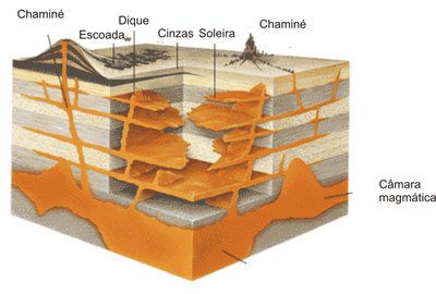 Uma erupção envolve o transporte do magma desde o manto (normalmente) para uma câmara magmática onde este se vai acumular até que a pressão do magma seja suficiente para o fazer ascender por um sistema de diques e soleiras até às chaminés ou fendas por onde vai finalmente ser extruído sobre a forma de lava, cinzas, lapilli, escórias, bombas vulcânicas entre outros produtos piroclásticos.
Quando um vulcão se extingue e deixa de ser alimentado pelo seu complexo sistema de condutas os agentes erosivos encarregam-se de expor as redes de diques, soleiras e chaminés que o constituíram.
O último episódio de actividade vulcânica na região de Lisboa deu-se durante o Cretácico Superior. Deste episódio resultou o agora denominado “Complexo Vulcânico de Lisboa” cujas “impressões digitais” são bem visíveis ao longo na costa portuguesa. O Complexo Vulcânico de Lisboa (CVL) aflora numa extensão de cerca de 200 km2 entre Lisboa e Torres Vedras.
Pegando um pouco na história geológica que antecede a implantação do CVL vemos que no Jurássico superior, o mar é regressivo, como se pode observar pelos depósitos de fácies marinho cada vez menos profundo, com calcários recifais, margas lagunares com leitos de carvão, etc. Apresenta também fácies continentais com séries de conglomerados, arenitos e argilas. O Cretácico inferior é ainda regressivo, mantendo-se a sedimentação continental do mesmo tipo que a anterior. Seguiu-se uma transgressão em que se constituíram depósitos calcários. O Cretácico superior está reduzido à região de Aveiro-Coimbra. É nesta época que se formam os maciços eruptivos de Sintra, Sines e Monchique, a que se sucederam fenómenos de vulcanismo testemunhados pelo denominado complexo vulcânico de Lisboa-Nazaré. Neste complexo encontram-se materiais extrusivos como lavas, piroclastos, filões, diques, chaminés e soleiras vulcânicas.
Esta cache pretende dar a conhecer uma paleo chaminé vulcânica; a qual muitos já viram, mas os afloramentos são sempre mais um obstáculo no caminho de muitos e poucos perdem o tempo para os observar devidamente.
Em plena Praia Grande do Guincho, quando a maré está baixa, “afloram” um conjunto de afloramentos de rocha básica que outrora terá sido uma chaminé vulcânica. A mesma pertence ao CVL e terá sido um dos pontos que alimentou a extrusão de lavas deste complexo. Hoje restam um número reduzido de afloramentos na praia distribuídos mais ou menos numa forma circular ou elíptica atestando para a estrutura da paleo chaminé.
Fazer mais um found nesta EarthCache vai requerer uma deslocação à praia do Guincho na maré baixa e fazer umas observações mais cuidadas.
- No sentido N-S qual a extensão máxima da chaminé. Aqui terão de usar a vossa imaginação e “reconstruir” parte da chaminé já erodida.
- Quantos afloramentos desta chaminé estão agora expostos na maré baixa?
- Quem habita estes afloramentos agora?
- De que cor são estas rochas. Posso adiantar que “pretas” não são.
- Qual é a particularidade destas rochas que as identifica como sendo rochas vulcânicas?
Enviem-me as respostas por mail para validarem mais um found.
Para saberem o estado da maré vejam AQUI.
 The most exciting way to learn about the Earth and its processes is to get into the outdoors and experience it f irst-hand. Visiting an Earthcache is a great outdoor activity the whole family can enjoy. An Earthcache is a special place that people can visit to learn about a unique geoscience feature or aspect of our Earth. Earthcaches include a set of educational notes and the details about where to find the location (latitude and longitude). Visitors to Earthcaches can see how our planet has been shaped by geological processes, how we manage the resources and how scientists gather evidence to learn about the Earth. To find out more click HERE.