JÖKULHLAUP AT SKEIDARARSANDUR IN 1996 (ICELAND) EarthCache
JÖKULHLAUP AT SKEIDARARSANDUR IN 1996 (ICELAND)
-
Difficulty:
-

-
Terrain:
-
Size:  (other)
Please note Use of geocaching.com services is subject to the terms and conditions
in our disclaimer.
„Jökulhlaup“ is the islandic word for „glacial run“. A glacial lake outburst flood is created when water dammed by a glacier or a moraine is released. A water body that is capped by the glacier is called a sub-glacial lake. A jökulhlaup is thus a sub-glacial outburst flood. Often this outburst is caused by volcanic activity, which makes the ice of the glacier melt.
The river Skeiðará is a relatively short glacial river (about 30 km long). It has its source on the glacier Skeiðarárjökull, one of the southern arms of the Vatnajökull south of Iceland. In spite of the short length, this river has a bad reputation. It is especially feared because of the frequent glacial runs that can be fatal.
In front of Skaftafell National Park Skeiðará has formed the Skeiðarársandur, a black plain of lava sand and ashes crossed by a lot of small rivulets which covers the whole area between the park and the sea (about 40 km long and 5 to 10 km wide). In 1996 a big glacier run took place. It destroyed parts of Route 1 (Ring Road). The 880 m long bridge was destroyed by floating ice boulders in the size of a house. At the peak of this glacier run, 50000 m³/s of water were coming down. Luckily, no persons were harmed, scientists having very carefully monitored the volcano Grimsvötn on Vatnajökull which caused the glacier run by its eruption.
Chronological diary of the activities in late 1996:
1.) Volcanic activities:
29th of September: A big earthquake underneath the Vatnajökull took place.
30th of September: Eruption of the Barðarbunga in the evening.
1st of October: Eruption begun in a four kilometer long gap between Grimsvötn und Barðarbunga. Holes in the surface of the glacier indicated a huge melting of ice. The shield of ice over the Grimsvötn climbed quick, which meant that water floods underneath. The volcanic eruption melted its way through the 500m thick ice within 30 hours.
2nd of October: The eruption was visible in a big caldera in the glacier. The volcanic gap reached three kilometers further north.
3rd of October: A big eruption took place in the north of the gap, but could not melt through the ice shield which is about 750m at this place. The eruption threw volcanic material 10 km into the air. A gorge opened itself in the glacier.
10th of October: The gorge reached a deepness of over 100 meters and a length of over 4 kms. The caldera, which is named „Gjalp“ is situated at the northern end of the gorge. Water flowed direction south in the gorge to Grimsvötn.
14th of October: The volcanic activity ended. The feared Jökulhlaup has not happen.
Allthough about 5000 cubic meters water per second melted and the ice shield over the Grimsvötn mounted 15-20 meters a day, the water could not flow out of the Grimsvötn.
2.) Jökulhlaup
5th of November:
8 a.m.: Gaps opened 1000mtrs from glacier top, first in the east, then continuosely towards west. Water, black from volcanic sediments, forced its way through the gaps, tearing huge ice blocks with it and run over the glacier.
8:30 a.m.: A flood wave, 3-4m high and 500-600m wide with a mixture of ice and mud run from the glacier over the Morsadalur and flowed down direction Skeidara bridge.
9 a.m.: The bridge was almost washed away. More and more outlets opened at the glacier.
10 a.m.: The water fought its way out of the glacial lake in the mid of Skeidararsandur wet land. Within 2 hours a gap occoured which run 1000 meters into glacier and was more than 250m in wide and 40m deep. About the half of the water of the glacial river came out of this gap and flowed into the Gigjukvisl. About 15 million cubicmeters of ice broke out of the glacier (the biggest piece waighed about 1000 tons and was torn away about 15 kms). The gap in the moraine through which the Gigjukvisl flowed, growed from 100 to 400m and the river channel engorged from 500 to 2000m at the street.
11 p.m.: Maximum of the Jökulhlaup. The water flooded with 50000 qm per second.
6th of November:
4 p.m.: The Jökulhaup is over.
In total: The whole volume that flooded out from the glacier was 3,5 Qubikkilometers and contained 185 million tons of sediments. The ice shield on the Grimsvötn lowered about 150m. After the eruption flooded the water unhindered from the volcanic zone over the Grimsvötn in the Skeiðara and then into the ocean.
In the Skaftafell Visitor center you can watch a video about the Jökulhlaup in 1996. It's very impressiv! Don't miss it!
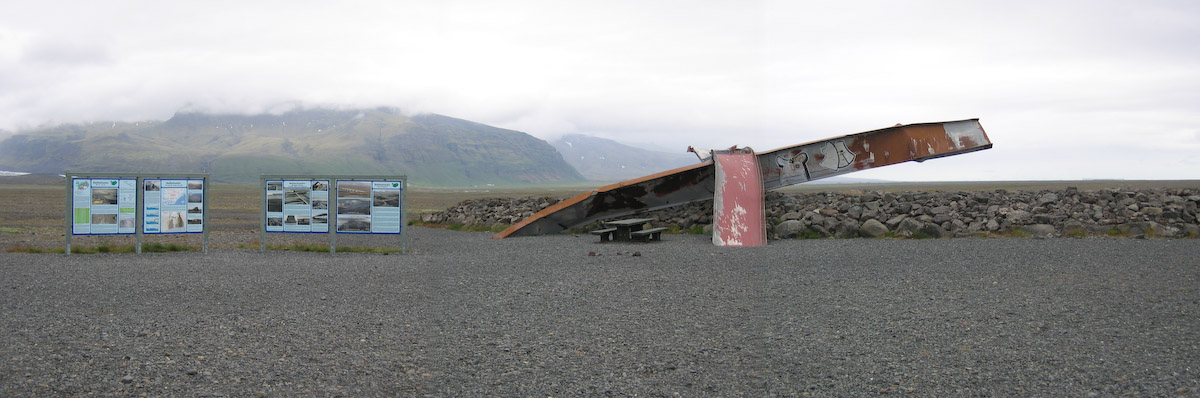
This earthcache guides you to the remains of the old Gigjukvisl bridge that was destroyed during the Jökulhlaup at 5th of November in 1996.
It is situated directly besides the new ring road 1.
To log this cache as a found, you have to
1.) upload a picture which shows you at the remains of the twisted bridge to proove you have been psysically there, (this is an optional task since 1.1.2011)
2.) contact me via geocaching and awnser the following questions before logging:
a) At 11p.m. at 5th of November had been the maximum of the glacier run. Assuming that a „normal bathtube“ contains about 200 liters of water when full, figure out, how many bathtubes could have been filled theoretically per second at that time?
b) You can observe that the stones/ sands/ sediments are getting more smaller when you drive through Skeidararsandur from the glacier towards the ocean. Tell me in short and simple words your explanation for that.
c) Edit 2.8.21: Foto-upload of you, part of you, your GPSr... in your online-log is required (re-allowed by GC since June 2019)
Logs without the required e-mail will be deleted. Due to "administration" of the log-permissions it is nessecary that every team send an e-mail by itsself even if you were there together. Do not wait for log-permission, just log your found directly after sending the mail; we will contact you if there is something wrong.
Thanks to Team Wilmar for reassuring the coordinates and making the picture.
Additional Hints
(No hints available.)