Bisti Badlands EarthCache
-
Difficulty:
-

-
Terrain:
-

Size:  (not chosen)
Please note Use of geocaching.com services is subject to the terms and conditions
in our disclaimer.
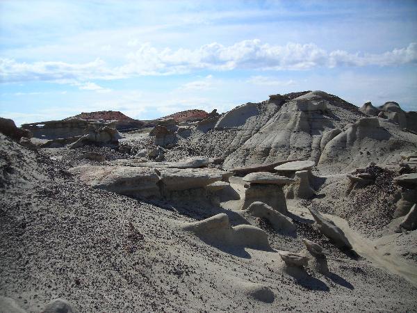
Take a walk in a parched no-man’s land with unusual
formations that make you think you might be on the moon and being
watched by aliens. Over millions of years, the wind, rain and
elements have carved many unusual features in this remote area.
The Bisti/De-Na-Zin Wilderness Area consists of 45,000 acres set
aside by Congress in 1996. Translated from the Navajo language,
Bisti means “a large area of shale hills” and is
pronounced (Bis-tie). De-Na-Zin (Deh-nah-zin) takes its name from
the Navajo words for “cranes.” Petroglyphs of cranes
have been found south of the wilderness area. This entire area is
referred to as the Bisti Badlands.
Formation of the Area:
During the Cretaceous Period, some 80-65 million years ago, there
was lush vegetation, swamplands and forests. Eventually the seaways
slowly retreated leaving vast flood plains of sediment.
There are two major geological formations that make up this
Wilderness, the Fruitland Formation and the Kirtland
Formation.
The Fruitland Formation, with a thickness of about 500 feet, is
made up of varying proportions of interbedded sandstone, shale,
mudstone, silt, and coal. The fine to medium grained sandstone beds
are gray, brown, and olive in color. This is what you will
primarily see when in the Bisti.
The Kirtland Formation (Kirtland Shale) is approximately 1,500 feet
thick containing various colored rocks and is primarily located in
the eastern part of the Wilderness. The red hills that you see were
formed by coal fires baking the clay soils millions of years
ago.
Many of the unique formations in the area are topped with a harder
layer that somewhat protects the feature. Despite these protective
hats, rain and wind still cause erosion and can change the look of
a feature easily. Some of the names associated with these features
are:
Spires - a smooth outcropping with a uniform thickness that
tapers from the ground upward.
Hoodoos - A tall spire with different thicknesses such as a
totem pole.
Mushroom - a short version of a hoodoo
The majority of these formations can be found on the South side of
the wash that you will see from the parking area.
The Bisti/De-Na-Zin Wilderness Area is open year round, however the
temperatures can be extreme during the summer and the roads and
area can be impassable during rains, as the ground can become
slippery and leaves footprints that can take years to
disappear.
There are no developed trails or signs and you are encouraged to
discover the wonders of the wilderness. Exploring the many carved
out enclaves leading from the washes allows the opportunity to
experience solitude and a primitive type of recreation.
The area is closed to motorized vehicles and mechanical forms of
transportation (mountain bikes included). Also prohibited are
campfires, collecting fossils or petrified wood, climbing on
delicate geologic features, traveling in groups of more than eight
people, and trespassing on adjacent tribal lands.
Directions:
To reach the Bisti/De-Na-Zin Wilderness Area, go south on NM 371
about 36 ½ miles from the San Juan River crossing in Farmington and
turn on to Road 7297 (not county maintained). Follow the gravel
road for about 2 miles to the Bisti parking lot. From Crownpoint go
north on NM 371 about 46 miles, just past the Don Gleason Bridge
over the De-Na-Zin Wash to the turn.
Topographic Maps for this area include: Alamo Mesa West, Alamo Mesa
East, Bisti Trading Post, and Tanner Lake.
Note: This Earthcache can be accomplished during the same trip
as “Trees, What Trees?” (GC1PNHE)
, they are in the same general area.
Logging Requirements:
The above coordinates will take you to a unique feature a little
more than a mile from the parking area. To log this
Earthcache:
1. Post a picture of you/your group exploring the area.
Please do not post pictures of this feature. (Optional)
E-mail me the answers to these questions:
2. Describe what you think this feature looks like (do not
post a picture of it).
3. On the feature there are 2 layers, what makes up these
layers and what formation is it?
4. What geologic time Era is the Cretaceous Period a part of
(a little internet searching will help)? (Optional as of January 1,
2011)
Be sure that you provide your e-mail address when you send the
answers to the above questions so that I can respond to your
answers faster. I will respond to all, as I feel it is an important
part of owning an Earthcache.
Other waypoints:
Turn Off from NM 371: 36 13.918 108 16.282
Parking Area: 36 15.736 108 15.173
References:
Bisti/De-Na-Zin Wilderness, Bureau of Land Management Wilderness
Area Northwest New Mexico Brochure
Scotese, C.R., 2002, http://www.scotese.com
U. S. Department of the Interior Bureau of Land Management
Recreation Guidelines and information:
http://www.nm.blm.gov/recreation/recreation_guidelines.htm
This Earthcache was placed with permission of the
Bureau of Land Management
Farmington Field Office
Congratulations to
kingbee on FTF!
Additional Hints
(No hints available.)