Die Kreidefelsen von Jasmund
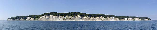
Mehr als hundert Meter ragen am Rande des Stubnitz-Waldes im Nationalpark Jasmund auf der Insel Rügen die sagenhaften weißen „Kreidefelsen von Jasmund“ empor. Die Kreidefelsen bilden eine etwa 10km lange Kreideküste, welche eine KliffküsteKreidefelsen der Kreideküste sind nicht sehr fest oder hart. Denn Kreide ist ein sehr weiches Gestein, dass man die Felsen sogar mit dem Fingernagel ritzen kann. Die Kreide der Kreideküste, auf der Insel Rügen entstand vor ca. 70 Millionen Jahren, im jüngsten Abschnitt der Kreidezeit. Das damalige Schelfmeer, ein Flachsee von höchstens 200m Tiefe, an dessen Boden sich vor etwa 70 Millionen Jahren die Kreide ablagerte, bedeckte seiner Zeit weite Teile des heutigen Norddeutschlands, des Ostseeraumes und Südskandinaviens. Das Wasser des flachen Meeres war besonders reich an Plankton und Panzergeißeltierchen.
In der zweiten Hälfte der Kreidezeit, also vor etwa 95 Mill. Jahren, in der Zeit als das Aussterben der Dinosaurier stattfand, bildeten sich auf dem Meeresgrund mehrere hundert Meter starke Schichten von Ablagerungsgesteinen, zumeist aus Kreide. Kreide-Gestein besteht aus Calciumcarbonat und ist ein feines, mikrokristallines Sedimentgestein, das durch Ablagerung von gefälltem Calcit (Kalkstein) sowie der Schalen von fossilen Kleinlebewesen wie Coccolithen der Coccolithophoriden und Schalen der Kammerlinge (Foraminifera) entsteht. Kreide tritt an zahlreichen Standorten entlang des europäischen Kreidegürtels zutage, von Großbritannien über Frankreich bis hin zur Insel Rügen in Norddeutschland, und wird stellenweise auch abgebaut.
Der größte Kreidefelsen auf der Insel Rügen ist der Königsstuhl mit einer Höhe von 118 m.Die beste Sicht auf den Königsstuhl selber hat man von der naheliegenden Viktoria-Sicht oder vom steinigen Ostseeufer, das hier etwa 118 Meter tiefer liegt und über rund 500 Stufen Abstieg erreicht werden kann.
Um diesen Earthcache zu loggen:
Mache bitte ein Foto von Dir mit deinem GPS (freiwillig) am Fuße der vielen Stufen und füge ein 2. Bild von Dir am Strand ein.
Desweiteren beantworte mir bitte folgende Fragen per Mail:
Wie wird in der Erdgeschichte die älteste chronostratigraphische Stufe der Unterkreide genannt?
sende deine Antwort an: ......@arcor.de - die Punkte sind durch das Lösungswort der ersten Antwort zu ersetzen, oder schreibe mich über mein Profil an.
Sollte mit Deiner Antwort etwas nicht in Ordnung sein werde ich mich bei Dir melden.
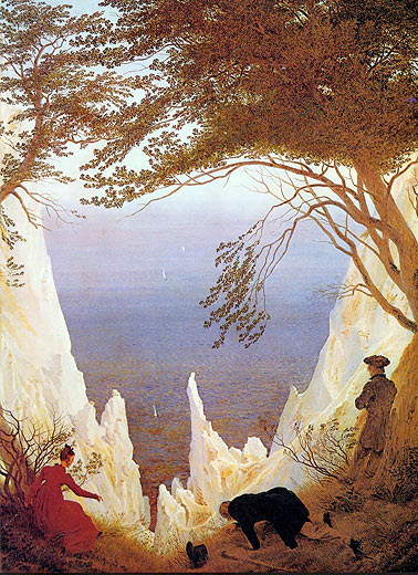
Caspar David Friedrich 1750
The chalk rocks of Jasmund
More than hundred meters rise up at the edge of the Stubnitz forest in the national park Jasmund on the island Rügen are the incredible white „chalk rocks of Jasmund “. The chalk rock form one for instance 10km long chalk coast, which represents a cliff coast. The chalk rock of the chalk coast are not very firm or hard. Because chalk is a very soft rock that one can cut the rock even with the fingernail. The chalk of the chalk coast, on the island reproaches developed approx. 70 million year ago, in the recent section of the chalk time. The shelf sea at that time is a flat lake of at the most 200m depth, at whose ground approximately 70 million years ago the chalk settled, covered its time far parts of today's Northern Germany, the Baltic Sea area and south Scandinavia. The water of the flat sea was particularly rich at Plankton and Panzergeißeltierchen.
In the second half of the chalk time, thus before approximately 95 Mill. years, in which time took place as becoming extinct the dinosaurs, several hundred meters strong layers of deposit rocks formed, mostly from chalk on the sea-bottom. Chalk rock consists of calcium carbonate and is a fine, micro-crystalline sedimentary rock, which results from deposit of Calcit (limestone) as well as the bowls of fossil small organisms such as Coccolithen of the Coccolithophoriden and bowls of the Kammerlinge (Foraminifera). Chalk comes at numerous locations along the European chalk belt to light, from Great Britain over France up to the island Rügen into Northern Germany, and is in parts also reduced.
The largest chalk rock on the island Rügen is the king chair with a height of 118 m. The best view on the king chair could be from the obvious Viktoria view or from the stony Baltic Sea bank, which lies here about 118 meters below and can over approximately 500 stages descent be achieved.
In order to log this Earthcache:
Make please a photo of you with your GPS (voluntarily) at the foot of the stages and insert a 2nd picture of you at the beach.
Further answer to me the following questions by mail:
What ist the name of the oldest chronostratigraphische stage of the lower chalks?
send your answer to : ...... @arcor.de - the points have to be replaced by the solution word of the first answer, or write your answer over my profile to me.