From the guidelines, as from January 2013: "People do not need to wait for permission to log your EarthCache. Requiring someone to wait is not supported by the EarthCache guidelines. People should send their logging task answers to you, then log your EarthCache. When you review their logging task answers, if there is a problem, you should contact them to resolve it. If there is no problem, then their log simply stands."

Jovan Cvijic was born in western Serbia and studied widely in the Dinaric Kras. His publication of Das Karstphänomen (1893) established that rock dissolution was the key process and that it created most types of dolines, “the diagnostic karst landforms”. The Dinaric Kras thus became the type area for dissolutional landforms and aquifers; Germanicised as “karst”, the regional name is now applied to modern and paleo-dissolutional phenomena worldwide. Cvijic related the complex behaviour of karstic aquifers to development of solutional conduit networks and linked it to a cycle of landform evolution. He is recognized as “the father of karst geomorphology”.
Different terms for karst topography exist in other languages but the international community has settled on karst, the German name for Kras, a region in Slovenia partially extending into Italy (where it is called Carso) where the first scientific research of a karst topography was made.
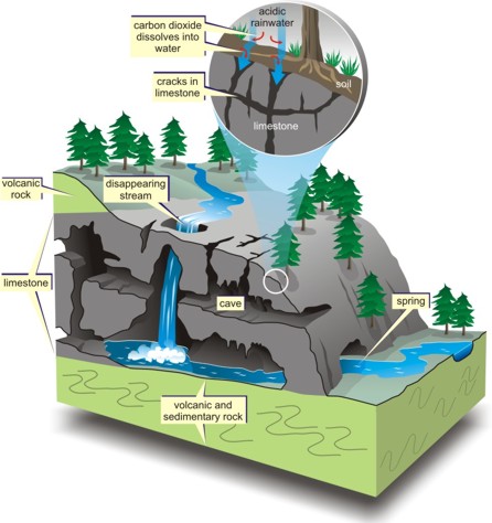
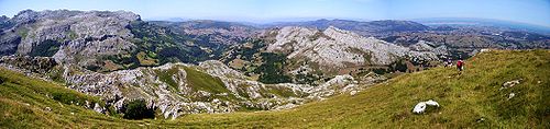
Karst topography is a landscape shaped by the dissolution of a layer or layers of soluble bedrock, usually carbonate rock such as limestone or dolomite. Due to subterranean drainage, there may be very limited surface water, even to the absence of all rivers and lakes. Many karst regions display distinctive surface features, with sinkholes or dolines being the most common.
The karstification of a landscape may result in a variety of large or small scale features both on the surface and beneath. On exposed surfaces, small features may include flutes, runnels, clints and grikes, collectively called karren or lapiez. Medium-sized surface features may include sinkholes or cenotes (closed basins), vertical shafts, foibe (inverted funnel shaped sinkholes), disappearing streams, and reappearing springs. Large-scale features may include limestone pavements, poljes and blind valleys. Mature karst landscapes, where more bedrock has been removed than remains, may result in karst towers or haystack/eggbox landscapes. Beneath the surface, complex underground drainage systems (such as karst aquifers) and extensive caves and cavern systems may form.
The weathering of limestone produces Terra rosa which is a type of red clay soil. When limestone weathers, the clay contained in the rocks is left behind, along with any other non-soluble rock material. Under oxidizing conditions, when the soils are above the water table, iron oxide (rust) forms in the clay. This gives it a characteristic red to orange colour.
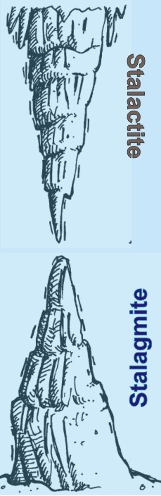 Common of karst caves are stalactites and stagmites. A stalactite (Greek stalaktites, (Sta?a?t?t??), from the word for "drip" and meaning "that which drips") is a type of speleothem (secondary mineral) that hangs from the ceiling or wall of limestone caves while a stalagmite (from the Greek stalagma ("Sta?a?µ?t??"), "drop" or "drip" is a type of speleothem that rises from the floor of a limestone cave due to the dripping of mineralized solutions and the deposition of calcium carbonate.
Stalactites are formed by the deposition of calcium carbonate and other minerals, which is precipitated from mineralized water solutions. Limestone is calcium carbonate rock which is dissolved by water that contains carbon dioxide forming a calcium hydrogencarbonate solution. The chemical formula for this reaction is:
CaCO3(s) + H2O(l) + CO2(aq) yielding Ca(HCO3)2(aq)
This solution travels through the rock until it reaches an edge and if this is on the roof of a cave it will drip down. When the solution comes into contact with air the chemical reaction that created it is reversed and particles of calcium carbonate are deposited. The reversed reaction is:
Ca(HCO3)2(aq) yielding CaCO3(s) + H2O(l) + CO2(aq)
An average growth rate is 0.13 mm a year. The quickest growing stalactites are those formed by fast flowing water rich in calcium carbonate and carbon dioxide, these can grow at 3 mm per year.
Every stalactite begins with a single mineral-laden drop of water. When the drop falls, it leaves behind the thinnest ring of calcite. Each subsequent drop that forms and falls deposits another calcite ring. Eventually, these rings form a very narrow (0.5 mm), hollow tube commonly known as a "soda straw" stalactite. Soda straws can grow quite long, but are very fragile. If they become plugged by debris, water begins flowing over the outside, depositing more calcite and creating the more familiar cone-shaped stalactite. The same water drops that fall from the tip of a stalactite deposit more calcite on the floor below, eventually resulting in a rounded or cone-shaped stalagmite. Unlike stalactites, stalagmites never start out as hollow "soda straws." Given enough time, these formations can meet and fuse to create columns.
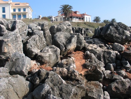
The coastline west of Lisbon is mostly made up of limestones of Cretaceous age (145 to 65 M.a.) that outcrop freely and abundantly throughout the area and are punctuated with occasional remnants of the Lisbon Volcanic Complex (CVL in the geological maps).They are typically mostly marly limestones with a fair amount of carbonaceous material and are clearly seen on the beaches lining the western Lisbon coastline. At ground zero the limestones are fairly compact and clean.
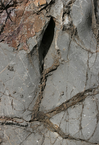
The EarthCache site chosen to show all these features is one where a paleokarst has been preserved (this site was once a cave) and filled with terra rosa. At ground zero, look for the terra rosa (red in colour – see the image below) and search for preserved stalactites and stalagmites. As you have read above, remember that these features invariably form concentric ring structures and that the stalactites here are of the “soda straw” type and hence have a hole in the middle while the stalagmites do not.
If you are having trouble remembering which is which, remember the following:
 StalacTite – “T” for top; i.e. they hang from the roof.
StalagMite – “M” for mat, i.e. they are on the floor. Remember this and you will never get confused again -;)
Your tasks in order to claim this find are to find these features (they will need careful observation – do not go at night) and.......
- What is the diameter of the thickest stalactite you can find?
- What is the diameter of the central canal of that stalactite?
- What is the diameter of the thickest stalagmite you can find?
- What is the total area occupied by the terra rosa at this locality?
Send me the answers via e-mail to validate your find.
Sources: http://en.wikipedia.org/wiki/Karst; http://en.wikipedia.org/wiki/Stalactite; http://en.wikipedia.org/wiki/Terra_rosa_(soil)

Carste ou Carso ou ainda Karst, também conhecido como relevo cárstico ou sistema cárstico, é um tipo de relevo geológico caracterizado pela dissolução química (corrosão) das rochas, que leva ao aparecimento de uma série de características físicas, tais como cavernas, dolinas, vales secos, vales cegos, cones cársticos, rios subterrâneos, canhões fluviocársicos, paredões rochosos expostos e lapiás. O relevo cárstico ocorre predominantemente em terrenos constituídos de rocha calcária, mas também pode ocorrer em outros tipos de rochas carbonatadas, como o mármore e rochas dolomias.
 O termo Carste deriva do alemão Karst (em português, Carso), nome de uma região que se estende do norte da Itália até o sudoeste da Eslovênia e o noroeste da Croácia. O nome local em língua eslovena Kras, significa aproximadamente "campo de pedras calcárias". A região também é chamada Carso em italiano. Esta região possui um sistema geológico cárstico e foi a primeira região onde esse fenômeno foi estudado.
O processo de carstificação ou dissolução química se inicia pela combinação da água da chuva ou de rios superficiais com o dióxido de carbono (CO2) proveniente da atmosfera ou do solo (proveniente das raízes da vegetação e matéria orgânica em decomposição). O resultado é uma solução de ácido carbónico (H2CO3), ou água ácida:
H2O + CO2 seta p/direita H2CO3
Este tipo de paisagem ocorre principalmente em regiões com pluviosidade elevada, que garante um fluxo de água suficiente para dissolver grandes porções de rocha. Também é importante a presença de vegetação para garantir que a água penetre no solo e não seja perdida para a atmosfera. Regiões cársticas possuem muito poucas águas superficiais, uma vez que a água da chuva é rapidamente absorvida pelo solo e se acumula na zona freática. Ao passar pelas fissuras a água corrói o carbonato de cálcio (CaCO3) ou outros sais constituintes da rocha, como sulfato de cálcio ou carbonato de magnésio. No caso da calcite, composta basicamente de carbonato de cálcio, o resultante dessa reação é uma solução de bicarbonato de cálcio:
CaCO3 + H2CO3 seta p/direita Ca(HCO3)2
Os sais removidos da rocha são carregados pela água em direção às camadas geológicas mais baixas. Ao atingir a zona freática, a água pode correr em rios subterrâneos abrindo cavidades na rocha, principalmente por erosão química, mas também pode ocorrer erosão mecânica em zonas vadosas (acima do lençol freático). Os sais podem se sedimentar em camadas geológicas inferiores ou serem arrastados para fora através de nascentes ou ressurgências.
Quando a água é absorvida pelo solo seu pH é ácido. À medida que a água se infiltra na rocha e o carbonato de cálcio se dissolve, o pH se torna cada vez mais básico. Nos locais em que esse processo ocorre é comum a presença de água dura (com alta quantidade de magnésio e cálcio). O pH alcalino faz com que os sedimentos se precipitem rapidamente. Isso favorece a formação de espeleotemas no interior das cavernas e também mantém as águas de regiões cársticas sempre límpidas.
A disolução de rochas carbonatadas dámuitas vezes origem a estalactites e estalagmites. As estalactites são formações rochosas sedimentares que se originam no teto de uma gruta ou caverna, crescendo para baixo, em direção ao chão da gruta ou caverna, pela deposição (precipitação) de carbonato de cálcio arrastado pela água que goteja do tecto. Apresentam frequentemente uma forma tubular ou cónica enquanto que as estalagmites são formações que crescem a partir do chão de uma gruta ou caverna que vão em direção ao teto, formadas pela deposição (precipitação) de carbonato de cálcio arrastado pela água que goteja do tecto.Uma particularidade destas formações são que a estalactite tem um canal no meio por onde escorre a agua que a forma enquanto a estalagmite é compacta da base até ao topo.
A localidade escolhida para esta EarthCache é hoje um paleocarso. Ou seja, já foi um mas agora está preservado tipo fóssil e cheio de terra rossa (um solo residual que é um depósito detrítico resultante da acumulação de argilas, areia fina e óxidos de ferro em virtude da dissolução dos calcários). Nesta Terra rossa existem preservados estalactites e estalagmites que têm de observar para conseguirem responder às seguintes perguntas:
1- Qual é o diametro da estalactite mais grossa que vês?
2- Qual é o diametro do canal central dessa estalactite?
3- Qual é o diametro da estalagmite mais grossa que vês?
4- Qual é a área (+/-) ocupada pela terra rossa?
Enviem-me as respostas por mail para validarem mais um found.

 The most exciting way to learn about the Earth and its processes is to get into the outdoors and experience it first-hand. Visiting an Earthcache is a great outdoor activity the whole family can enjoy. An Earthcache is a special place that people can visit to learn about a unique geoscience feature or aspect of our Earth. Earthcaches include a set of educational notes and the details about where to find the location (latitude and longitude). Visitors to Earthcaches can see how our planet has been shaped by geological processes, how we manage the resources and how scientists gather evidence to learn about the Earth. To find out more click HERE.