Precambrian Shield Folds EarthCache
-
Difficulty:
-

-
Terrain:
-

Size:  (other)
Please note Use of geocaching.com services is subject to the terms and conditions
in our disclaimer.
-- THIS IS AN EARTHCACHE, READ BELOW FOR LOGGING REQUIREMENTS --
In the Heart of the Town of Bala, there is a roadside stop set up to view the Bala Falls, and one of the many rock-cuts in the area for viewing the black, pink and red earth art existing in the precambrian shield.
This rock outcrop is composed of Granetic Gneiss, infused with Feldspar (pink) and Mica (black). These rocks were created by cooled molten rock from volcanoes and fissures nearly 2 billion years ago in the Precambrian era. Different chemical compositions of the magma, as well as timing of the placement have given the rock different colours, hues and shades.
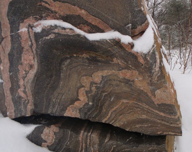
banded layers in the rock denote different chemical compositions
When the rock was still molten, folds were created by friction, collisons with other semi hardened magma, and temperature fluctuations. The result is highly chaotic, unpredictable, and beautiful patterns in the rock. The Banding formations seen are a result of "ferromagnesian" minerals being melted by the magma.
Ferromagnesian minerals accumulated iron and magnesium from surrounding rocks, essentially clumping the minerals together. The result of this accumulation was Ferromagnesian minerals surrounded by iron and magnesium depleted rocks - such as quartz and feldspar. When the rocks began to melt, the minerals melt first, enriching the surrounding rocks in ferromagnesian minerals. The Granite becomes very plastic-like and warps and bends as it moves, melts, and cools.
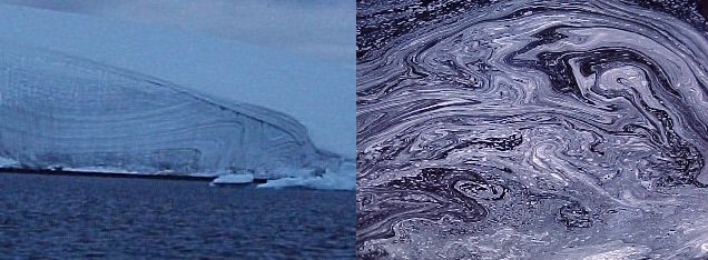
sedimentry folding (such as ice or glaciers) is far more predictable and uniform then igneous folding (such as bubbles on water)
Rock cuts in this area are common due to the nature of the surrounding nature of the terrain. Without a rock cut, the mica-laden gneiss would erode quicker then the fedspar laden geniss and create a crack, rather then a nice black line through a pink or red rock.
TO LOG THIS CACHE:
Go to the posted coordinates. You will find a plaque detailing the Precambrian Shield. Behind the plaque is a rock cut. Find on this rock cut (or one of the many others around town) a fold that has both a PEAK and a TROUGH. You will need a ruler or measuring tape and a camera to meet the following requirements. Please do not log this cache until you are prepared to complete all the required tasks.
MEASURE AMPLITUDE OF WAVE: Measure the vertical distance between a trough and a peak and divide that number by two.
MEASURE WAVELENGTH OF FOLD: Measure the horizontal distance between two similar positions on neighbouring folds (ex. crest to crest or trough to trough). This is the wavelength of the fold.
CALCULATE ASPECT RATIO: Determine the aspect ratio (P) of the fold by dividing A by M (P = A/M)
The aspect ratio can be used to describe folds. With this number (P), assign the fold you measured one of the following descriptive terms:
- Wide if P is between 0.1 and 0.25
- Broad if P is between 0.25 and 0.5
- Equant if P is between 0.5 and 2
- Short if P is between 2 and 4
- Tall if P is between 4 and 10
INCLUDE WITH YOUR FOUND LOG:
- A picture of the fold with including something else in the picture for size comparison (ideally a ruler)
- A description of the aspect ratio using the above guidelines.

Click the logo to visit the COG website!
Additional Hints
(No hints available.)