Ancient Beaches EarthCache
-
Difficulty:
-

-
Terrain:
-
Size:  (not chosen)
Please note Use of geocaching.com services is subject to the terms and conditions
in our disclaimer.
Ancient Beaches
The area of Petone sits on a delta formed of gravels and sands that
have been washed down by the Hutt River over thousands of years. A
series of beach ridges, representing former shorelines, have been
found to extend across Petone.
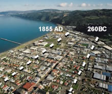
These humps running parallel to the Petone Foreshore are uplifted
beaches that have been preserved after past earthquakes. The oldest
raised beaches located around Udy Street and Wakefield Streets are
up to 4,500 years old. The last sudden beach uplift occurred during
the 1855 Wairarapa earthquake.
At the intersection of William Street and Jackson Street, an old
beach ridge dates back to around 2,300 years based on radiocarbon
dating of shells found in the sand. One of the best and most
noticeable ancient beach ridges can be found near the intersection
of William Street and Emerson Street.
Location
To get to these ancient beach ridges drive, bike, walk, skateboard,
or whatever to the following co-ordinates:
Intersection of William Street and Jackson Street: S 41 13.689 E
174 53.265
Intersection of William Street and Emerson Street: S 41 13.563 E
174 53.330
Earthcache Tasks
At the advertised locations you will need to perform the following
tasks to be able to claim the cache. Failure to comply with the
logging requirements may result in your online log been deleted.
Please forward your answers by email and wait for confirmation
before logging. Do NOT post any of your answers with your log!
1. What is the difference in altitude of the two advertised beach
ridges? Be careful at William Street and Jackson Street as the
ridge runs down the middle of Jackson Street - Take the reading
from the middle of the pedestrian crossing there. Don't forget to
take the reading with your GPSr on or as close as possible to the
ground!
2. When standing on the former beach ridge near William Street and
Emerson Street, there is a power pole on the eastern side of the
street at the apex of the beach ridge - what does the sign attached
to it advertise?
3. When standing on the former beach ridge near William Street and
Emerson Street, what is the man-made structure when looking to the
northern end of William Street?
4. Finally, take a photo of your GPSr (and yourself if you wish!)
near the ground zero of the beach ridge at William and Emerson
Streets, clearly showing the elevation of the ancient preserved
beach and post it with your log.

|
waiiti20 |

|
boxhill |

|
gray-ghost |
FTF medals created & designed by bjtrekker
Additional Hints
(No hints available.)