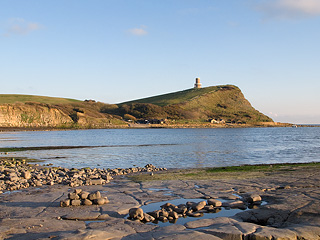
Clavell Tower was built in 1830 by Reverend John Richards Clavell as an observatory and folly. It became derelict after being gutted by fire in the 1930s and by 2006 was in danger of falling into the sea due to cliff erosion. Happily it was saved by the Landmark Trust who dismantled it piece by piece, rebuilt it 25 metres inland, and restored it to its former glory.
The tower is now let out for holidays but can be visited on open days in September. Our photos below (click to enlarge) show the inside of the tower when it was re-opened on 30 August 2008.
Limited free parking is available at the quarry car park at the coordinates below. The cache has been designed to give a circular walk from here but if the car park's full it's still possible to do the cache from the Kimmeridge Bay car park. (See Additional Waypoints.)
This is quite a challenging walk with some steep sections, and parts of the route can be muddy in the winter but we hope you'll agree that the views are worth the effort!
Refreshments are available at Clavell's in the village near the start of the walk, or you could move your car to the cafe car park after the walk.
The cache itself is hidden on the Lulworth Army Ranges which are only open at weekends (with a few exceptions) and most school holidays. Please check the Lulworth Range Walks Opening Times before you set out, and keep to the marked paths.
Note that the red flags fly all the time on the Lulworth Ranges, indicating danger from military debris. Only the marked paths ("Range Walks") are safe as these are checked for debris before the ranges are opened.
To find the coordinates of the cache you need to visit the following six locations (in order) and collect some numbers at each.
Turn right out of the quarry car park and at the bend in the road cross the stile signposted to Kimmeridge. Go through the village and continue along the toll road to the end.
Stage 1: Finger Post
N 50° 36.517 W 002° 07.771
How many fingers does the finger post have? Answer = a
Go up the steps signposted to Chapman's Pool to Stage 2.
Stage 2: Clavell Tower
N 50° 36.450 W 002° 07.809
How many horizontal bars make up the wooden gate to the tower enclosure? Answer = b
Go back down the steps and follow the coast path west to Stage 3.
Stage 3: Nodding Donkey
N 50° 36.780 W 002° 08.160
According to the information board the oil produced at Kimmeridge comes from rock how many metres below sea level? Answer = 5c0
Follow the coast path through the Ranges between the yellow markers to Stage 4.
Stage 4: Metal Gate
N 50° 36.715 W 002° 09.040
How many horizontal bars make up the metal gate at the cattle grid? Answer = d
Follow the zig-zag path up the hill between the yellow markers to Stage 5.
Stage 5: Stone Waymarker
N 50° 37.050 W 002° 09.500
How many words are on the stone waymarker? Check both sides! Answer = 1e
Follow the path along the ridge to Stage 6.
Stage 6: Tyneham Cap
N 50° 37.028 W 002° 09.258
How many curved slats form the back of the wooden bench? Answer = 1f
Using the numbers collected the cache is at N 50° 37. (b-a) (c+d) (f-c) W 002° 08. e (c+d) f.
The checksum of all the digits in the final coordinates is 49.
By necessity the hiding place is only just off the path so please be extra wary of passing muggles when retrieving and replacing the cache. Move away to sign the log book if you can. There's no need to dismantle the hiding place which was purpose built, and with permission. You only need to lift the top middle stone to reveal the cache.
The cache is a 1.2 litre lock & lock box and was last restocked on 13 April 2024. Please trade fairly. All our trade items are new and cost around £1. We'd appreciate it if you could mention what you swop in your online log.
It might be best not to leave trackables in this cache as it doesn't get many visitors!
After replacing the cache follow the ridge path east back to the quarry car park. Look out for Corfe Castle to the north east, and on the ridge to the north, the battlements of Grange Arch, another folly with a cache!
This cache (and hiding place) has been placed with the kind permission of the MoD.
