***About The Artist***
Henry Church (1836-1908) was a self taught painter, sculptor and
musician. He was born in Chagrin Falls, Ohio. His passion for art
from an early age led him to spend all of his free time working on
his craft. In 1884 he opened his own store and museum at the Geauga
Lake amusement park. During this time in his life he produced some
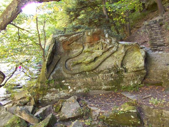
of his important work. What is to be considered the most important
and to some culturally offensive is the sculture carved out of a
massive block of sandstone that lies at the edge of the Chagrin
River called Squaw Rock. The original name of the sculpture was
"The Rape of the Indian Tribes by the White Man" The sculpture took
Henry Church several years to complete but only one side of the
piece was ever finished. The completed scene is an allegory of the
forced removal westward of Indian tribes. The second scene, barely
begun, represents the white settlement of America. The last
portion, according to the July 12, 1891 Plain Dealer was "within
the very interior of the rock, with an entrance toward the
hillside, was to have been a huge cave, with a wild and ferocious
bear facing toward the opening, and this would have made the chain
complete. First, wild animals only. Then, the aborigines, finally
the whites." Church was considered a "crank" by his fellow citizens
because of his Spiritualst beliefs and his sympathy for the Native
American. Church abandoned his secret carving after being
discovered at work by some of the locals. Within only a few years
his sculpture was vandalized, a fate also suffered by his
gravestone. The term "squaw" is slowly being erased from the names
of geographic features across the country amid complaints that the
word is derogatory. In Spring 2008, a federal agency wiped 16 off
the map, attaching new monikers to assorted creeks, peaks and other
sites. That leaves 917 feature nationwide that use the term, Runyon
reports. Squaw Rock is the only one in Greater Cleveland that still
uses that term. Linguists trace "squaw" to an Algonquian language
spoken around Massachusetts, where it meant young woman. But white
settlers corrupted the word over time, converting it into a slur.
Dictionaries today note that the term is considered offensive.
***Geology Behind Squaw Rock***
Squaw Rock is made up of sandstone. It is a very common
sedimentary rock and perhaps the best known sedimentary rock. It is
formed in many environments. Just about anywhere there is water,
whether frozen or not, in a river or ocean, there is a chance to
form sandstone. Even where there is no water as in a desert, there
is sandstone formation under foot. As the name implies, sandstone
is composed of sand. That seems easy enough. However there are a
few other things to consider. What is sand? Sand is characterized
by any grain that is 0.1 mm to 2.0 mm in size. Any smaller grain
size and you have a shale or siltstone, any larger and you have
either a conglomerate or a breccia. The grains are important to
geologists and so are the minerals that cement them together.
Sandstone cements can influence the durability, color, porosity and
usefulness of the stone. Normal cementing agents include calcite,
quartz (silica), clays and gypsum. Silica cemented sandstone is
very durable and hard. Calcite cemented sandstone is subject to
acidic dissolution and is more easily eroded. Clay and gypsum
cements, which are soft minerals, tend to produce much softer
sandstone and the sand can sometimes be rubbed off in a person's
hands. The cementing agents also affect the porosity of a
sandstone. When the initial sand is first deposited there are lots
of open spaces or pores. Water for instance flows right through
sand due to all the pores. But as the sand turns into rock, the
cement can fill in these pores making the sandstone less porous and
less able to allow water to move through the rock. Generally though
sandstone is a very porous rock as rocks go and will have
substantial pore spaces. Sandstone is the ideal rock for ground
water and will house substantial aquifers. Petroleum also is a
fluid that flows through sandstone and sandstone is also the best
oil reservoir. Iron oxides, manganese oxides and other impurities
can cause bright and contrasting colors in sandstones. These colors
are what gives sandstone its unique character and ornamental
desirability. The colors range from bright whites, reds, yellows,
oranges and even purples and greens. Colored sandstone is usually
intricately banded in multiple colors which enhance its aesthetic
appeal. Sandstone deposits can be a beautiful part of the natural
environment and apart of the breath-taking views at many natural
parks and preserves.
***Geology About The Site***
The Chagrin River watershed, like most of northeast Ohio, was
shaped by glacial activity thousands of years ago. The resulting
soils and geologic deposits contribute to the high quality and
varied habitats of the watershed. Since the last glaciers retreated
about 12,000 years ago, the river has progressed from the upland
headwater areas to create deep ravines further downstream. There
are many areas on the Chagrin River and its numerous tributaries
where thick glacial till has eroded, exposing sanstone and Chagrin
Shale bedrock. The Chagrin River watershed lies in two distinct
regions. The glaciated Allegheny Plateau and the Erie Plain. In
General, the glacial deposits in the watershed overlay sandstone
and shale bedrock. Bedrock is deeper than 60 inches below the soil
surface in most of the watershed, but it is 20 to 40 inches below
the soil surface in some nearly level or gently sloping areas. The
major geologic deposits obvious in the watershed are the uppermost
Sharon Conglomerate, which provides rock outcroppings (which you
see here on site) and groundwater input in reaches of the upper
main and east branches of the Chagrin River. Formations of Berea
Sandstone and Shale outcroppings of both Cleveland and Chagrin
Shale predominate in the lower reaches of the river.
Trail Map
***************Logging Requirements***************
1) At your best estimate, about how wide is this block of
sandstone. If you bring your tape measure that's fine but it's not
required.
2) What is a common use of sandstone.
3) At the coordinates listed above, estimate how wide the
Chagrin River is at this location.
4) Using the altimeter on your GPS, measure the height in feet
from the top of the stairs where you made your decent to the river
bed where Squaw Rock is located.
5) Take a picture of yourself with GPS in hand. Logs without
photos and answers to the questions listed above may result in
having your log deleted.