This cache is located along the Salt River and Crooked Creek on
Army Corps of Engineer property. Permission for the cache has been
granted by Allen Mehrer.
This cache will take you to an area called "The Narrows." This is
the result of 2 awesome water forces, Crooked Creek on one side and
the Salt River on the other putting pressure on a hill side that
has, over time, eaten away at the limestone to force a once large
hill into a narrow strip of land high above both river and creek.
The views from up here are spectacular as is the hike along the
way.
You will encounter a nice waterfall along the way and some really
neat wildlife. There is some heavy bushwhacking in the summer time
but not too bad after leaf off. If you follow the boundaries going
in to the old road along the ridge, it makes it easier.
Here is the route I took along the way....
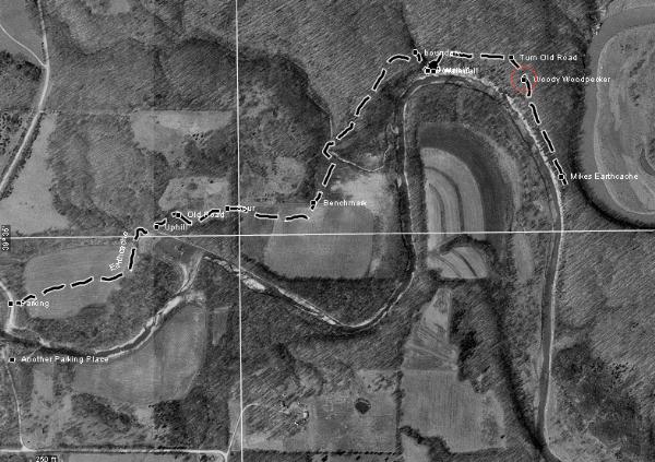
I parked at N39 34.915 - W091 56.383. Do not block the gate! There
is also parking on the other side of the creek as well. Enter in
the gate next to the parking coords I gave you. If you park on the
other side of the creek, you MUST cross the bridge and start at the
coords I parked at.
There is one area by the waterfall where you have a steep descent
and ascent to the other side. DO NOT CROSS ONTO PRIVATE PROPERTY!
In the waypoints, I have detailed the boundary of that
descent/ascent. It is not too difficult but not recommended for
small children.
The cache itself is a large pill container with a log. It can hold
small trinkets but do not leave travel bugs or coins unless you
want them to sit here for an extended period of time. Because of
the high terrain rating, I doubt that too many visitors will be
here during any given year. Please keep it tied to the log and
replace as you found it.
Make sure you visit the nearby Earthcache on top of the Narrows. It
is an awesome view.