Wenn Bochum und Umgebung mal wieder unter Schnee und Eis begraben liegen, ist das Cacherdasein schwer. So kam mir die Idee einen der Jahreszeit entsprechenden Earthcache zu kreieren.
 Beim Bau der Ruhr- Universität (1963-1965) wurden zahlreiche skandinavische Findlinge entdeckt, die bezeugen, dass das Bochumer Stadtgebiet während der Saaleeiszeit vom Inlandeis bedeckt war. Da die skandinavische Gesteine größtenteils nördlich der Ruhr auftauchen und die höchsten Geschiebe in einer Höhe von 150m gefunden wurden muss man annehmen, dass die Stiepeler Höhe (196m), der Kalwes (159m) wie auch eventuell der Bückenberg (150m) zumeist eisfrei waren.
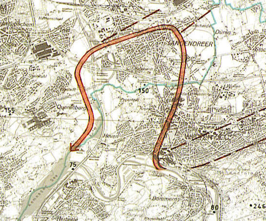
Zu dieser Zeit musste auch die Ruhr ihren Lauf verlegen, denn vorher lief sie aus heutiger Sicht von Wetter nach Witten und bog am Deutschen Edelstahlwerk nordwärts nach Crengeldanz ab, um in einer großen Schlinge über Langendreer westwärts zum Autobahnkreuz Bochum-Witten abzubiegen. Von dort folgte sie der A43 nach Süden und erreichte in Heven wieder das heutige Ruhrtal. Die direkte Verbindung von Witten nach Herbede bestand also nicht. Sie ist das Ergebnis des Eisvorstoßes, der den Bogen von Langendreer blockierte, weshalb die Ruhr sich einen neuen kürzeren Talverlauf suchen musste.
(Quelle: Herbert Liedtke 1980)
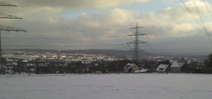
Wenn man bei den angegebenen Koordinaten am Stromgittermast auf dem Bückenberg steht kann man den alten Ruhrverlauf sehr gut verfolgen und vermeintlich überblickt man ein aktuelles Flusstal, da der Blick in das „neue“ Ruhrtal“ von dieser Stelle aus gar nicht möglich ist. Leider laufen über den Berg einige 110 KV Leitungen, so dass der schöne Blick etwas „verbaut“ ist aber cacher sehen die Welt sowieso mit anderen Augen !
Zum Loggen schickt mir eine mail an pitrun.bochum@freenet.de und beantwortet folgende Fragen.
1.) Wann endete die Saaleeiszeit
2.) Wie heißt das Tal heute, durch welches die Ruhr damals nach Umschlingung Langendreers wieder in ihr heutiges Bett zurückfloss.
3.) Welche vierstellige Nummer hat der Stromgittermast auf dem Bückenberg
Ein Foto von euch oder eurem Navi (nicht von eurem Hund oder unschuldigen Kindern) mit dem Ruhrtal oder dem Gittermast (bei schlechter Sicht) im Hintergrund wäre nett.
Logs ohne Foto sind neuerdings zulässig, aber weiterhin gerne gesehen. Logs werden nur gelöscht, wenn sie die Antwort enthalten oder wenn cacher absolut lernunwillig sind .
.
Bis dann pitrun
 Ice age in the Valley of the Ruhr
During the building of the university in Bochum (1963-1965) many scandinavian foundlings were found, which certificate that the city of Bochum was covered by ice during the Ice-age called Saale
Because the scandinavian stones were mostly found in the northern regions of the Ruhr and the highest boulders lies in an altitude of 150m, we can assume that the Stiepeler Höhe (196m), the Kalwes (159m) and also the Bückenberg (150m) are mostly iceless.
At this time the Ruhr must have been changed its riverbed, because from a present day perspective the river flows previously from Wetter to Witten and turn off at the Deutsche Edelstahlwerke in northern direction to Crengeldanz to turn off in a big loop about Langendreer to highway Crossing Bochum-Witten. From this point the river flows along the A43 in southern direction and reached at Heven the present valley of the river.
The direct connection from Witten to Herbede didn’t exist. It is the result of the ice-thrust, who blocked the loop of Langendreer, for what reason the Ruhr had to be found a shorter pathway.
If you are standing at the place of the coordinates under the lattice mast at the Bückenberg you can see the old river valley perfectly, so that you may believe that this is the actual river valley, because the new river valley can’t be seen from this point.
It’s a pity that many power supply lines leading across the hill, so that the nice view is not as beauty than thousands of years before, but cachers may see the world with other eyes !
To log permission you can send an e-mail to pitrun.bochum@freenet.de and answer the following questions
1.) When ended the ice-age of Saale
2.) What’s the name of the valley, which passed the river after the looping of Langendreer to flow back in the present river valley
3.) What´s the four-digit number of the lattice mast at the coordinates on the Bückenberg
After the receipt of the log permission you’ll stick a photo of you or of your navi (not from your dog or unguilty children) with the valley or the lattice mast (by miserabele sight) in the background.
Logs whithout photo are possible but they would be nice!
So long pitrun