CRIBYN EARTHCACHE (WBMC 11) EarthCache
CRIBYN EARTHCACHE (WBMC 11)
-
Difficulty:
-

-
Terrain:
-

Size:  (other)
Please note Use of geocaching.com services is subject to the terms and conditions
in our disclaimer.
The Brecon Beacons contains some of the most beautiful summits in Wales with graceful sweeping ridges and majestic cliffs but the upper slopes can be severe and testing in wet and windswept conditions. All the main summits except Cribyn have caches on them and this is such a fine peak it deserves at least an Earthcache – the first of mine to be dedicated to West Bromwich Mountaineering Club.
In 1957, the Brecon Beacons was the 10th area in England & Wales to be given National Park status. In October 2005, the Fforest Fawr Geopark situated within the Brecon Beacons National Park was awarded membership of the highly prestigious European Geopark Network and given UNESCO Global Geopark recognition. It is the 24th member of this UNESCO global network, the first Geopark in Wales and the first National Park in the UK to be so designated.
The Central Beacons dominate the skyline to the south of the town of Brecon and rise to 886 metres at Pen y Fan, the highest point in southern Britain. The landscape has been over 450 million years in the making, with the oldest (Ordovician) rocks found in a belt of country between Llangadog and Llandovery.
Around 60% of the area is made up of Old Red Sandstone rocks laid down in Devonian times (417-354 million years ago) but, in the southern part of the range, limestone and millstone grit predominate.
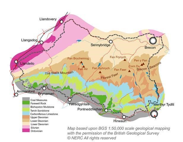
The rocks of the ‘Old Red Sandstone’ in the north, form the highest parts of the ranges and were laid down when the area lay within the arid interior of the giant continent of Pangaea. There was a huge Himalayan-size mountain range (the Caledonian) to the north which had been formed during the preceding Silurian period. This was eroded by great rivers during the Devonian and vast quantities of debris was carried southwards across what is now South Wales to be deposited as a succession of sandstones, mudstones and siltstones up to 3000 feet (900m) thick. Flat-lying then, these rock formations now dip gently southwards as a result of uplift, and now form the spectacular scalloped escarpment of the Brecon Beacons, Fforest Fawr and the Black Mountain. In the succeeding Carboniferous period, shallow tropical seas covered the more southerly parts of the area and it is here that the Coal Measures, the basis of the industrialisation of the Welsh valleys, were laid down.
Although these tilted rock layers give the basic shape to the hills, the landscape was finally carved into the shape seen today during the Ice Ages. From 2 million to 12,000 years ago glaciers filled the valleys of the Usk, Neath, Tawe and Cennen and rocks which were gouged out by the ice were deposited along the sides and bottoms of valleys, or randomly scattered across the upland landscape. The snow and ice collected on north-facing slopes of the mountains and developed into small glaciers.
All the hills in this range have distinctive flat tops and steep north-facing slopes, in which the sandstone outcrops as small reddish brown cliffs between the bands of sparse grass.
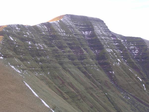
The cliffs of Pen y Fan
To claim this Earthcache you have to tell me how many of these outcropping sandstone bands you can see on the steep face of Cribyn as you look towards it from the ridge of Craig Cwm Cynwyn. You can see these well from the listing co-ordinates and also at N 51 52.672 W 003 25.113 where they stand out in the wall of a gully. It is still difficult to make out where one band starts and another finishes, however, so I will allow an error of up to 4 either way.
WBMC is a friendly club with members (aged 6 months to 85 years) mainly drawn from a 25 mile radius of West Bromwich. It runs monthly coach trips (normally to the Lake District or Snowdonia), hostel and bothy weekends, European trips in summer and a winter week in Scotland. The club has it’s own hut in Nantgwynant with all mod cons and organises and navigation skills and family weekends there several times each year. It meets 2nd & 3rd Thursdays at “The Red Lion”, All Saints Road, West Bromwich from 8pm (-ish) onwards. See www.westbromwichmc.co.uk for details of meets & events.
Additional Hints
(No hints available.)