Thorge - Störquelle / Störsource EarthCache
GeoawareDE8: Hallo,
da auf meine ReviewerNote vom 21. Juni 2018 nicht reagiert wurde, muss ich dieses Listing leider archivieren.
Mit freundlichem Gruß
GeoawareDE8
Hier findest Du Informationen zu den aktuellen Richtlinien:
Archivierung eines Caches
Wartung eines Caches
Richtlinien EarthCaches
Tipps der deutschen Reviewer
Thorge - Störquelle / Störsource
-
Difficulty:
-

-
Terrain:
-

Size:  (not chosen)
Please note Use of geocaching.com services is subject to the terms and conditions
in our disclaimer.
Ju yon
Thorge - Störquelle/Störsource
Die Stör (lat. Sturia) ist ein Nebenfluss der Elbe.
Ihre Quelle entspringt in Groß Kummerfeld, im Ortsteil
Willingrade.
Eine echte Quelle in dem Sinne ist nicht vorhanden.
Dennoch ist schon in Kleinkummerfeld der Bach so groß,
das er sich in Richtung Neumünster schlängelt.
Mit der Länge von 87 Kilometern gibt es in
Deutschland genau 101 Flüsse, die länger sind als die
Stör.
Ab Izehoe ist die Stör auch schiffbar
und somit für die letzten 51 Kilometer eine offizielle
Bundeswasserstrasse.
Schon ab Kellinghusen beeinflusssen Ebbe und Flut die
Wasserhöhe des Flusses.
Wie die meisten Flüsse in Schleswig-Holstein
fließt
auch die Stör über die Geest in das Urstromtal der
Elbe.
Die Entwicklung vieler Flüsse in diesem Gebiet
ist auf die letzte Eiszeit zurückzuführen,
die für die gesamte landschaftliche Gestaltung in
Schleswig-Holstein ausschlaggebend war.
So erreichte das Gletschereis in der so genannten
Weichseleiszeit
nur die Nord-Süd Ausdehnung von Flensburg über Rendsburg
gen Süden,
eine Grenze, die dem heutigen Übergang zwischen
dem Schleswig-Holsteinischem Hügelland und der Geest
entspricht.
Das Abschmelzen der Gletscher wusch das fruchtbare Land
westlich der Gletschergrenze frei,
es blieb daher der in vorigen Eiszeiten entstandene
Geestrücken (Endmoränen) zurück.
Diese waren sandig und unwirtschaftlich,
woher auch der Name Geest rührt.
Im Osten blieb beim Abschmelzen der Gletscher das Material,
das die skandinavischen Gletscher trugen,
als Hügellandschaft zurück.
Aufgrund dieser geologischen Gegebenheiten fließen auch heute
noch die meisten Flüsse
in Schleswig Holstein in Ost-West Richtung, prinzipiell durch die
drei in Schleswig Holstein
vorherrschenden Landschaften: Hügelland, Geest und
Marsch.
Für das Loggen des Caches müsst Ihr folgende Aufgaben
lösen:
1.In welchem Jahr wurde das Störsperrwerk an der
Elbmündung erbaut?
2.Bis zu welchem Flusskilometer reichen die Auswirkungen von Ebbe
und Flut
3.Welchem Krenal ist die Stör zuzuordnen? (Gesucht wird der
griechische Fachbegriff!)
4.Seid kreativ.
Baut ein Model der drei Landschaften in Schleswig-Holstein mit
mindesten einem Flusslauf im Model.
5.Ladet ein Bild eures Models mit euerem Log hoch.
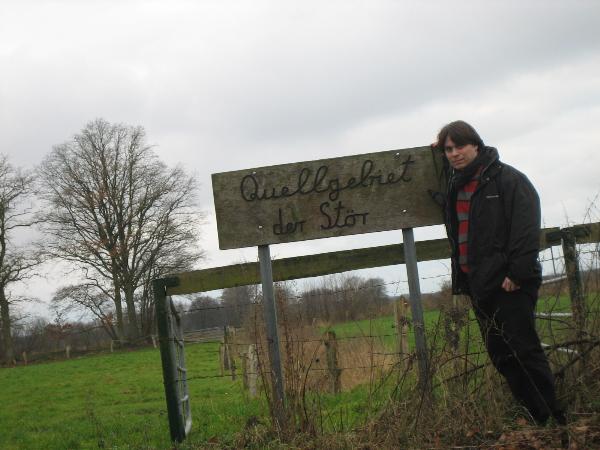
6.Bitte macht ein Foto von euch am Schild „Quellgebiet der
Stör“ und ladet dieses mit eurem Log hoch! Darauf
müsst Ihr zu sehen sein.
Logs mit Zeichnungen anstelle eines Models werden nicht
akzeptiert.
Bitte sendet eure Antworten zu dem Fragen vorab an mich und wartet
auf eine Freigabe per mail, bevor ihr den Cache loggt.
The river Stör (lat. Sturia) is a tributary stream of the
river Elbe.
Her spring is in Groß Kummerfeld, in the district
Willingrade.
A real spring doesn't exist.
But nevertheless, in Kleinkummerfeld the flow of the river has
increased,
so that it is winding towards Neumünster.
With a length of 87 kilometers,
there are exactly 101 rivers in germany which are longer.
From Izehoe, shipping is possible, so that for the last 51
kilometers, the Stör
is a official federal water highway.
From Kellinghusen, the tide is influencing the water-level of the
river.
Like most of the rivers in Schleswig-Holstein, the Stör flows
over the Geest
into the glacial valley of the river Elbe.
The sources of many rivers in this country is based upon the last
glacial age,
which has been important for the appearance of the landscape in
Schleswig-Holstein.
The glacial border reached in the so called „Weichsel“
glacial age
a line drawn from North to South from Flensburg over Rendsburg
further south.
Today, this border represents the border between the Geest
and
the Schleswig-Holsteinischem hilly country.
The ice melt of the glaciers washed away the fruitful earth
west of the glacial border, so that only the remains of the last
glacial age,
the Geestrücken, a terminal moraine, remained.
This land was sandy and meager, therefore it was called
„Geest“ (unfruitful).
East of the glacial border, matierial carried by the scandinavia
glaciers was set free and formed a hill landscape.
Due to these geological circumstances, most of the rivers in
Schleswig-Holstein
flow from east to the west, generally throught the three main
landscapes in Schleswig-Holstein:
Hills, Geest and Marsch.
To log this cache, you have to fulfill the following quests:
1.What is the year in which the stör barrier
(„Störsperrwerk“) was built?
2.Up to which riverkilometer is the tidal influence noticeable
?
3.What kind of source has the Stör ? (The answer is a greek
word.)
4.Be creative.
Build a model of the tree mentioned landscapes in
Schleswig-Holstein in the right order with at least one course of a
river included in the model.
5.Post a picture of this model within your log.
6.Please take a picture of you in front of the sign
„Quellgebiet der Stör“ and upload it with your
log!
You have to be visible in the picture.
Logs with drawings instead of a model will be refused.
Please send the answers to the above questions to me and wait for
my approval prior logging this cache.
Additional Hints
(Decrypt)
Gb nafjre D4: Eurbxera (fcevat fbhepr) Urybxera (fjnc fbhepr) Yvzabxera (cbby- be pbar fbhepr)