
Deutsch
Der Geopfad ist ein 10km langer Wanderweg durch Wuppertal-Barmen. Auf wenigen hundert Metern kann man hier 10 Millionen Jahre geologische Geschichte erleben.
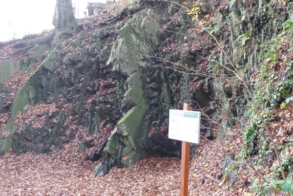
Der Devonische Boden zeigt, mit welcher Gewalt der devonische Meeresboden durch die Afrikanische Platte bei der variskischen Faltung gestaucht und gefaltet wurde. Der ursprüngliche ebene Meeresboden fällt jetzt steil nach Norden zur Herzkamper Mulde ein. Der Plattensandstein (to2s), oberste Schicht der Nehdenstufe, bildet den Härtlingsrücken des Nordparkes. Die Schichtunterseiten weisen Strömungsmarken, Trockenrisse und Kriechspuren oberdevonischer "Tiere" auf.
Um diesen Earthcache zu loggen ...
1. ... finde heraus, wie hoch die Wand ungefähr geschätzt ist
2. ... finde heraus, welche Tiere hier ihre Spuren hinterlassen haben
3. ... mache ein Foto von dir und deinem GPS vor der Wand. (!!!freiwillig!!!))
Sendet mir bitte die Antworten der Fragen, um diesen Earthcache loggen zu dürfen!
Logs zu denen keine Antworten per Mail vorliegen, werden gelöscht.
Ihr dürft nach dem Versenden der Mail sofort loggen!
Bitte nicht über das Message Center kontaktieren, sondern über diese Mail-Adresse:
earthcache.gc.bb10@gmail.com
Happy Caching wünscht bb10
English
The Geo-Path is a 10 km long hike trough Wuppertal- Barmen. If you walk on the path you can walk past in a few hundred meters more than 10 Million years of geology.
The Devonian ground is an exposure which shows us how much the Devonian Sea bottom was compressed by the African plate. The original flat sea bottom is now rampant to the north. The sandstone (to2s), top deposit of the "Nehdenstufe" builds the ridge of the Northpark. The lower part of this layer shows branded, desiccation cracks and creep-tracks of upper devonian "Animals"
To log this Earthcache ...
1. ... estimate how high the wall is
2. ... find out what kind of Animals have left there tracks here
3. ... take a photo of you and your GPSr in front of the Wall (! voluntarily!).
Please send me the answers to this eartcache per mail. Any logs without an e-mail will be deleted.
You can log immediately after sending the mail.
earthcache.gc.bb10@gmail.com
Happy Caching wishes you bb10