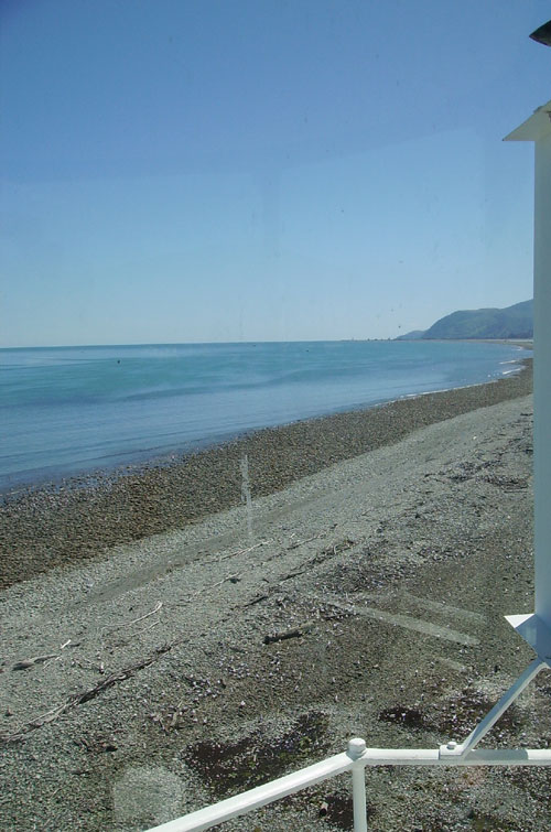
View towards Mackay Bluff (the source) from the
lighthouse.
Geology
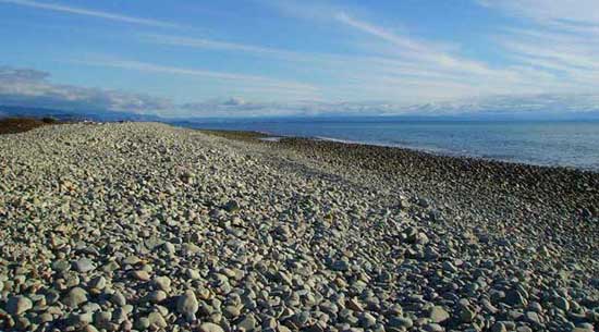
The Boulder Bank is a natural reef made of granodiorite
(an intrusive igneous rock similar to granite), more specifically:
cable granodiorite, and through continuous action by the sea’s
waves are shaped into smooth boulders, the largest being about 1.2m
in diameter, and in average around 20cm. The sea continually
hitting this natural barrier slams the boulders together, further
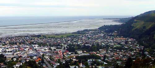
shaping this bank which has produced a natural harbour for Nelson
(Nelson Haven). The Boulder Bank is the largest natural reef in the
Southern Hemisphere. The rocks in the bank are thought to have come
– by most researchers - from the Mackay Bluff and Peppin Island at
the Northern end over a period of approximately 6000 years. A
minority of scientists, such as Dr Warren Dickson at Victoria
School of Geography, Environment and Earth Sciences propose that
the wave action isn’t sufficient to account for the movement of
rocks from the point of erosion at Mackay Bluff along the bank, and
suggests the rocks may be eroded from the nearby sea floor. The
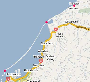
Bank is approximately 6m above mean sea level and stretches for
13km from Mackay Bluff in the North to The Cut in the South. The
Cut is a man-made entry through the bank into Nelson Haven, which
is 50m wide at low tide. During the ice ages 12,000 years ago the
Tasman Bay seabed was dry. Rocks falling off Mackay Bluff, part of
the Flaxmore Fault, collected in a fan below it. When the ice
melted 9,000 years ago the sea level rose steadily and eroded the
boulders out of the fan. The boulders and associated debris were
carried South forming the Bank - a process that continues to this
day. The top of the Bank is migrating Eastward leaving a succession
of ridges behind it.
Ecology
Despite its robust appearance, the Boulder bank is a delicately
balanced habitat for rare species of plants and animals. In
addition, it is a nesting place for colonies of gulls, and a
resting place for seals and dozens of species of coastal migratory
birds including the Variable and South Island Oyster Catchers. At
least once every few years, the Boulder Bank is the final resting
place for a whale, dolphin, squid or other sea creature which
automatically become a source of further research.
Access
The coordinates of this Earth Cache take you close to the source
of the Boulder Bank near Mackay Bluff and an information sign
that holds the answer to the logging question. From this point
you have immediate access to the Boulder Bank, and if you want,
quite a long walk along the length of it to the lighthouse (13km)
which is the 2nd oldest permanent lighthouse in New Zealand (after
Wellington’s Pencarrow Lighthouse). The Bank at this stage is still
part of the mainland. Alternatively, make your way to S 41° 13.023
E 173° 19.802 and take Boulder Bank Drive to S 41° 12.184 E 173°
19.401, where you can park and access the Boulder Bank also. From
here the walk to the lighthouse is approximately 2-3 hours one-way
(8km), and it is also where the Boulder Bank spit starts, which
encloses Nelson Haven. You can also access the Southern end of the
Boulder Bank by kayak or boat. A ferry service is available which
can take you to the Boulder Bank and Haulashore Island at times,
duration and in a sequence you yourself request. (Contact:
Haulashore island Ferry, Wakefield Quay, Ph 027 437 5259 – fee
payable). Using this ferry service also gets you access to a key
which allows you to enter the light house (December 2008).
History
The Boulder bank has a natural opening at its Southern end, near
Arrow (Fifeshire) Rock. This opening is quite narrow and, as can be
seen at low tide, has sharp rock jutting from the sea floor making
this entry into Nelson harbour quite treacherous. Countless vessels
were damaged here. So in 1906, a new entrance to Nelson Haven was
blasted into the Boulder Bank, producing two new distinct features:
The Cut (the entrance) and Haulashore Island, which used to be the
Southern-most tip of the Boulder Bank. The shelter offered by the
Boulder Bank was a major factor in choosing the site of Nelson. In
1848 a beacon was erected near the end of the bank. Across The Cut
from Haulashore Island you find the white iconic cast iron
lighthouse that replaced the beacon. It was originally established
in 1862, automated in 1915, and operated as recently as 1982. Only
the grounds around the lighthouse are accessible to the public,
although the lighthouse is accessible by arrangement with Port
Nelson Ltd. During the Second World War, in 1942, the lighthouse
light was extinguished due to the perceived threat of a Japanese
invasion. The light was re-established in May 1943. There are six
permanent batches (cribs/shanty holiday homes) on the Boulder Bank.
Controversy ensues each time the (Government) Department of
Conservation (DOC) suggests they should be removed to return the
Bank to its “natural state”, but to locals, their presence is as
natural as the Bank itself, and thus far DOC has failed to achieve
their aim of returning that part of the Boulder Bank to its natural
state. The Cut is periodically dredged as sand and and boulders
continue to build up.
Logging requirements
DO NOT LOG THIS CACHE UNTIL YOU RECEIVE
APPROVAL BY EMAIL. Send an email to
geocachingnz.@
.gmail.com with the following information:
name the process that has created the Boulder Bank. Also email a
photo of yourself holding your GPSr and the Bank clearly visible
behind you.
Further information
Nelson Boulder Bank, New Zealand
M. R. Johnston
New Zealand Journal of Geology and Geophysics, 2001, Vol. 44:
pp79-88
Available as a PDF from here:
http://www.rsnz.org/publish/nzjgg/2001/8.php
Owners Value Ageing Harbour Icons
NZ Historic Places Trust,
Summer 2003 issue
Available online from here:
http://www.historic.org.nz/magazinefeatures/2003summer/2003_summer_boulderbank.htm
Art. XXVI.—On the Nelson Boulder Bank.
W. F. Worley.
Transactions and Proceedings of the Royal Society of New Zealand,
1899, Vol 32: pp221-225
[Read before the Nelson Philosophical Society, 13th November,
1899.]
Available as a PDF from here:
http://rsnz.natlib.govt.nz/volume/rsnz_32/rsnz_32_00_003640.htm
The Historic Places Trust Register
Boulder Bank Lighthouse
Register Number: 41
Registration Type: Historic Place - Category I
Date Registered: 23/06/83
http://www.historic.org.nz/Register/ListingDetail.asp?RID=41&sm=

Maori history
(Entry below provided by isis58 in her log. Asked and received
permission to make it part of the permanent cache page so when the
log no longer appears on the cache page, this valuable and
interesting information is retained for others to read.) -
"This [earth cache] has a very long cache description but three
other important viewpoints about the process on how the Boulder
Bank was formed have been overlooked. First is how Kereopa who was
being persued by Kupe, after kidnapping one of his daughters,
offered karakia (incantation, prayer, blessing, ritual chant) which
caused the boulders at Horoirangi (Mackay's Bluff) to begin to move
and form a barrier, so no matter how hard Kupe's crew paddled the
Boulder Bank also grew and in the end they abandoned their chase.
Another is about Tu Ariki who put a strange looking fish called
Tutaeporoporo (which turned out to be a taniwha (monster)) into a
deep pool at Whakatu (Nelson). As it grew from his daily feedings
it enlarged the pool and moved the rocks and boulders and created
the Haven and the Boulder Bank - the legend continues but isn't so
relevant to this cache. The other claim is the Chief Te Maia, a
tohunga (skilled person, chosen expert, priest), arrived and could
find no safe place to anchor his canoe so walked up to the port
hills and performed certain rites and said karakia to give the bay
a harbour. He then went home to the north and when he and his hapu
(subtribe) returned they entered, past the rock into what they
considered the perfect harbour. Each of the 4 [descriptions] has a
plausible explanation given your point of view." Citation:
Hilary and John Mitchell - Te Tau Ihu o Te Waka
Contemporary events
To many people, the Boulder Bank is just a ridge of boulders
that lies there, and nothing much is going on. This is somewhat
deceiving.
Restoration work is currently underway to return the lighthouse
to operating condition. A special bulb is being sourced and soon
Nelson’s naval sentinel will be back in operation. (December
2008)
A privately owned research company, the Cawthron Institute, has
gained permission (Resource Consent) to build a direct road to the
Boulder Bank (September 2008) to gain access to their Glenhaven
aquaculture site at the Northern end. Cawthron had originally
intended to build a road adjacent to the Boulder Bank but failed to
gain resource consent after concerns were raised about possible
environmental and landscape damage.
Just before Christmas 2007, a man in a kayak, who was quite
drunk at the time, climbed Arrow (Fifeshire) Rock to remove the
lone wild native Cabbage Tree (Cordyline australis/ Ti
kouka) as a prank. This caused two quite separate responses. One
was some legal hand wringing as to who exactly has legal ownership
of the Southern-most feature off the Boulder Bank, and would
therefore be the entity to lay a complaint against the trespasser.
All that was established was who was not the owner,
including Nelson City Council, the Harbour Board, and the
Department of Conservation. Before this administrative matter could
be settled, the significant public outcry against the prankster was
so severe, that with genuine remorse (and by now quite sober) “the
tree butcher” had returned to plant a replacement Cabbage Tree on
the rock. The public were concerned that the domestically
cultivated tree would not withstand the exposed conditions, but one
year later, it seems to be flourishing.