All sand dunes are somewhat similar. They all need sand, water,
a space to form, and they are all constantly changing. However,
each sand dune is different in its own way. Each sand dunes' shape
is determined according to how much sand and what kind of sand is
available to be blown into dunes. The direction of the wind is also
essential. A sand dune can be as small as an anthill or as tall as
a skyscraper. All sand dunes are formed the same way, every single
one is a pile of sand built up by the wind. Once the sand has been
picked up by the wind, it will go wherever the wind carries it.
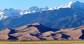
These dunes were formed from sand deposited by the Rio Grande and
its tributaries, which flow through the adjacent San Luis Valley.
For thousands of years, prevailing westerly winds have blown over
the Rockies and down over the river flood plain, picking up sand
particles on the way. These are then deposited at the east edge of
the valley before the wind rises to cross the Sangre de Cristo
mountains. The process continues and the dunes are still being
gradually enlarged by the wind, which also changes the shape and
sand patterns of the dunes daily. In some places, patches of black
sand are found caused by deposits of magnetite, a crystalline black
oxide of iron. This is one place where footprints are definitely
not a problem, unlike many desert parks of the Southwest where the
delicate sandy soil is easily damaged by visitors. We are going to
study the effects of the wind on this portion of the dune. Is the
dune getting smaller or is it growing right now? As you log this
cache you will be helping with the study.
4 Logging requirements.
1 Go to the posted coord and get your picture with your GPS in
hand; then post the picture in your log
2 You must also record and post your elevation reading in that
location.
3 Tell us if the dune is growing or shrinking in that exact
location since the last logged visit. I will start this off with a
current elevation reading of 8,682 feet.
4 - Your final task will be to research sand dunes and email me the
type of sand dune you are visiting.