 Le château est sur la commune de Mello 60660. Mello compte 412 habitants pour une superficie de 335 hectares. Elle fait partie du Canton de Montataire et de l'Arrondissement de Senlis. Les habitants de Mello sont les Merlouquins. Mello était le chef-lieu d'une des plus anciennes seigneuries du Beauvaisis, englobant Mello, St-Vaast,Maysel, Cramoisy, Cires et Rousseloy. C'était une baronnie de coutume qui conférait le titre de baron à ses propriétaires.
 The castle is on the town of 60660 Mello. Mello has 412 inhabitants and an area of 335 hectares. It is part of Canton Montataire and the District of Senlis. The inhabitants of the Merlouquins Mello. Mello was the chief town of one of the oldest seigneuries Beauvaisis, including Mello, St. Vaast, Maysel, Cramoisy, Cires and Rousseloy. It was a custom of barony which conferred the title of baron to its owners.
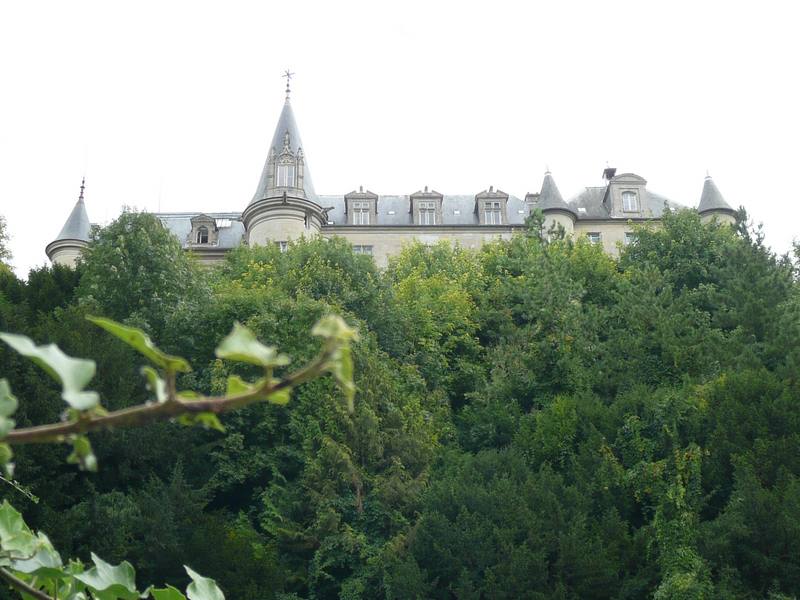
Situé sur le haut du coteau, le château flanqué de tours et tourelles, fut bâti en premier lieu par les Dreux de Mello. Rebâti en 1480 par Louise de Neelle, reconstruit en 1770 par les Montmorency et restauré au XIXeme. Le connétable de Dreux de Mello y mourut en 1218. Un gros donjon de 25 mètres de haut fut rasé au XIXeme. Plusieurs tours secondaires restaurées, dont l'une enferme la chapelle, animent la composition. Quatre plus petites datent du XVeme. Une collection d'Arts et Antiquités a été rassemblée par ses différents propriétaires. Henri IV y séjourna trois jours en 1598. Dans le parc, la chapelle Saint Anne, but d'un pèlerinage annuel du même nom. Mello fut acheté au XVIIIeme par Pattu de Mello, dont on garde dans la bibliothèque l'herbier avec annotations de célèbres botanistes. Après la Révolution, ce fut le baron Seillière, banquier, dont la commune a été l'objet de sa largesse. Il meurt à Mello en 1856. Aujourd'hui, c'est la propriété de la comtesse de Boissieu-Durfort.
Located on the top of the hill, the castle flanked by towers and turrets, was built primarily by Dreux de Mello. Rebuilt in 1480 by Louise de Neelle, rebuilt in 1770 by the Montmorency and restored in the XIX. The constable of Dreux de Mello died in 1218. A huge tower of 25 meters high was demolished in the XIX. Several rounds secondary restored, one of which encloses the chapel, the membership drive. Four are from the smaller XVeme. A collection of Arts and Antiques was collected by its various owners. Henri IV stayed three days in 1598. In the park, the Chapel of St. Anne, but an annual pilgrimage of the same name. Mello was bought by the XVIIIth Pattu de Mello, which is kept in the library with the herbarium annotations famous botanists. After the Revolution, it was Baron Seillière, banker, which the town has been the subject of his largesse. He died in 1856 at Mello. Today, the property The Countess of Boissieu-Durfort.
Vous êtes prêts .... c'est parti. / You're ready .... here we go.
Les indices à trouver pour vos calculs s'étalant de A à L,il est conseillé de vous munir d'une calculette.
The clues to find your calculations ranging from A to L, it is advisable to bring a calculator.
WayPoint 1
Après un peu d'histoire, cette multicache débutera près de la maison de la randonnée et la gare de Cires les Mello village proche.
Garez votre véhicule sur le parking aux coordonnées suivantes :
49° 16.323'N et 02° 21.629'E
puis cherchez le monument commémoratif des 2 guerres qui est le départ de votre énigme.
WayPoint 1
After a bit of history, this multicache begin near the house of the hike and waxes station near the village Mello.
Park your car in the parking at the following address:
49° 16,323'N and 02° 21,629'E
then look for the memorial of war 2 which is the departure of your puzzle.
WayPoint 2
Le long de ce parking vous trouverez le monument commémoratif des 2 guerres. Sur la face Est, côté porte drapeaux, 2 dates sous l'inscription "victimes civiles" soit "A" et "B".
Sur la face Ouest, du côté du casque bleu, des inscriptions en haut, au milieu, et sur le socle. Prenez en compte les 2 dates du milieu, soit "C" et "D".
Vous allez vous rendre au waypoint 2 en calculant ceci :
49° 16,(A+B-3551) Nord et 02° 21,(C+D-3068) Est
Ces coordonnées vous emmènent dans un petit jardin donné par le Baron Frank SEILLIERE.
WayPoint 2
Along this terminal you will find the memorial 2 wars. On the eastern front, side door flags, 2 dates in the inscription "civilian victims" either "A" and "B".
On the west side of side of the blue helmet, labeled the top, middle, and the socle. Consider the 2 dates of the middle or "C" and "D".
You will get to the waypoint 2 calculating this:
49° 16, (A+B-3551) North and 02° 21, (C+D-3068) East
These coordinates take you to a small garden by Frank Baron SEILLIERE.
WayPoint 3
Dans ce jardin, une stèle commémorative. Sur celle ci 2 dates soit "E" et "F".
Vous allez vous rendre au WayPoint 3 en calculant ceci:
49° 16,(F-E+213) Nord et 02° 21,(E+F-2875) Est
Ces coordonnées vous emmènent au lavoir de Mello.
Une fois devant, et à peu près dans la direction de l'Est une vue magnifique du château.
WayPoint 3
In this garden, a commemorative stone. 2 dates to take into account "E" and "F".
You will find the WayPoint 3 by calculating the following:
49° 16, (F-E+213) North and 02° 21, (E+F-2875) East
These coordinates take you to washhouse of mello.
Once before, and roughly in the direction of the East a magnificent view of the castle.
WayPoint 4
A l'intérieur du lavoir une pancarte, également visible de l'extérieur si celui-ci est fermé. Si votre vue est défaillante, faite le tour du paté de maison et la même pancarte est disponible à l'entrée de la sente menant à ce lavoir.
Sur cette pancarte des heures de fermeture Hiver/été sont inscrites, ainsi qu'une date de décret.
Les horaires d'hiver sont de 9 heures à "G" heures "H" et les horaires d'été sont de 8h30 à "I" heures "J".
Vous allez vous rendre au WayPoint 4 en calculant ceci:
49° 16,(G+H+298) Nord et 02° 21,(I+J+805) Est
L'année du décret sera "K".
Ces coordonnées vous emmènent devant "la Maison aux Os". Etrange maison où sont plantés sur les murs, de part et d'autre, entre les pierres, des Os.
Selon la légende, ces os étaient mis en place par un maçon de la région afin d'absorber l'humidité entre les pierres.
L'os faisant office de "déshumidificateur".
WayPoint 4
Within the washing sign, also visible from the outside when it is closed. If your eyesight is failing, made around the block and the same sign is available at the entrance to the present leading to the wash.
On this sign of closing hours Winter / Summer are listed, and a date of decree.
Winter hours are 9 hours to "G" hours "H" and hours of summer are from 8 hours 30 to "I" hours "J".
You will find the WayPoint 4 by calculating the following:
49° 16, (G+H+298) North and 02° 21, (I+J+ 805) East
The year of the decree will be "K".
These coordinates take you to "House to bones". Etrange house are planted on the walls on both sides, between the rocks, the bones.
According to legend, the bones were put in place by a mason in the region to absorb moisture between the stones.
The bone to act as "dehumidifier".
Waypoint Final
Dans la ruelle, sur la partie la plus basse de la maison aux os, juste sous la gouttière à gauche, une date.
Le troisième chiffre étant ambigu, nous allons jouer avec le 1er, le 2ème et le dernier.
Additionnez ces 3 chiffres ensemble pour obtenir "L".
Vous allez vous rendre au WayPoint final en calculant ceci :
Latitude Nord = 49° 16, ( (J x L) - (F - C) - (I - L - 1) )
Longitude Est = 02° 22, ( (J x G) - (K - E) - (C - E + G + 1) )
Ces coordonnées vous emmènent au WayPoint final d'où vous pourrez découvrir la cache.
Final Waypoint
In the alley, on the lower house of bones, just below the gutter on the left, a date.
the third being ambiguous, we will play with the 1st, 2nd and last.
3 Add these figures together to get "L".
You will find the FINAL WayPoint by calculating the following:
North Latitude 49° 16, ( (J x L) - (F - C) - (I - L - 1) )
East Longitude 02° 22, ( (J x G) - (K - E) - (C - E + G + 1) )
These coordinates take you to final WayPoint. End point where you can discover the cache.
Pour vous rendre au WayPoint Final, prenez le chemin qui va en direction du hameau de Barisseuse et admirez en passant aux cordonnées :
49° 16,575 Nord et 02° 22,280 Est, l'ancien ermitage du Château de Mello.
Vous l'apercevrez moins bien en été à cause des feuillages. ATTENTION il est interdit au public.
To get to the Final WayPoint , take the road that goes towards the hamlet of Barisseuse and enjoy passing the coordinates:
49° 16,575 North and 02° 22,280 East, the former hermitage of the Chateau de Mello.
You see worse in summer because of foliage. ATTENTION it is prohibited to the public.
Le trajet aller/retour est d'environ 4 kilomètres. Bonne promenade.The ride round trip is about 4 kilometers. Good walk.