Please observe and obey the signs that are posted on or before April 15th through August 15th or later. The signs warn of areas that are off limits during the nesting season of shore birds.
A spit is a deposition land form found off coasts. At one end, spits connect to land, while at the far end they exist in open water. A spit is a type of bar or beach that develops where the shoreline changes direction by 30 degrees or greater.
Spits start by the process of longshore drift. Longshore drift (or littoral drift) occurs due to waves meeting the beach at an oblique angle, and back washing perpendicular to the shore, moving sediments down the beach in a zigzag pattern. Longshore drifting is complemented by longshore currents, which transport sediment through the water along the beach. These currents are set in motion by the same angle of the waves that causes littoral drift and transport sediment in a similar process.
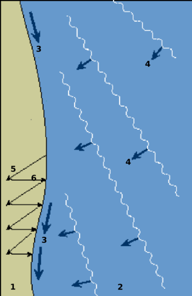
The water that washes up on shore after an incoming wave has broken is call Swash. To understand swash better we'll break it down to it's two parts. The first is the up rush or the water that washes up on shore after an incoming wave has broken. The direction of the swash varies with the prevailing wind. The second is the backwash or the water that flows back to the lake. This flow is always perpendicular to the shore.
When waves approach the coastline at an angle, they break and their swash pushes beach material up the beach at the same angle. The backwash then drags the material down the beach perpendicular (at a 90º angle) to the shore, following the line of the steepest gradient. This produces a zigzag movement of sediment along the beach known as longshore drift.
The energy created from the breaking waves allows for weak currents to carry large amounts of coarse-grained sediment down the shoreline. These weak currents, known as longshore currents, carry water and sediment parallel to the shoreline toward the down drift end of the beach.
A change in prevailing wind direction often causes the end of spits to become hooked (also known as a re-curved lateral). On the spit itself, sand dunes often form and vegetation colonizes. Water is trapped behind the spit, creating a low energy zone, as the water begins to stagnate, mud and marshland begins to develop behind the spit. Spits may continue to grow until deposition can no longer occur, for example due to increased depth, or the spit begins to cross the mouth of a river and the water removes the material faster than it can deposited, preventing further build up.
In the case of the Tawas Bay Spit, the longshore drift moves material from the north to the south. As the shoreline turned sharply to the west, this change in the coastline caused a loss of energy to transport the sand along the now east-west shoreline. Sand would now form the spit across Tawas Bay.
As can occur the spit at Tawas Bay has formed sand dunes that have become vegetated. Please take care when walking on the spit. It's a fragile environment so please stay on the trail or the open beach.
Tawas Point has been referred to as the "Cape Cod of the Midwest." The campground is located on Tawas Bay where the water is shallow and warm for swimming. In the park is the Tawas Point Lighthouse which serves as the sole representative of a true Victorian-era style station on the Great Lakes.
A vehicle permit is required to enter Tawas Point State Park. The park offers hiking trails, wildlife viewing areas, fishing, picnic areas, playground, sandy beaches among other features. Also located inside the park is a lighthouse built in 1876. The lighthouse stands 70 feet above Lake Huron. The Coast Guard station adjacent to the park on Lakeview Drive was also built in 1876 and is the only surviving example of the First Series Life Saving Stations built on the Great Lakes.
To be able to understand the formation of a spit the third logging requirement is important. If there is ice on the Lake Huron side of the spit then you can not complete the logging requirements of the earthcache. Over the past several years little ice has built up on the Lake Huron shore. I will not disable this earthcache during the winter as the shore could be free of ice.
Logging requirements for this earthcache are:
1. At the posted waypoint take a picture of yourself with your GPS. This picture is optional and is not required.
Send me an email, through my profile with the answers to the following two requirements. Do not post this information in your log.
2. Find your way to the Lake Huron side of the spit and walk to were the waves are breaking on the shore. Observe the movement of the sand. Report to me the direction of the movement, as in north to south or south to north. If the area is closed to protect the nesting birds, then report this to me.