Malvern Springs EarthCache
-
Difficulty:
-

-
Terrain:
-

Size:  (other)
Please note Use of geocaching.com services is subject to the terms and conditions
in our disclaimer.
Springs that flow from the lower slopes of the Malvern Hills in Worcestershire that in the past have provided fresh drinking water to several towns and villages.
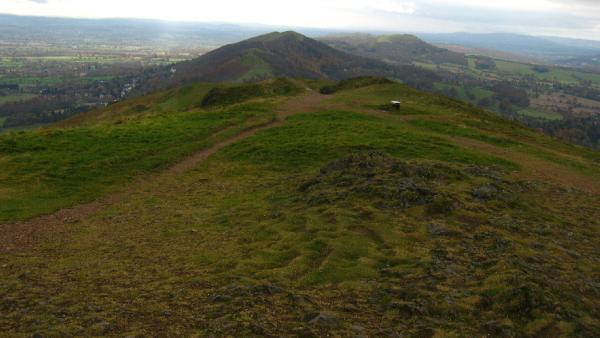
The Malvern Hills are a range of hills set in the Severn Plain known world-wide for their natural spring water. The range of hills is some nine miles long with the highest point, on the Worcestershire Beacon, standing at 426 metres high. The main ridge is made up of 600-800 million years old Pre-Cambrian Igneous Rock, probably some of the oldest in the UK. The rock was formed during sub-oceanic volcanic eruptions from the long period of time before there were any fossils. To the east are younger Triassic Rocks and to the west the Silurian Sea formed layers of limestone about 300-400 million years ago. The limestone layers can clearly be seen in quarries between Malvern and Ledbury. The photo below shows part of the ridge, from the top of the Worcestershire Beacon, southwards with the plain stretching on either side and beyond.
Huge geological upheavals and tectonic events some 300 million years ago caused many folds and faults in the ridge. It is these faults that give rise to the springs in this area. Although granite is impermeable, the many fissures allow water to seep through the rock where it collects to emerge directly from faults/fissures in the rock further down the slopes. The average annual rainfall in the area is around 650 to 700 mm. This rain filters through the many fissures and faults to emerge directly from the fissures in the Pre-Cambrian rocks. These rocks have a low solubility and water from these is reputed to be exceptionally pure due to their low mineral content and the filtering effect of the water flowing such a great distance through the rocks so are ideal for drinking. We tend to think of bottled water as a modern trend but water was being bottled from the Holy Well in the early 17th Century! There are over 60 known wells and springs within the Malvern Hills Area and most are detailed at the following website - Malvern Springs
We have nominated two springs for your visit which are quite close together….
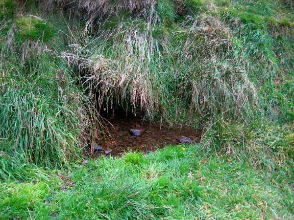 Dingle Well at N52 06.503 W002 20.473...can be found as a completely natural spring flowing from a hole in a grassy bank on the Worcestershire Beacon, which then runs into a pipe which diverts the water to come out in the bank just below the West Malvern Road. Originally this spring was the sole water supply for all the houses in the valley. The last house to totally rely on this spring for it's water supply was demolished around 2001.
The other site, as with many of the springs, no longer appears as a natural spring.
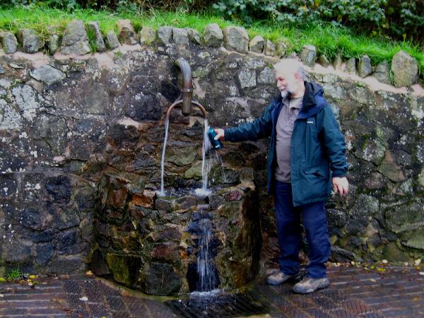 This is Hayslad at N52 06.163 W002 20.651 .Here there is always a good flow of water as more than one spring have been combined to flow from this single spout. The water is very pure and completely safe to drink. This is the most popular site for people to come to collect their own water as there is space to park a few cars opposite the well. Unfortunately, as this is so popular there are often queues of people waiting to fill their containers.
Permission has been obtained from the Malvern Hills Conservators to publish this listing but they ask to be informed of any large groups who wish to visit. Visits by individuals or family/small groups are exempt from this.
We recommend that you park at the Pay & Display car park at West of England Quarry at the co-ordinates listed above. From here you are within 200 metres of Hayslad and less than 1.5 Km from Dingle Well. The Parking Fee ( currently £2.00 for all day) will go toward the upkeep and maintenance of the springs, woodland and pathways of the area. The best route from here to the Dingle Well is to follow the road Northwards to West Malvern. Just opposite "The Brewers Arms" a bridleway leads up hill off to the right. At the end of the paved road a track leads to the Well. If feeling energetic you could continue up this path which leads to the top of the Worcestershire Beacon with it's magnificent views and you can find a conventional cache - Three Counties View - (GCRQ9W) near the top. If you don't want to walk the whole distance there is some limited parking near to the Bridleway at N52 06.497 W002 20.681 but is likely to be full at peak visiting times.
In order to claim this earthcache you'll need to submit the following...
A photo of you and/or your GPS device, at either of the wells, uploaded to the visit log if you wish to. Answers to the questions detailed below - these are a must. You don't need to wait for a reply and may not even get one if we are too busy but we will contact visitors without answers being sent and the logs will be deleted if they are not complied with
1 – At Dingle Well what is the direction of flow from the hole in the grass bank – not "down hill" ! - the bearing in degrees which you should be able to get from the compass on your GPS device if you don't own a normal compass. If the water doesn't seem to be flowing assume that it is flowing directly out of the hole in the bank.
2 – How many individual springs have been combined to run from the spout at Hayslad?
Additional Hints
(Decrypt)
Gur yvax va gur yvfgvat jvyy uryc lbh jvgu dhrfgvba 2 !