Moucné pytle
Flour Bags - Mehlsäcke
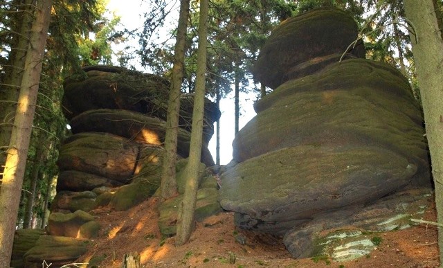
[CZ] Prírodní pamáka Moucné pytle se nachází na jižním zalesneném svahu Jeleního vrchu (643 m.n.m.), v blízkosti turistické cesty protínající Kozí hrbety od Doubí u Karlových Varu po Loket. Skalní útvary Moucných pytlu jsou typickým príkladem mrazového srubu vzniklým blokovou odlucností pri zvetrávání žulového vrcholového skalního výchozu. V podobném rozsahu a tvaru není na území CHKO Slavkovslý les známá obdobná prírodní pamáka. Scenérii dominuje cca 5 metru vysoká skalní vež rozclenená svislými i vodorovnými puklinami na útvary žokovitého vzhledu - pytle. Nazev Moucné pytle vznikl celkem prozaicky z legendy, podle které jsou Moucné pytle zkamenelý naklad lakomého sedláka.
Výchozí souradnice vás dovedou na prekrásnou vyhlídku na Jelením vrchu. Cílové místo je pak vdáleno približne 100 metru.
Cílové souradnice jsou N 50° 10.910+X E 012° 49.615+X kde X je pocet cervených pruhu, které uvidíte jihovýchodne (smerem k vrcholu) približne 28 metru od výchozích souradnic .
[DE] Das Naturdenkmal Mehlsäcke befindet sich am südlichen, bewaldeten Hang von Hirschberg (643 m ü. M.) nahe des touristishen Weges, welcher das Gebirge Ziegenrücken von Doubí bei Karlsbad bis nach Elbogen durchquert. Die Felsenformation Mehlsacke ist ein typisches Beispiel einer Frostverwitterungsbastei, welche durch Blockablösung bei der Vrwiterung des Granit-Felsengipfelvorsprungs enstanden ist. Auf dem Territorium des Naturschutzgebiets Slavkovský les ist - was den Umfang und die Form betrifft - kein anderes ähnliches Naturdenkmal bekannt. In der Szenerie dominiert ein 5 m hoher Felsenturm, welcher durch senkrechte sowie waagrechte Schrunden in sackförmige Formationen - "Mehlsäcke" - aufgegliedert ist. Der Name Mehlsäcke entstand ganz prosaisch aus einer Sage, nach der sind die Mehlsäcke eine versteinerte Ladung eines geizigen Bauers.
Die Ausgangskoordinanten führen Sie zum einer wunderschönen Aussicht am Hirschberg. Die Zielort ist dann zirca 100 Meter entfernt.
Die Zielkoordinanten sind N 50° 10.910+X E 012° 49.615 +X , wo X ist die Nummer der roten Streichen, die sie südöstlich (in die Richtung zum Gipfel) von den Ausgangskoordinanten zirca 28 Meter sehen werden.
[EN] The Flour Bags Natural Monument is located on a south-facing forested slope of Jelení vrch (643 m), near the tourist path going through the Kozí hrbety hills from Doubí near Karlovy Vary to Loket. Rock structures of Moucné pytle (Flour Bags) are a characteristic example of frost structres created through block disintegraton during weathering of a granite peak rock outcrop. There is no other analogous natural monument having a similar extent and shape on the territory of the Protected Landscape Area of Slavkovsky les. The Name Flour Bags arise quite prosaic form a legend, after that Flour Bags are fossil load from a griping farmer.
Start coordinates will lead you to a lovely lookout at the Jelení vrch.
Target coordinates are N 50° 10.910+X E 012° 49.615 +X where X is the number of the red strips, which you will see southeastern (towards the top) from start coordinates say about 28 meter.