(CZ)
BOR
(GC1HQRG)
09/2009 ...
Nové souradnice finálky po obnove keše.
Bor leží poblíž silnice Suchdol nad Lužnicí – Šalmanovice. Byl
založen roku 1560 Vilémem z Rožmberka pod názvem Lhota Vilémova.
Protože to byla nová osada uprostred lesu, zacalo se jí ríkat Nová
Ves za Suchdolem nebo také Nová Ves na Boru. Nakonec zustalo jen u
jména Bor. Prestože to byla vesnice malá, zapadlá uprostred
hlubokých lesu, nevyhnuly se jí útrapy tricetileté války. Byla
úplne vyplenena a zpustla. Vrchnosti se až po dlouhé dobe podarilo
opuštené usedlosti znovu obsadit. Obnovená ves byla až do roku 1891
soucástí Šalmanovic. V roce 1920 zde bylo ctrnáct usedlíku, po
pozemkové reforme se pocet hospodáru zvýšil na ctyricet. Na jižní
strane Boru se na ploše 465 ha rozkládá rašelinište, v nemž se do
pocátku 60. let 20.století „píchaly borky“. Byla to pro místní
obyvatele v podstate životní nutnost, jak si opatrit palivo. Tato
rašelinište precházejí ve známé chránené Cervené blato
(GCVZB9).
Multi-cache
Vás provede Borem a ukáže nekteré neopakovatelné výhledy do kraje,
zvlášte na Novohradské hory.

Na
souradnicích N48 53.008 E14 49.046 je výchozí místo naší cesty
vhodné i na zaparkování.
STAGE 1
Hospoda „U Dušku“
Vydejte se na
souradnice N48 53.062 E14 48.803.
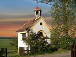
Budete-li mít
štestí na pocasí, naskytne se Vám v místech, kde je kaplicka
Sv.Václava, nevšední pohled na Novohradské hory, zleva Vysoká
(GCPZWG), Kraví hora (GC102R0) a Kuní hora (GCK6JG). Budete-li mít
ješte vetší štestí na pocasí, zahlédnete na horizontu lesa pod
Kraví horou barokní farní kostel Nanebevzetí Panny Marie v Dobré
vode (GCYJ8X). Budete-li mít nejvetší štestí a budete tu ve
12hod, uslyšíte vyzvánení zvonu z borské kaplicky. Na míste
souradnice zjistete císlo popisné domu U Dušku = A.
STAGE 2 „U
Vodníka“
Vydejte se na
souradnice N 48° 53.105 E 014° 48.595. Tady obvykle a (skoro)
celorocne sedí na molu rybnícka borský vodník. Krome zimy, to
odjíždí do Pieštan J
. Zjistete císlo
popisné domu priléhajícího k rybnícku =
B.
STAGE 3
„Finálka“
Cache
naleznete na souradnicích N48 52.X , E014 49.Y
X = (54 x A)
+ 11
Y = (9 x B) +
46
Pro kontrolu
správnosti souradnic:
Ciferný
soucet císlic tvorících X = 2, ciferný soucet císlic tvorících Y =
1
(EN)
BOR
(GC1HQRG)
Bor
can be found close to the road from „Suchdol nad Luznici“ to
„Salmanovice“. Bor was founded in 1560 by Vilem from Rozmberk under
the name of „Lhota Vilemova.“ As a new village it has been also
called „Nova Ves za Suchdolem“ and also „Nova Ves na Boru“. At the
end only the name „Bor“ remained. Even though it has been a
small village, hidden by deep forests, the suffering related to so
called 30-years war did not get out of it. The village has been
completely desolated and become depopulated. Authorities have
succeeded with the new settlement long time after. The renewed
village has been a part of Salmanovice till 1891. In the year 1920
thee has been a population of 14 residents, after the
land-transformation act the number of farmers increased to 40. On
the south side of Bor large peat-bog ( 465 ha ) can be found, where
till the beginning of 60th years of 20th century residents got the
peat – vital necessity how to get a fuel for their homes. This area
continuously passes to protected peat-bog „Cervene blato“ (see
GCVYB9).
This multi-cache will
guide you through Bor, showing you some unrepeatable views to the
region, especially „Novohradske hory“ Mountains.
You
can park your car at the coordinates N48 53.008 E14 49.046, which
is the initial stage.
STAGE 1 „U Dušku“
pub
Go
to the coordinates N48 53.062 E14 48.803.
If
you are lucky and the weather is nice, you will see close to the
St. Venceslav Chapel extraordinary view to „Novohradske hory“
Mountains. From left to right these are „Vysoká“ Mount (see
GCPZWG), „Kraví hora“ Mount (see GC102R0) a „Kuní hora“ Mount (see
GCK6JG). If you are even more lucky you can see on the horizon,
just beneath the „Kraví hora“ Mount baroque parish church of
„Nanebevzetí Panny Marie“ in „Dobra Voda“ (see GCYJ8X).
And, if you are even more lucky and you are here her at the
noon, you can hear the bell from the St. Venceslav Chapel. At the
coordinates find out the land-registry number of the house. Cannot
see it? You can surely handle it even w/o seeing the number. This
is the number „A“.
STAGE 2 „By
Water-man“
Go
to the coordinates N 48° 53.105 E 014° 48.595 . Here you can
usually see (almost) all year round the small water-man sitting at
the bank of the small pond. Except of winter, when he travels to
Piestany Spa J
. Find
out the land-registry number of the house. This is the number
„B“.
STAGE 3
„Final“
Cache can be found at the
coordinates N48 52.X , E014 49.Y, where
X =
(54 x A) + 11
Y =
(9 x B) + 46
Check can be done as the
sum of the digits of X and Y, which should be X = 2 and Y =
1