Mojave Desert EarthCache
-
Difficulty:
-

-
Terrain:
-
Size:  (other)
Related Web Page
Please note Use of geocaching.com services is subject to the terms and conditions
in our disclaimer.
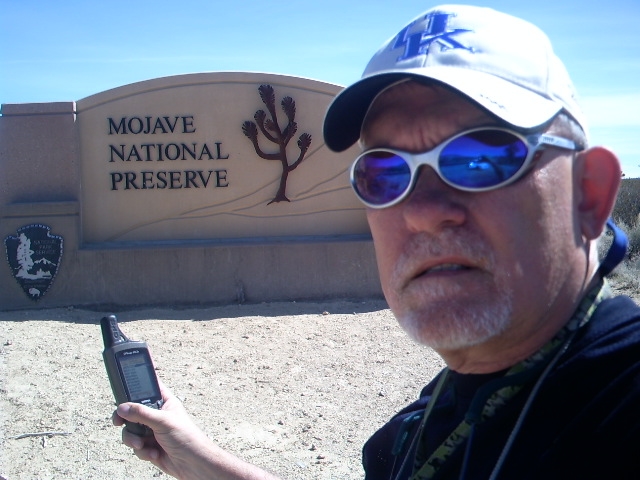
The Mojave Desert
Please leave a FAVORITE POINT for this historic little town!
 Westward from Nipton
______________________________________
What is a desert? A desert is a landscape or region that receives an extremely low amount of precipitation, less than enough to support growth of most plants. Deserts are defined as areas with an average annual precipitation of less than 10 inches per year, or as areas where more water is lost by evapo-transpiration than falls as precipitation.
Mojave Geology The oldest rocks exposed in the Mojave National Preserve are between 1.7 and 2.5 billion years old (early Proterozoic age). They consist of metamorphic rocks derived from pre-existing sedimentary, volcanic, and igneous intrusive rocks. Some of these rocks contain high-grade metamorphic minerals and textures consistent with having experienced pressures and temperatures typical of the lower crust between 12 and 25 miles below the Earth's surface.
After about 1.4 billion years ago, the region that is now the Desert Southwest experienced little structural change, and erosion gradually wore down the landscape to a nearly level plain A large "supercontinent" that had assembled earlier in time began to break apart, and a proto-Pacific basin began to develop. The edge of the North America continent gradually sank beneath the ocean surface, and a thick sequence of sedimentary rocks began to accumulate on the continental margin (see "A" in figure below). The oldest of these sedimentary deposits are over a billion years in age. These deposits formed from sand, mud, and limey sediments deposited in shallow marine conditions, similar to the modern continental shelf around the Gulf of Mexico. This passive continental margin setting persisted for nearly 800 million years, starting in the late Proterozoic and lasting through all of Paleozoic time (570 to 245 million years ago). The great carbonate-rich (limestone and dolomite) sedimentary rock section (as much as 10 kilometers thick) preserved in the Mojave region is a testament that during this vast period of time, North America had gradually drifted northward across the equatorial region, home to warm, shallow, continental platform seas teaming with shelly organisms (mostly algae and invertebrates). These carbonate rock formations today are home to many fossils

The thick sequence of late Proterozoic and Paleozoic sedimentary formations was folded and broken up by faulting that began with the formation of the Cordilleran range along the western margin of North America. Beginning around 250 million years ago, the great ancient supercontinent of Pangaea began to rift apart, forming the Atlantic Ocean basin. The North American continent gradually split away from what is now northern Africa and Europe. This relative-westward motion of the North American continent caused the western margin of the continent to change from being a passive to an active continental margin. The western margin of the continent began to override the adjacent oceanic crust beneath the Pacific Ocean (see "B" in figure above). Along with subduction of oceanic crustal uplift of the continental margin began, and erosion began to strip away the exposed rocks and sediments. Magma generated by subduction processes began to intrude upward, some of which reached the surface and erupted to form volcanoes. Beginning in the Jurassic Period, an extensive volcanic arc developed across the greater Mojave region. Deep below the surface, a series of great igneous intrusions (called batholiths) gradually became emplaced throughout the region. These igneous rocks (consisting mostly of granite) form the cores of the Sierra Nevada and many of the ranges throughout the Mojave region, including virtually every mountain range in the Mojave National Preserve. Great granitic intrusions formed in the Jurassic (170 to 140 million years ago) and again in mid-Cretaceous time (about 100 million years ago).
Intrusion and volcanism ended in the region in Late Cretaceous time and erosion was the dominant process throughout the early part of the following Tertiary Period. Beginning around 30 million years ago (during late Oligocene time) new tectonic forces began to modify the landscape (see "C" in figure above). A great rift-style fault system developed across the region as the Great Basin began to spread apart. The history of late Tertiary and Quaternary faulting and tectonism in the Mojave National Preserve is unlike any other geologic province in California. The tectonic framework for much of the Preserve is perhaps most similar to the Basin and Range-style structure of Arizona, but in contrast there are no deep basinal deposits and no big normal faults. Two detachment fault systems affected parts of the Preserve around 18 million and 14 million years ago. The Ivanpah Valley formed after 10 million years, probably as extensional bend in a strike-slip fault. Faulting is modifying the regional landscape, however, rather that basin-and-range-style faulting, fault systems active in the region today are associated with regional right-lateral shearing forces associated with the San Andreas Fault System, the Garlock Fault, and the Eastern California Shear Zone.
Throughout the Late Tertiary and Quaternary periods, large volcanic eruptions occurred fairly frequently in the Great Basin region. Volcanic ash blanketed the landscape, and many of these ash beds are preserved in the alluvial deposits that accumulated in the basins. Eruptions associated with the Cinder Cones and Lava Beds area within the Mojave National Preserve began in the Late Tertiary (around 7 million years ago) and has continued episodically through late Quaternary time (in the past one million years). The last volcanic episode in this area occurred only about 8,000 years ago.
Climatic changes during the last million years are largely responsible for most landscape features in the Mojave region today. In many ways, the character of modern alluvial fans, pediment surfaces, and playas, and the flora and fauna they support, reflect conditions that have evolved mostly within the past several thousand years. However, in addition to climate, the physical characteristics of these modern landscape features are tied to the properties of bedrock materials and tectonic history of any particular location.
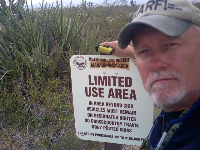
The Mojave Desert covers over 22,000 square miles and stretches across parts of four States. The desert's boundaries are generally defined by the presence of Joshua trees considered an indicator species for this desert.
The desert elevation is generally between 3,000 and 6,000 feet above sea level. But some places are much higher or lower. For example, the elevation at Charleston Peak is 11,918 feet above sea level and Badwater in Death Valley is 282 feet below sea level.
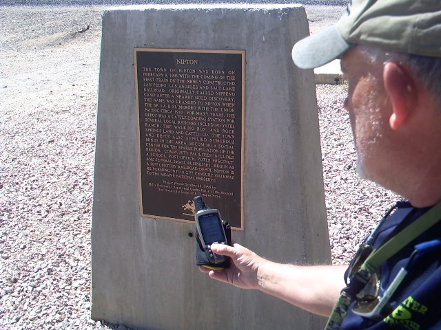

Nipton and The Mojave Desert
________________________________________
The coordinates will take you to the roadside marker in the image above (left). It's located in the tiny remote desert community of Nipton, California situated just outside the northernmost boundary of the Mojave Desert Preserve. If you like the desolate charm of towns on the backside of nowhere, Nipton is for you.
To Log This Earthcache. Demonstrate the educational value of your visit by emailing answers to the following questions to the link below:
1. Deserts are defined as areas with?
2. Intrusion and volcanism ended in the region during what period?
3. What are the highest and lowest elevations of the Mojave?
4. The desert's boundaries are generally defined by what?
5. What name is on the iron skillet art pictured above (center)?
Please email answers to:
-=ARF!=-
Please don't forget to leave a FAVORITE POINT for this historic little site!
Do not wait on a reply from me. Simply send the answers in an email to me and log the Earthcache. FOUND IT logs which do not meet requirements will be quietly removed.
Additional Hints
(Decrypt)
Ernq grkg, znexref. Gur veba neg vf va sebag bs gur uvfgbevp ohvyqvat arneol.