Bucknall Erratic EarthCache
-
Difficulty:
-

-
Terrain:
-
Size:  (not chosen)
Please note Use of geocaching.com services is subject to the terms and conditions
in our disclaimer.
A large boulder in a Park on a housing Estate in Stoke on Trent, brought here by a Glacier
This area of the UK isn't known as "The Potteries" by accident – unless you count the geology of an area being due to an accident. This area contains large deposits of clay and also coal,which are essential for the brick-making and pottery industries that grew up in the area, as shown in the sketch map. 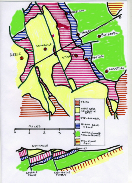
The sandstones and mudstones found across much of the area were deposited under dry, desert-like conditions around 210-250 million years ago. Encroaching coastal lagoons and mudflats covered over the sands and gravels through time leaving the mix of sandstones and mudstones.
The clay (Etruria Marl is the most prolific) has been dug out since the 15th Century, initially for making pottery. There are other clays in different seams with different colours from red, dark yellow to white. The white was used for clay pipes. When a particular area became difficult for removal of any further clay it was abandoned and the retrieval of clay moved on to the next suitable access point. The holes that were abandoned were known as "Marl Holes". In the seventeenth century potters dug clay out of the local roads as cultivated land was too valuable. Eventually the roads were so dangerous that the offenders were forbidden by law to continue the practice. It is thought that this is where the term "Pothole" comes from. These days the clay is obtained through open cast mining.
The coal measures cover a depth of around 3,500 feet with around 25 separate seams of coal running through them. They were formed between 360 and 285 million years ago. The top layer of coal measures is of the Black Band Group. These include two of the greatest importance types of coal for local industry - these are ‘long flame coals’ - essential for firing pottery ovens. Some of the famous seams carry names like - Great Row, Hard Mine, Bowling Alley, Cox’s Head, and Mossfield. Because the coal seam emerged at the surface in some areas it could be picked up from the ground without even digging for it. In other areas it was dug out until the seam was followed underground in sloping tunnels called ‘footrails’ or ‘adits’. Coal was being dug in the Stoke-on-Trent and North Staffordshire area as early as 1282, and by 1467 the Great Row coal seam was being mined and used for firing pottery.
During the last ice age, which started about 20,000 years ago the power of the glaciers was such that, besides carving out valleys, they could pick up boulders that had been broken away from large rocky outcrops and carry them for tens and sometimes hundreds of miles. These boulders are called erratics and they vary in size from a few kilogrammes to several hundred kilogrammes.
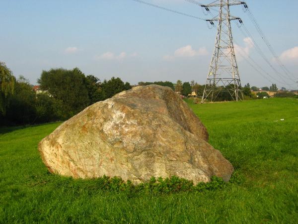
The location is a bit unusual in that it is in a small park in the middle of a housing estate. It has been rolled a few metres from it's original position to make room for a new medical centre. However, it's not the only one locally, just the largest. There are others at the local B&Q DIY warehouse, the Staffordshire University, Keele University and one in a park in Tunstall, another suburb of Stoke on Trent.
Please be careful when you visit.....we've been warned that the local dog owners seem to be using the vicinity as a dog loo..
The above co-ordinates are for the erratic.
Car parking is available a short distance away in Twigg Street at N52 01165 W002 08.399
In order to claim this earthcache you'll need to submit the following...
A photo of you and/or your GPS device, at the boulder, uploaded to the visit log if you wish to. Answers to the questions detailed below - these are a must. You don't need to wait for a reply and may not even get one if we are too busy but we will contact visitors without answers being sent and the logs will be deleted if they are not complied with.
Email us with the answers to the following questions...
1 - Approximately how many years ago did the last Ice Age end? You'll need to go onto the web to find the answer.
2 - What is the circumference of the boulder about 30 cm above the ground.
Don't forget to take a tape measure with you
Firtst to find honours go jointly to "ivanidea" and "bridgeplayer2"
Additional Hints
(No hints available.)