Gletscherschliff St. Koloman EarthCache
Gletscherschliff St. Koloman
-
Difficulty:
-

-
Terrain:
-

Size:  (not chosen)
Please note Use of geocaching.com services is subject to the terms and conditions
in our disclaimer.
 This
earthcache has a parking area (N47°39.473'
E013°10.409').
This
earthcache has a parking area (N47°39.473'
E013°10.409').
Gletscherschliff St. Koloman
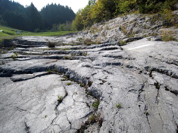
Deutsch Der „Gletscherschliff“ in St.
Koloman wurde1974 im Zuge des Ausbaus der St. Kolomaner
Landesstraße freigelegt. Er liegt etwa 2 km außerhalb des
Ortskernes und die freigelegte Fläche wurde 1975 zum Naturdenkmal
erklärt und der Öffentlichkeit zugänglich gemacht. Der in der
letzten Eiszeit (Würmzeit) vor ca. 50.000 bis 10.000 Jahren
entstandene Gletscherschliff hat eine Gesamtfläche von ca. 1500 m²
und besteht aus einer ca. fünf Meter hohen Böschung aus
„Barmsteinkalk“ sowie einer Sohle aus „Oberalmer Mergelkalk“. Er
ist das größte derartige Gebilde in dieser Seehöhe Salzburgs. Auf
vier Informationstafeln wird die Entstehung dieses Gletscherschiffs
ausführlich erklärt.
Deine Aufgabe: Mache ein Foto von Dir (mit GPS) und dem
Gletscherchliff.
Stelle dieses Bild in Deinen Log.
Beantworte folgende Fragen uns schicke mir die Antworten per email.
Sind diese korrekt, erhälst du die Logerlaubnis.
a) Welches Thema hat die Tafel 1?
b) Welche Höhe erreichte der Salzachgletscher im Bereich St.
Koloman?
English Glacial Polish St. Koloman
The „Glacial Polish“ in St. Koloman was discoverd and ecavatet in
the course of the expansion of the St. Kolomaner road in 1974. It
is locatet 2 km beyond the village and the dissectet area was
declared as a naturalmonument in 1975 and opened to the public.
This “glacial Polish” emerged in the last icege 50.000 to 10.000
years ago and has a total area of 1500m². It consists of a five
meters high slope of “Barmstein -lime” and a bed of marly
“Oberalmer-lime”. It is the biggest such formation in this sea
level of Salzburg. At four boards you can find detailed information
over the development from the “Glacial Polish”.
Your Task: Take a picture of yourself (with GPS) and the “Glacial
Polish”. Place the picture in your log.
Answer following questions and send me an email. If the are
correct, you get a permision to log.
a) What is the main theme of board 1?
b) What height achieved the Salzachglacier in the area of St.
Koloman?
Logs ohne Logerlaubnis und ohne Fotos werden vom
Owner komentarlos gelöscht!!
Logs without permission and picture will be deleted!!

Besucher
Additional Hints
(No hints available.)