Historischer Bergbau im Ardeygebirge EarthCache
Historischer Bergbau im Ardeygebirge
-
Difficulty:
-

-
Terrain:
-

Size:  (not chosen)
Please note Use of geocaching.com services is subject to the terms and conditions
in our disclaimer.

Historischer Bergbau im Ardeygebirge
Historical mining at the Ardeygebirge
Das Ardeygebirge ist ein bewaldeter Höhenzug im Süden von Dortmund. Südlich und westlich wird es von der Ruhr umfaßt. Im Norden geht es im Stadtgebiet von Dortmund allmählich in das Tiefland des Münsterlandes über. Im Osten setzt sich das Ardeygebirge nahtlos im Haarstrang fort. Entlang der Ruhr zeigt das Ardeygebirge einen ausgesprochen gebirgigen Charakter. Große Höhenunterschiede, felsige Steilhänge und tiefe Kerbtäler prägen hier das Landschaftsbild.
The Ardeygebirge is a wooded mountain trail in the south of Dortmund. South and west it is covered by the Ruhr. Into the north it changes in the city from Dortmund gradually into the low country of the Muenster. In the east of the Ardeygebirge continues smoothly in shedding rank. Along the Ruhr the Ardeygebirge shows one expressed a mountain character. Large differences in height, rocky steep rock slopes and deep identation valleys coin/shape here the landscape.
In Dortmund-Syburg stehen in der südlichen Syburger Mulde die ältesten Schichten des produktiven Oberkarbons an.
Man kann das Oberkarbon, auch als das Zeitalter der Farne bezeichnen. In weitausgedehnten Kohlesümpfen entstanden die weltgrößten Vorräte an Steinkohlen. Die beherrschenden Vertreter der Flora in den Kohlesümpfen waren die Gattungen Lepidodendron (Schuppenbäume) und Sigillaria (Siegelbäume), baumartige Pflanzen, die zur Pflanzenabteilung der Bärlapppflanzen (Lycopodiopsida) gezählt werden. Die Vertreter beider Gattungen erreichten Größen von bis zu 40 Metern und Stammdurchmesser von über einem Meter.
In Dortmund Syburg the oldest layers of the productive upper carbon line up to the southern Syburger hollow. One can call the upper carbon, also the age of the ferns. In by far-lengthened coal sumps the world largest supplies of hard coals developed. The controlling representatives of the Flora in the coal sumps were the kinds Lepidodendron (shed trees) and Sigillaria (seal trees), tree-like plants, which are ranked among the plant department of the Bärlapppflanzen (Lycopodiopsida). The representatives of both kinds reached sizes of up to 40 meters and master diameters of over one meter.
Direkt nördlich an der Ruhr speziell am nordwesthang des Sybergs in Dortmund wurde aus einem der geologisch ältesten, abbaubaren Steinkohlenflöze im Ruhrgebiet die ersten Kohlen gefördert. Es handelt sich hierbei um das Flöz Sengsbank was erstmals 1582 urkundlich erwähnt wird. Im laufe der Zeit entstanden hier weitere Abbaustellen wie z.B. die Stollenzeche Beckersches Feld (16. Jahrhundert) oder die Stollenzeche Schleifmühle (18. Jahrhundert) sowie Graf Wittekind (19. Jahrhundert)
Directly north at the Ruhr particularly at the northwest slope of the Sybergs in Dortmund from one of the geologically oldest, degradable hard coal in the Ruhr district the first coals one promoted. It concerns here the seam Sengsbank which 1582 documentary is for the first time mentioned. In run the time developed here further dismantling places like e.g. the lug bill Becker field (16. Century) or the lug bill sharpening mill (18. Century) as well as count Wittekind (19. Century)
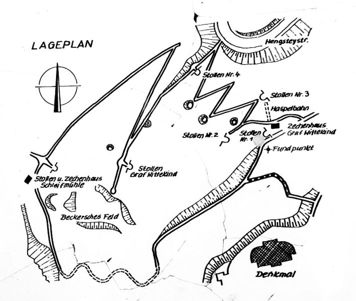
Der Syburger Bergbauweg verbindet die Stollen und Einsturztrichter dieser drei Bergwerke und hat eine Länge von etwa 2km. Zu sehen sind vier renovierte Stollenmundlöcher, ein Flözaufschluss, die Standorte ehemaliger Zechenhäuser und einer Handwinde, ein Bremsberg sowie frühe Kohlenziehwege. Darüber hinaus eröffnet der beschilderte Wanderweg, der zwar nur 2,5 km lang ist, aber durch steiles Gelände führt, auf kleinem Raum einen Einblick in die Bergbaugeschichte des Ruhrgebietes. Seit 1997 sind die Stollenzechen ein von der Bergbehörde anerkanntes und überwachtes Besucherbergwerk.
The Syburger mining way connects the lugs of these three mines and has a length of 2km. To see four reconditioned lug mouth holes, a seam explanation, are the locations of former bill houses and a hand winch, a brake mountain as well as early coal drawing ways. Beyond that opens the walking way, which is only 2.5 km long, but by steep area leads, on small area a view of the mining industry history of the Ruhr district. Since 1997 the lug bills are a visitor mine supervised recognized by the mountain authority.
Um diesen Cache zu loggen, mache bitte:
Ein Foto von Dir oder deinem GPS vor dem Stollen der Zeche Graf Wittekind bei N 51° 25.279 E 007° 28.858 (optional, aber nett) und beantworte mir folgende Fragen per Mail:
Das Karbon wird international in zwei Serien unterteilt nenne sie mir.
Vier Mann erbrachten 1873 die höchste Jahresförsdermenge wie hoch war sie?
An der Infotafel ist die Rede von Flöz Sengsbank wie mächtig war es?
In order to log this cache, make please:
A photo of you or your GPS before the lug of the bill count Wittekind at N 51° 25,279 E 007° 28,858 (optional) and answers the following questions by mail:
The carbon is internationally divided into two series call me them.
Four men furnished 1873 the highest delivery how much was it?
At the infoboard is the speech of seam Sengsbank how powerfully was it?
Additional Hints
(No hints available.)