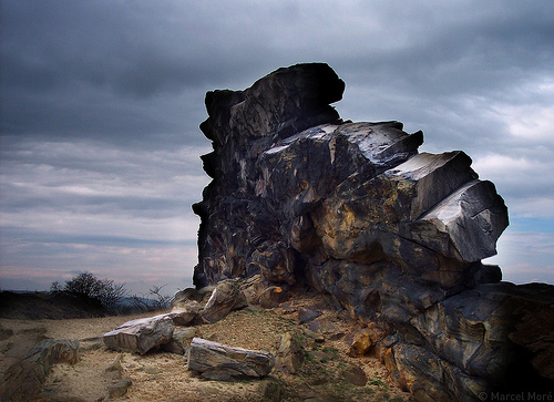
Als in der Kreidezeit die Harzschollen empor gepresst wurden, kam es auch zur Herausbildung des kleinen und stellenweise unterbrochenen Höhenzuges, der am Regenstein bei Blankenburg beginnt und sich über acht Kilometer hin bis zu den Gegensteinen bei Ballenstedt zieht. Der schönste Teil (ca. 135,37 ha) liegt in der Gemarkung Weddersleben und wird "Teufelsmauer" genannt. Schon im Jahre 1784 besuchte Goethe die sagenumwobene Sandsteinwand und fand sie "So merkwürdig schön". Am Anfang des 19.Jahrhunderts wurde der Abbau des Sandsteines der Teufelsmauer immer lukrativer. Der weiche Sandstein hatte eine gute Qualität, und der harte Sandstein eignete sich sehr gut als Mauer- und Pflasterstein. So nahmen die Betriebe, die sich mit dem Abbau und der Verarbeitung beschäftigten, rapide zu, so dass man von behördlicher Seite diesen Prozess stoppen musste, um der Nachwelt diese sehenswerte Gesteinsformation zu erhalten. Das Gebiet der Teufelsmauer wurde am 08. Juli 1852 durch den Landrat Weyhe von Quedlinburg als ein „Gegenstand der Volkssage und eine als seltene Naturmerkwürdigkeit berühmte Felsgruppe“ unter Schutz gestellt, in dem er jeglichen weiteren Abbau des Sandsteines verbot. Dieses Schutzgebiet wurde dann einige Jahre später auf das heutige Maß erweitert. 1935 wies eine Verordnung des Regierungspräsidenten in Magdeburg sie als ein Naturschutzgebiet aus, das älteste Naturschutzgebiet Deutschlands. Die Teufelsmauer kann bequem umwandert werden und bietet von einer angelegten Plattform auf dem Höhenzug einen fantastischen Blick zum Harz und ins Harzvorland. Wer mit der Bahn von Quedlinburg in Richtung Thale fährt, sieht das mächtige Gebilde der Teufelsmauer aus Sandsteinquader, welches sich in Königsstein, Mittelsteine und Papensteine unterteilt, rechtsseitig der Bahn.

Die Sage der Teufelsmauer
Vor Urgezeiten, als Gott und Teufel die Erde unter sich aufteilten, wurde zwischen beiden vereinbart, daß dem Teufel all das Land gehören sollte, welches er in einer Nacht bis zum ersten Hahnenschrei mit einer Mauer umbauen konnte.
In jener Nacht, als der Teufel sein Bauwerk begann, war nun aber eine alte Frau unterwegs, die auf dem Markt einen Hahn verkaufen wollte. In der Dunkelheit stolperte sie, und der Hahn erschrak sich dabei und begann zu krähen. Der Teufel hörte dies und dachte, daß seine Zeit schon um sei und riß vor lauter Wut die Teufelsmauer wieder ein. Die Reste sind bis auf den heutigen Tag stehengeblieben.

Die Teufelsmauer im nördlichen Harzvorland zieht sich eine eigentümliche Felsformation von Blankenburg nach Weddersleben nach Rieder und nach Ballenstedt.
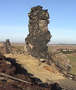
Dieses Mini-Gebirge ist die Teufelsmauer, eines der ältesten Naturschutzgebiete Deutschlands. Wie an einer Schnur aufgefädelte Felsen lenken die Blicke auf sich in einer ansonsten schon relativ ebenen Umgebung. Den höchsten Punkt bildet der "Großvater" (Felsen bei Blankenburg) und bei Neinstedt gibt es eine hölzerne Aussichtsplattform auf der Teufelsmauer.

1) Wie heißen mindestens 2 der Felsen neben dem "Großvater" ?
2) Aus welchen Steinen bestehen die Felsklippen der Teufelsmauer ?
3) Welche Flora kommt auf den Sandböden der Teufelsmauer vor ?
4) Auf Grund der massenweisen Weitergabe von EC-Lösungen im Internet stellen GSA und Groundspeak es den EC-Besitzern seit dem 10. Juni 2019 wieder frei, ein Foto als Beweis des Besuches zu fordern. Ein Foto von sich selbst oder eines persönlichen Gegenstandes vor dem Hintergrund der EC Location ist nun PFLICHT. Falls das Foto nach einer Erinnerung immer noch nicht hochgeladen wird behalte ich mir die Löschung des Logeintrages vor.
Schicke die drei Antworten per email an mich und logge den Cache. Wenn etwas falsch ist, melde ich mich bei Euch.

As the 1.Harz clods were being pushed upwards during the Cretaceous period, there was also the formation of a small and in parts broken mountain range, that starts near Blankenburg and stretches over eight kilometres up to the Gegensteinen near Ballenstedt. The nicest part (approx. 135,37 ha) lie in the bounds of Weddersleben and is called "Devil´s Wall". As far back as 1784 Goethe visited the legendary sandstone wall and found it “So curiously beautiful”. At the start of the 19th century the quarrying of the “Devil's Wall” sandstone became ever more lucrative. The soft sandstone had a good quality and the hard standstone proved itself as being very good as a wall and paving stone. So the number of companies that were involved with quarrying and processing increased rapidly, so that this process had to be stopped by the authorities in order to preserve this rock formation for posterity. On the 8th of July 1852 the area of “Devil's Wall” was put under protection as an “Object of folk legend and as a famous rare, curious natural group of rocks” by the head of the administration Mr. Wehye von Quedlinburg, in which he prohibited any further quarrying of the sand stone. This protectorate was then extended several years later to its present size. In 1935 an decree issued by the chairman of the regional council in Magdeburg declares it as a nature reserve, the oldest nature reserve in Germany. The “Devil's Wall” is easily walked around and from a platform positioned on the hill range it offers a fantastic view of the Harz and the Harz foothills. If you travel by train from Quedlinburg in the direction of Thale, you can see to the right of the tracks, the massive creation of the “Devil's Wall” made up of square sandstone blocks, which are subdivided into the Königstein, Mittelstein and Papenstein.
The “Devil's Wall” legend
In primeval times, as God and the Devil were dividing the Earth between themselves, they both agreed that all the land that the Devil could enclose with a wall, during one night until cockcrow, would belong to him.
In the night that the devil was beginning his construction there was however, an old lady on her way to the market to sell a rooster. In the darkness she stumbled and the rooster got startled and started to crow. The Devil heard this and thought that his time was up and in his anger he pulled the “Devil's Wall” down again. The remainders of which have stayed up unto this day.
In the northern foothillls of the Harz there is a strange rock formation that stretches from Blankenburg to Weddersleben to Rieder and to Ballenstedt.
This mini-mountain range is the “Devil's Wall” one of Germany´s oldest nature reserves. The rocks as though threaded on a string, draw the attention upon themselves in an otherwise relatively flat surrounding. The highest point is formed by the “Grandfather” (rocks near Blankenburg) and near Neinstedt there is a wooden observation platform on the “Devil's Wall”.

1) Name at least two of the rocks next to the "Großvater" ?
2) Of what stones are the rock cliffs of the "Devil's Wall" made up of ?
3) What flora is found in the sandy soil of the "Devil's Wall" ?
4) Photo
Please send the answers to my email.