É triste ver logs sem foto
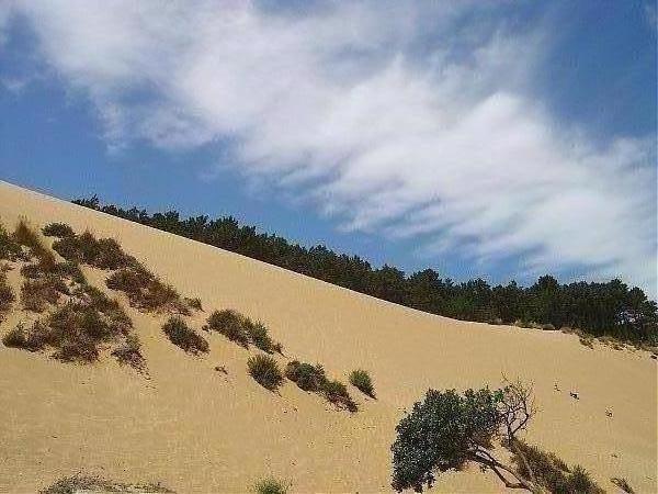
Duna de Salir
N:39º 30,099
W:009º 09,071
A duna ter-se-á formado à custa de materiais provenientes da praia e do rio de Tornada, transportados pelos ventos, tendo-se depositado junto à arriba, pois esta serve de obstáculo à passagem dos ventos.
Actualmente esta rampa de areia está sujeita a um processo de erosão, não só pelo escavamento da base devido à ondulação e ao rio de Tornada, provocando pequenos desmoronamentos, responsáveis pelo forte declive que apresenta, como ainda pelo intenso pisoteio a que está sujeita. Erosão esta que não é compensada pela quantidade de areias que ali chegam transportadas pelo vento.
A erosão da duna pôs a descoberto areias vermelhas, mais compactadas e mais antigas. Encontram-se também fragmentos de areia com consolidação, cujos grãos estão unidos por carbonatos e apresentam um esboço de estratificação, que são o vestígio de uma duna mais antiga, denominada “duna fóssil”.
A área coberta com vegetação dunar.
Esta vegetação, pelas suas características, nomeadamente pela extensa rede de raízes que apresenta, permite a fixação das areias, evitando a erosão das dunas e contribuindo para a sua estabilização.
Para fazer o log quero:
-Uma fotografia vossa com o GPS, junto as tábuas de sustentação da duna.
-Saber quantas tábuas de sustentação da duna existem.
-E qual a altura média da duna.
Respostas por mail não no log. (Através do meu perfil).
A foto deve ser colocada no log após confirmação de que as respostas estão correctas. Log sem foto ou log sem autorização será apagado.
-
Duna of Salir
N:39º 30,099
W:009º 09,071
The dune will be formed at the cost of materials from the beach and the river of Tornada, carried by winds and it was deposited with the cliff, because it serves as a barrier to passage of the winds.
Currently the ramp of sand is subject to a process of erosion, not only by dig the base due to the ripple of the river and Tornada, causing minor landslides, responsible for the sharp slope that presents, but also by intense trampling on which it is subject. Erosion this is not compensated by the amount of sand who arrive carried by the wind.
The erosion of the sand dune has discovered the red, more compressed and older. There are also fragments of sand with consolidation, whose grains are united by carbonates and present an outline of stratification, which is the vestige of an older dune, known as "dune fossil."
The area covered with vegetation dunes.
This vegetation, their characteristics, including the extensive network of roots which, allows the setting of sand, avoiding the erosion of dunes and contributing to its stability, stresses. To make the log I want to:
- A photo with your GPS, with the support of the boards of dune.
- How many boards to support the dune there.
- What is the height of the dune.
Responses by mail not in the log.(Using my profile to send).
The photo should be placed on the log after confirmation that the answers are correct. Log without photo or log without authorization will be erased.

h_raky Geocaching Tour Guides 
