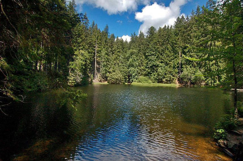
Boubin lake / Boubínské jezírko
ENG.:
Primary
data
Wood complex in the ascendent Boubina and federation
partition, 2 – 6 kilometers northing from village
Zaton.
Catastral territory:
Vcelna below Boubinem, Upper Vltavice (district
Prachatice)
extent: 677,33
ha
elevation above
sea-level: 874 – 1362,2 m
Founded: 1933
(servant decision proprietor in r. 1858)
Describe
of region
The virgin forest of Boubin is situated on
the southeastern slope of Mt. Boubin (1362 m) that used to be a
part of a property of the family of Schwarzenberg. Joseph John
founded it in 1856 and it consisted of 47 ha. The area was changed
several times, finally it is 666 ha, and 47 ha are surrounded with
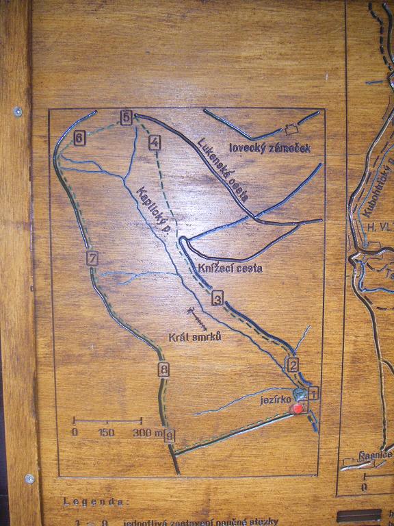
a fence that should protect the plants from animals. An instructive
path in length of 5 km follows it. On your trip through a mixed
forest you can learn many interesting things about the history of
the forest from 9 informative panels. You can see really giant
trees - "the King of spruces", is 460 years old, 57.5 m high and
its volume is 30 m3 . It is a pity that you cannot see
it any more from the path. The starting point is the Boubin lake
that was used to transport wood to the glass factories in Lenora.
On the way back to the parking you will pass the Ida's sawmill, now
a tourist information centre during the summer season.
Much of the original 138 hectares of forest was destroyed by a
windstorm in 1870. Ironically, the region has been damaged by
coring beetles, and the forest itself is out of bounds to
visitors.
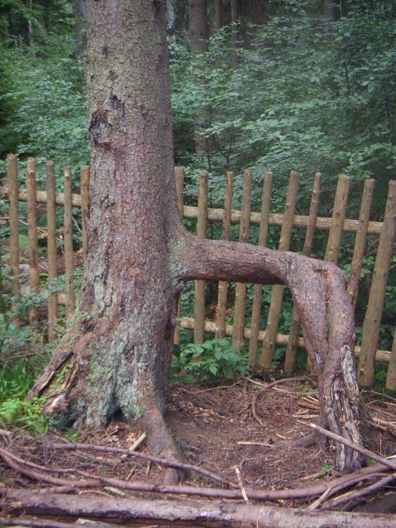
The type of the tree named "Chudový strom" /
Chudový strom
Geology
of region
Among steep slope natural
complex, which create Pažení (Basumsky back), summit Boubina
(1362,2 m n. m.) and flat back onwards slowly to Bobik, rise and
traverse Kaplicky creek. Stone base is creation pearl gneiss and
nebulosity and at the same time here trench paragneiss monotonous
set of moldanubikum. Deluvial and deluvial solifluxion clayey sand
and argillaceous stones deposits, in silt too fluvial clayey sand
and gravel forms stone base. In soil cover prevalence especially
podsole (largely on back) and crypt podsole
(brae).
Gneiss - rock stone
base
Gneiss is a common and widely distributed
type of rock formed by high-grade regional metamorphic processes
from preexisting formations that were originally either igneous or
sedimentary rocks. Gneissic rocks are usually medium to coarse
foliated and largely recrystallized but do not carry large
quantities of micas, chlorite or other platy minerals. Gneisses
that are metamorphosed igneous rocks or their equivalent are termed
granite gneisses, diorite gneisses, etc. However, depending on
their composition, they may also be called garnet gneiss, biotite
gneiss, albite gneiss, etc. Orthogneiss designates a gneiss derived
from an igneous rock, and paragneiss is one from a sedimentary
rock. Gneissose is used to describe rocks with properties similar
to gneiss.
Gneiss
resembles schist, except that the minerals are arranged into bands.
Sometimes it is difficult to tell the difference between gneiss and
a schist because some gneiss appears to have more mica than it
really does. This is especially true with mica-rich parting
planes
All answers are in
infoboard along path.
!!!Don´t
translate czech Describe!!!
Czech descripe do you
transcript only
For
the valid "cache found" log:
A) Send me via profile e-mail answers to next
questions:
1) Send me
name of the all infoboard (9 Pcs)
2) What animal
is in the picture in right bottom corner of infoboard 1? (hole row
uder picture)
3) Distance of
the "Chudový strom" (spoiler 2).
4) Year of the
fall the King of spruces. (start of the second row on the IB
3)
5) What animal
is in the picture in right bottom corner of infoboard 4
6) What is in
the picture in right bottom corner of infoboard 5?
7) Number of
the oldest tree describe in the IB6 (Spoiler 6).
8) How long is
"Plzák lesní" described in IB 7?
9) How many
percent of "dub lesní" form the forest.
B) Upload photo you with GPS from
TWO PLACES:
1) Photo at
Boubin lake
2) You must
find the type of the tree named "Chudový strom" and take photo with
this tree.
Incomplet logs wil be erased without advance
warning
CZ.:
Základní
údaje
Lesní komplex na vrcholu Boubína a svazích Pažení, 2
– 6 km severne od obce Záton.
Katastrální území: Vcelná pod Boubínem, Horní Vltavice (okres
Prachatice)
Výmera: 677,33 ha
Nadmorská výška: 874 – 1362,2 m
Vyhlášeno: 1933 (zrízeno rozhodnutím vlastníka v r.
1858)
Popis
oblasti
Rezervace Boubínský prales se nachází na
jihovýchodním svahu Boubína (1362 m) na pozemcích rodiny
Schwarzenbergu v roce 1856. rezervace byla založena
v roce 1856 na popud schwarzenbergského lesmistra Josefa Johna
který již v té dobe cítil že je treba zachovat unikátní
prírodní kout pro pozdejší generace. V roce 1858 prohlásil
Adolf Schwarzenberg cást boubínského masivu za prírodní rezervaci,
prales. Puvodní rozloha rezervace byla 150 ha. Nynejší
rozloha rezervace je 666 ha a jádro pralesa má rozlohu 47 ha a je
obehnán dreveným plotem zabranujícím vstupu zvere a turistu.
Soucasná drevinná skladba jádra rezervace je tvorena hlavne smrkem,
jedlí a bukem a odpovídá tak složením puvodním prirozeným
lesum na Šumave. Nekteré smrky a jedle zde dosahují stárí
300-400 let, výšek pres 50 m a prumeru 1,3m nad povrchem 150
cm. Nejvetší boubínský smrk 'Král smrku', byl starý 460 let,
výšku 57,5 m a objem témer 30 m3 drevní hmoty.
Velká cást pralesa o rozloze 138 ha byla znicena bourí v roce
1870. Následne byl polom napaden kurovcem.
The Journey thru forrest / Cesta
pralesem
Geologie
oblasti
Mezi strmými svahy prírodního komplexu, který tvorí Pažení
(Basumský hrbet), vrchol Boubína (1362,2 m n. m.) a plochý hrbet
pokracující zvolna k Bobíku, pramení a protéká Kaplický potok.
Skalní podklad je tvoren perlovými rulami a nebulity a soucasne sem
zasahují pararuly jednotvárné série moldanubika. Deluvální a
deluviálnesoliflukcní hlinitopíscité a hlinitokamenité sedimenty, v
náplavech také fluviální hlinité písky a štetopísky vytvárí
skalní podklad. V pudním pokryvu prevládá zejména podzol (hlavne na
hrbetech), podzol kambizemní a kryptopodzol (svahy). Ojedinele se
na skalnatých vrcholech vytvoril ranker kambizemní. .
Rula - hornina
skalního podkladu
Rula je hornina vzniklá za vysokého stupne
regionální metamorfózy z kterékoliv dríve vzniklé horniny, tj. at
už vyvrelých hornin nebo sedimentu. Ruly vzniklé z vyvrelin se
nazývají ortoruly, ruly vzniklé metamorfózou sedimentu jsou
pararuly. Je silne pravdepodobné, že rula tvorí velký podíl z
hlubší cásti kontinentální
kury.
Ruly se
vyznacují rovnobežnou stavbou (bridlicnatostí), která
muže mít ruzný vnejší vzhled, napr. zrnitá s nevýrazným
usmernením slíd, plástevná se souvislými slídovými pásky, okatá s
cockami svetlých nerostu, stébelnatá aj. Zrno mají ruly jemné
až hrubé. Jedna z nejhrubších rul je napr. rula
vyskytující se na Liberecku, tzv. ještedská rula. Barva je
svetle šedá, šedá, tmavošedá, žlutavá,
hnedá až cervenavá.
Podstatnou soucástí ruly je kremen, slída (muskovit, biotit) a
živec (ortoklas, plagioklasy). Pararuly jsou charakteristické
výskytem dalších nerostu, napr. grafitu, cordieritu, granátu
a silimanitu.
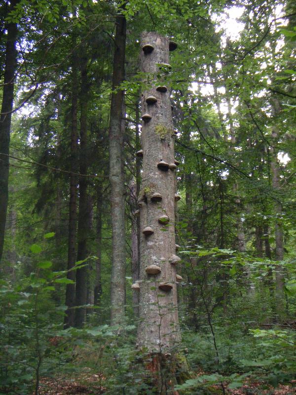
Deadly tree / Mrtvý strom
Pro
zalogování cache musíte splnit následující
podmínky:
PANELY BYLY ZMENENY, DOCASNE BUDU UZNÁVAT JEN
FOTO VIZ. NÍŽE.p>
B) Do logu
pridejte prosím vaše foto s GPS z následujících
míst:
1) Foto u Boubínského
jezírka
2) Behem cesty najdete
chudový strom a vyfotte se s ním.
!!!Nekompletní logy budou mazány bez predchozího
upozornení!!!