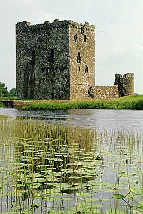
Threave Castle
Threave Castle stands on an island in the middle of the River
Dee. During the medieval period the water level was higher and the
island was only about a third of the size that it is today. Legend
tells that Threave Island was the home of the ancient rulers of
Galloway, but there is no physical proof of this. Archaeological
evidence does seem to suggest that there was an earlier castle on
the site, which by tradition was the residence of Fergus, Lord of
Galloway, and his descendants from the mid 11th century onwards,
and was probably destroyed by Robert the Bruce in 1308.
The current remains date back to the late 14th century when
Archibald 'The Grim', Third Earl of Douglas, built a castle on the
island. The fortress was centred on one of the earliest tower
houses to be built in Scotland. The Douglas family were the most
powerful family in Scotland and dominated Scottish politics. By the
mid 15th century the king, James II, was determined to break their
power by systematically destroying all the major Douglas
strongholds across the country. By June 1455, Threave was the last
castle still being defended in the name of the now exiled Earl of
Douglas. During a two month siege the king used the latest cannons
and bombards (giant siege guns) in an attempt to take the castle by
force, but its final surrender was more likely due to bribery than
the effectiveness of these weapons. The castle's ability to stand
up to such an attack was probably due to
the artillery fortification that was built around the tower house
shortly before 1455. The artillery wall had vertical slits through
which defenders could fire long-bows and cross-bows, and at three
of the corners was a round tower that was designed to accommodate
small guns. It was one of the first artillery defences to be built
in Britain.
Threave Castle then became a Crown property. A succession of
custodians was put in charge, and in 1513 the Maxwells were made
keepers, a position that became hereditary in 1526. The last
Maxwell keeper finally abandoned the castle in 1640 following a 13
week siege by an army of Covenanters. The castle was slighted and
partly dismantled, but was still substantial enough in the early
19th century to act as a prison for French troops captured during
the Napoleonic wars.
:: How to find the cache -
The listing co-ordinates are for the public car park (free) at
Kelton Mains. To find the final cache co-ordinates you will should
proceed to the location indicated by Waypoint P1. Here you will
find a blue marker with numbers printed upon it. Use this number to
decode the puzzle and identify the final cache co-ordinates.
There is a very good path, suitable for buggies or wheelchairs,
from the car park to GZ and you should follow it - otherwise you
might get your feet wet. CAUTION: Take extra care when the river
level is high.
You are looking for a 35mm film canister and stealth may be
required at times as this path can get busy. The view from ground
zero over distant hills provides a good excuse for hanging around -
happy hunting!
FTF: adambro - well done!
:: Facilities Nearby the cache -
We recommend a visit to Threave Gardens (Link)
where as well as beautiful gardens to explore, there is an
excellent restaurant and another walk with a cache - see Threave Estate Walk by HeadieD
Thanks to the Property Manager, Threave Estate, for allowing
the placement of this cache.