
From the guidelines, as from January 2013"People do not need to wait for permission to log your EarthCache. Requiring someone to wait is not supported by the EarthCache guidelines. People should send their logging task answers to you, then log your EarthCache. When you review their logging task answers, if there is a problem, you should contact them to resolve it. If there is no problem, then their log simply stands."

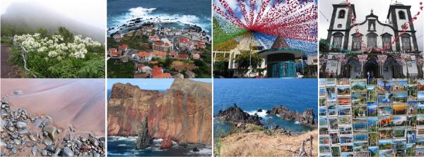
The Island of Madeira rises some 5000 m above the ocean floor and 1862 m a.m.s.l. Approximately 20 million years ago an underwater eruption deep in the Atlantic seafloor initiated the creation what is now known as the “Pearl of the Atlantic”. Both explosive (during which bombs and ash was violently expelled) and calmer effusive (where lava simply flowed downhill along the path of least resistance or simply filled in cracks) episodes of volcanism ensued. The cooling of these large volumes of lava formed basalt which is visible all over the island as a set of dykes and sills and in western Funchal as very thick, discrete sheets.
There is no volcanic activity on the Island of Madeira nowadays.
Madeira is located approximately 980 km SW of Lisbon, measures 58 km in an E-W direction and 23 km in a N-S direction and is a choice holiday destination.
Basalt is the most common igneous rock in the Earth's crust. Almost all oceanic crust is made of basalt and basalt is a common extrusion from many volcanic regions around the world. It forms from the melting of the upper mantle and its chemistry closely resembles the upper mantle's composition. It is generally silica-poor and iron- and magnesium-rich. Basalt originates from "hot spot" volcanoes, massive basalt flows and mid oceanic ridges.
Basalt also comes from extensive lava flows. Basalt lava flows are not very viscous (a measure of resistance to flow) and so can flow easily and quickly across great distances delivering great volumes of basaltic rock, eg. The Karoo in southern Africa.
Basalt makes up most of the oceanic crust and is formed at the plate boundaries as they are pulling apart. The melting of the mantle below the crust as it is spreading apart is called decompressional melting. It is the loss of pressure that causes the melting instead of an increase in temperature. The result is liquid basaltic magma rising and cooling on the edge of spreading tectonic plates forming prominent ridges. As the plates spread, more basalt attaches to the plate. Dating of oceanic rock shows that newer rock exists closer to the mid oceanic ridges as one would expect. Because basalt has magnetite as a typical component, when the basalt solidifies the magnetite crystals will be locked into place according to their orientation to the Earth's magnetic field. Since the Earth's magnetic field reverses itself from time to time, these magnetic reversals are recorded in the basaltic rocks.
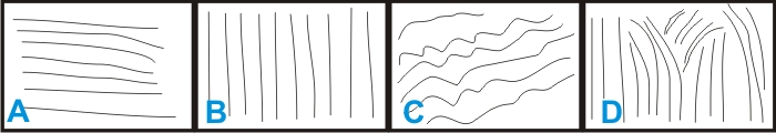
There are several types of basaltic rocks that are characterized by their features. Basalt that has a lot of volatile gases can have numerous vesicles or openings and is called scoria. Basaltic rock that cools slowly in a large thick layer will often form a distinctive hexagonal prismatic columnar jointing that produces "columnar basalt". Columnar basalt results from shrinkage during the solidification of the molten lava with the formation of hexagonal columns.
Basalt that forms from magma that extrudes into ocean water forms a type of basalt called "pillow lava" or "pillow basalt".
If basaltic magma does not solidify on the surface of the Earth, but cools in its interior it forms an intrusive igneous rock called gabbro.
The cache
The coordinates(*) will take you to western Funchal where if you face the cliffs and look up, you will see some spectacular columnar basalts. Choose from the images below which do you think represent the columns at this point: A, B, C or D? Are you up for this challenge? E-mail me the answers through my GC profile to validate your found.
(*) You do not need to stop at the exact coordinates to answer the questions. 50 m either side of the point along the walkway should be just fine.
NO tell-tale photos in the logs.
Have fun!

O basalto é uma rocha ígnea eruptiva, de grão fino, afanítica, isto é, os cristais não são vistos à vista desarmada, podendo, ainda, conter grandes quantidades ou ser constituído integralmente de vidro (material amorfo). Esta rocha é constituída principalmente de plagioclase e piroxena e, em muitos casos, de olivina. Como minerais acessórios encontram-se, principalmente, vários minerais, sendo os óxidos de ferro e titânio os mais freqüentes. A rocha basáltica geralmente possui cor escura acentuada (rocha máfica), sendo muito explorada para a costrução civil.
O basalto é produzido principalmente nas erupções que ocorrem: (a) nas cristas médio-oceânicas, que são o foco da expansão do assoalho oceânico e dão origem à chamada tectónica de placas, assim, a maior parte do fundo oceânico é constituído de basaltos; (b) em enormes derrames que formaram grandes plataformas continentais, como, por exemplo, da Bacia do Paraná ,no sul do Brasil, no norte da Sibéria, no planalto de Decan, na Índia e (c) em menor volume, embora mais evidentes, em erupções vulcânicas como em algumas das ilhas do arquipélago do Hawaii.
Em casos especiais o arrefecimento da lava causa contracção e desenvolve um sistema de fendas pentagonais, perpendiculares à superficie ao qual se dá o nome de "Disjunção Prismática do Basalto". Uma cache onde isto se pode observar é a do "Penedo do Lexim" do Lynx pardinus.
A cache:
Desta vez as coordenadas(*) levam-te para oeste do Funchal para um sítio chamado Ponta Gorda. Aqui, de costas para o conjunto de piscinas e olhando para cima diz-me, utilizando as imagens em baixo, qual o conjunto de imagens melhor ilustra a morfologia das colunas de basalto? A, B, C ou D? Conseguem superar este desafio?
Enviem-me uma mensagem com as devidas respostas para validar o vosso found.
(*) Não é necessário estar no ponto exacto das coordenadas para responder à pergunta. 50 m para cada lado do ponto deve chegar para poderem observar as colunas de basalto.
Divirtam-se!
 The most exciting way to learn about the Earth and its processes is to get into the outdoors and experience it first-hand. Visiting an Earthcache is a great outdoor activity the whole family can enjoy. An Earthcache is a special place that people can visit to learn about a unique geoscience feature or aspect of our Earth. Earthcaches include a set of educational notes and the details about where to find the location (latitude and longitude). Visitors to Earthcaches can see how our planet has been shaped by geological processes, how we manage the resources and how scientists gather evidence to learn about the Earth. To find out more click HERE.
______________________________________________________________________________