A Dynamic Earth EarthCache
-
Difficulty:
-

-
Terrain:
-

Size:  (not chosen)
Please note Use of geocaching.com services is subject to the terms and conditions
in our disclaimer.
This Earthcache is designed to take you to an incredible
location to learn about how scientist are studying active movement
of the Earth's techtonic Plates.
Climbing permits are required year round for this
Earthcache since you will hike to an elevation of about 6,800 feet
above sea level. A Northwest Forest pass is also required to park
at the Climber’s Bivouac (N46 08.795 W122 11.005). Please do
research before attempting this Earthcache.
Please see
http://www.fs.fed.us/gpnf/recreation/mount-st-helens/
and
http://www.mshinstitute.org/ for more information.
**This cache will be impossible during the winter months**
To log this cache, please do the following:
1. Visit the site and gather information.
2. Send your answers to the questions below directly to me.
3. Log your find as soon as the answers are sent so that I get both
messages together.
4. Post a face photo of yourself and your GPS at one of the pieces
of scientific equipment you find at the final coordinates
area.
Questions to answer for verification of your visit:
1. What does it say on the bronze disc at the given
coordinates?
2. About how many stations are there across the Western United
States?
3. What do these stations track?
4. Describe two things that the Earthscope scientists are
studying.
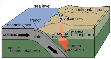
Plate tectonics deals with the processes of plates under the
Earth’s crust moving laterally over the asthenosphere. The
widely common scientist belief is that the Juan De Fuca plate is
moving eastward and subducting under the North American Plate. To
subduct is to move under something. The Juan De Fuca plate is
subducting under the North American plate just off the
Washington/Oregon coast. This subduction zone or where the two
plates meet is called the Cascadia Subduction Zone.
Mount St. Helens is an active volcano in southwest Washington State
and the central feature of the Mount St. Helens National Volcanic
Monument.
Mount St. Helens is a popular climb for both beginning and
experienced mountaineers. Although people are able to climb Mount
St. Helens year-round, late spring through early fall is the most
popular season.
Most climbers use the Monitor Ridge Route from Climbers Bivouac.
This route gains 4,500 feet in five miles to the crater rim at
8,365 feet elevation. Although strenuous, this non-technical climb
is suitable for people in good physical condition who are
comfortable scrambling on steep, rugged terrain. Most climbers
complete the round trip in seven to twelve hours.
While climbing to the crater rim is permitted, entry into the
crater is strictly prohibited.
*Climbing permits are required year-round.
*Each climber must display their own climbing permit.
*Permits are valid for 24 hours starting at midnight for the date
of climb.
*Maximum party size is 12 climbers.
*Access is limited to protect the volcano’s physical and
biological features and processes, and to reduce crowding.
As with any hike take all the necessary precautions i.e. bring your
ten essentials and make sure you tell someone where you’re
going and when you expect to be back. Please use your best
geocaching and hiking judgment when attempting the trail to this
cache, especially during the winter months.
| If you are a Geocacher in the state of Washington, please
join the Washington State Geocaching Association. This is a great
way to get the most out of Geocaching in our region. Simply go to
the WSGA Web
Page for details! |


Additional Hints
(Decrypt)
Ybbx sbe oyhr fbyne cnanyf.
Gur oebamr orapuznex qvfx vf gb gur AJ bs gur Fbyny Cnaryf. vg vf rzorqqrq va gur ebpxf...Vg znl or ohevrq haqre fabj ng pregnva gvzrf bs gur lrne.