Caches that bring you to interesting crosses that have been placed along ancient ways.
This cache is dedicated to families that want to explore this region (the northern Schmida valley) by bike. It leads you in a 10 km circle back to the starting point. This trip partially follows the Riesling bike route and the Radetzkymarsch hike. There are many nice places to rest in the shadows (mainly in the second half of the route) and there are also 2 playgrounds for the kids that you will pass by.
The whole route is over tarmak and does not pose any difficulties to bikes nor to riders (but the last 10 meters to the Cache ;-)
Cacheserie, die zu interessanten Wegkreuzen entlang alter Wege führt.
Dieser Cache ist für radfahrende Familien und führt in einer rund 10 km langen Schleife im nördlichen Schmidatal wieder zum Ausgangspunkt zurück. Der Rundweg folgt teilweise dem Riesling Radweg und der Radetzkymarsch Wanderung. Es gibt zahlreiche sehr schöne Rastplätze (in der 2. Hälfte des Weges) und man kommt auch an 2 Spielplätzen vorbei. Die Strecke ist durchgehend asphaltiert (bis auf die letzten 10 Meter zum Cache ;-)
Enjoy the view!
Genießt die Aussicht!
Parking and Refreshments
N 48° 38.662'
E 015° 55.799'
Leave your car here and get on your bikes
Hier können 2-3 Autos parken und dann geht es weiter mit dem Rad
WP1: Johannes Nepomuk - Jan Nepomucký
N 48° 38.642'
E 015° 55.755'
What does he carry in his hand?
A = numbes of letters in this word
Was hält er in seiner Hand?
A = Anzahl der Buchstaben dieses Wortes
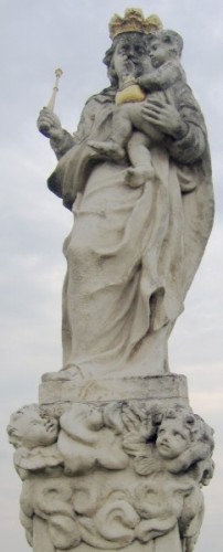
WP2: Maria
N 48° 38.344'
E 015° 55.713'
BCDE = digits of the older date (the one in black)
BCDE = ältere Jahreszahl (die in Schwarz)
WP3: Wegkreuzung
N 48° 38.(B-D) (A+E) E'
E 015° 55.C E (A+E)'
F = number of items the statue holds in its hands
F = Anzahl der Dinge, die die Statue in den Händen hält
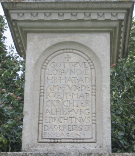
WP4: Ferdinand Kauderer
N 48° 37.A A (E-F-B)'
E 015° 55.(B+C) (A-E-D) (B-D)'
GHIJ = the year Ferdinand Kauderer died
GHIJ = Todesjahr von Ferdinand Kauderer
One number is 0 (not 6)
WP5: Friedhof
N 48° 37.(F-D) I (A-F)'
E 015° 55.H (C-D) (C-A)'
KLMN = year on the cross
KLMN = Jahreszahl am Wegkreuz
Year seems difficult to read: KLMN = 1780
WP6: Halbzeit - Midway
Turn left here
Hier links abbiegen
N 48° 36.(H-L) (J-D) (L-G)'
E 015° 56.(J-A) N (H+D)'
OPQR = year on the front of the cross
OPQR = Jahreszahl an der Front des Kreuzes
Take the little road until its end, then turn left and left again (you may also want to enter the village for some refreshments)
Die kleine Straße weiter bis ans Ende, dann Links und gleich wieder Links (im Ort gibt es Erfrischungsmöglichkeiten)
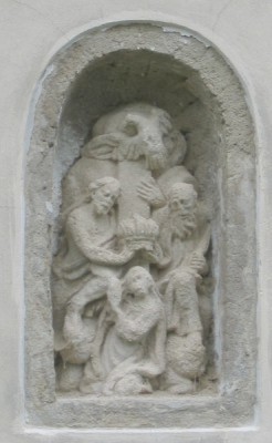
WP7: Figuren in der Kellerwand
N 48° 36.(M-J) (P+F) (Q+D)'
E 015° 56.A R F'
Take a seat and have a break
Hier könnt ihr sitzen und euch erholen
WP8: Holzkreuz
N 48° 36.(P-Q) (P+F) I'
E 015° 56.F L A'
Color of the corpus on the cross?
S = numbes of letters in this word
Welche Farbe hat der Korpus?
S = Anzahl der Buchstaben dieses Wortes
WP9: Wallfahrtskreuz Mariazell
N 48° 36.J (S+A) L'
E 015° 56.(H-P) M C'
TUUV = year at the top of the cross
TUUV = Jahreszahl ganz oben am Kreuz
WP10: Jacob Pendl
N 48° 36.(P+V) V F'
E 015° 56.F U T'
WXYZ = year under the name of Jacob Pendl
WXYZ = Jahreszahl unter Jacob Pendl's Namen
WP11: Pieta
N 48° 37.U Y R'
E 015° 56.(Y-Z) (Z-S) T'
abcd = year of renovation
abcd = Jahreszahl der Renovation
After playground(!) at well turn right and left again
Nach Spielplatz(!) beim Dorfbrunnen Rechts dann wieder Links
WP12: Wegkreuz bei der alten Mühle 1
N 48° 37.d Y T'
E 015° 56.B D G'
WP13: Wegkreuz bei der alten Mühle 2
N 48° 37.X P N'
E 015° 56.K T I'
Continue straight on and you will pass another playground
Immer geradeaus weiter und man kommt wieder an einem Spielplatz vorbei
WP14: St. Florian
N 48° 38.(Y-c) c X'
E015° 56.(d-Q) b R'
efgh = year behind St. Florian
efgh = Jahreszahl hinter St. Florian
Sit down there and do some calculations for the final coordinates
Setzt euch zum Errechnen der Cachekoordinaten
Final Stage: Cache
Cachekoordinaten:
N 48° (a+b+c+d+e+f+g+h-T).(b*c*P)+d+g+A'
E 15° (A+B+C+D+E+F+G+H+I+J+K+L+M+N+O+P-Q).(S*Z*h)-V'
Please close cache container carefully and put back the cover on top of it.
Bitte Cachedose wieder gut verschließen und Deckel aufsetzen.
Return to parking via WP16
Zurück zum Parkplatz via WP16
WP16: Maria
N 48° 38.g d b'
E 015° 55.(Y+D) W b'