 Introduction
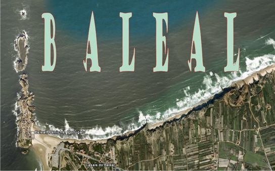
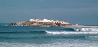
Baleal is a small promontory of rocks resembling a north-pointing finger outcropping east of Peniche. Baleal is made up, from North to South, of Ilhéu de Fora, Ilha das Pombas, Entre Ilha and Baleal.
Baleal is famous for its beach and is a site of weekend sun seekers, surfers and wind surfers from as far afield as Lisbon and its surrounding suburbs.
 Introdução
O Baleal é um pequeno promontório rochoso semelhante a um dedo apontando a norte situado a Este de Peniche. O Baleal é constituido, de Norte para Sul, pelo Ilhéu de Fora, Ilha das Pombas, Entre Ilha e Baleal.
O Baleal é tambem famoso pelas suas praias e é um local previlegiado para a prática de desportos com o surf e wind surf, atraindo praticantes de todo o país.
Geological setting
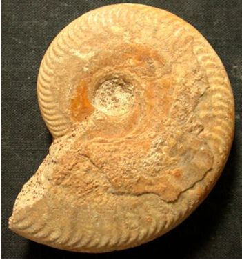
The sequences of rocks outcropping in Baleal are exclusively stratified Jurassic limestones. Detailed dating using fossils place these rocks in the Mid-Jurassic Epoch (175 – 161 Ma) where sequences from the Bajocian (171.6 – 167.7 Ma) to the Bathonian (167.7 – 164.7 Ma) are developed.
Bathonian: The Lower Bathonian outcrops in Baleal and Ilha das Pombas and is made up of compact, stratified limestone. It attains a maximum thickness of 45 m in baleal and 56 m in Ilha das Pombas.
Fauna includes Oppelia fallax GUER., Normannites sp., Cadomites d. linguiferus (D 'ORB.), Parkinsonia sp., Morphoeeras poly morphum (D'ORB.), Ebrayiceras jaetatum S. BUCK., Procerites cf. subprocerus S. BUCK., P. tmetolobus S. BUCK., Siemiradzkia aff. aurigera (OPPEL), Belemnites bessinus D'ORB., Aulacothyris meriani (OPPEL), A. mandelslohi (OPPEL), Terebratula gomesi CHOFF., T. infraoolithica E. DESL., Rhynchonella (Flabellirhynchia) mutans ROTH (França et al., 1960).
Bajocian: Only the upper Bajocian is represented in Baleal and Ilha das Pombas. It is made up of 42 m of marly limestone and compact limestone that are locally oolithic with intercalations of schist.
Fauna includes Oppelia (Oecotraustes) primoeva DE GROSS., O. (O.) cf. genicularis VAAG., O. (o.) cf. umbilicata S. BUCK., Cadomites sp., Parkinsonia gr. depressa (QUENST.), P. aff. crassa ( QUENST.), P. cf. neuffensis (OPP.), Bigotites nicolescoi DE GROSS., B. cf. thevenini NICOL., Perisphinctes cf. perspicuus PARONA, P. sp., Belemnites (Belemnopsis) fusiformis PARK., B. (B.) bessinus D'ORB., Terebratula infraoolithica DESL., Aulacothyris meeriani (OPP.), Rhynchonella (Flabellirhynchia) aff. lotharingica HAAS & PIET., R. (F.) mutans ROTH, R. aff. voultensis OPP., Posidonomya sp., Orthostoma sp., Pseudodiadema (Diplopodia) sp., Cancellophycus sp. (França et al., 1960).
Opelia
Definição Geologica
As formações rochosas do Baleal são exclusivamente formadas por calcários estratificados do Jurássico. Datação detalhada usando fosseis colocam estas rochas no Médio Jurássico (175 – 161 Ma) desenvolvendo-se do periodo Bajociano (171.6 – 167.7 Ma) ao Bathoniano (167.7 – 164.7 Ma) .
Bathoniano: As formações do Baleal e Ilha das Pombas são do Bathoniano Inferior e são constituidas por calcário compacto, estratificado. Atingem a espessura máxima de 45m no Baleal e 56 m na Ilha das Pombas.
A Fauna inclui Oppelia fallax GUER., Normannites sp., Cadomites d. linguiferus (D 'ORB.), Parkinsonia sp., Morphoeeras poly morphum (D'ORB.), Ebrayiceras jaetatum S. BUCK., Procerites cf. subprocerus S. BUCK., P. tmetolobus S. BUCK., Siemiradzkia aff. aurigera (OPPEL), Belemnites bessinus D'ORB., Aulacothyris meriani (OPPEL), A. mandelslohi (OPPEL), Terebratula gomesi CHOFF., T. infraoolithica E. DESL., Rhynchonella (Flabellirhynchia) mutans ROTH (França et al., 1960).
Bajociano: Apenas o Bajociano superior está representado no Baleal e na Ilha das Pombas. É composto por 42 m de calcário margoso e calcário compacto, localmente oolítico com intercalação de xisto.
A Fauna inclui Oppelia (Oecotraustes) primoeva DE GROSS., O. (O.) cf. genicularis VAAG., O. (o.) cf. umbilicata S. BUCK., Cadomites sp., Parkinsonia gr. depressa (QUENST.), P. aff. crassa ( QUENST.), P. cf. neuffensis (OPP.), Bigotites nicolescoi DE GROSS., B. cf. thevenini NICOL., Perisphinctes cf. perspicuus PARONA, P. sp., Belemnites (Belemnopsis) fusiformis PARK., B. (B.) bessinus D'ORB., Terebratula infraoolithica DESL., Aulacothyris meeriani (OPP.), Rhynchonella (Flabellirhynchia) aff. lotharingica HAAS & PIET., R. (F.) mutans ROTH, R. aff. voultensis OPP., Posidonomya sp., Orthostoma sp., Pseudodiadema (Diplopodia) sp., Cancellophycus sp. (França et al., 1960).
The earthcache
The coordinates will take you to the outcropping Bajocian/Bathonian limestones. Here you are faced with stratified, compact sediments and where you have to answer three questions in order to be able to log the cache.
1- What´s the predominantcolours of the sediments?
a- light grey
b- whitish
c- greenish
d- bluish-grey
2- Estimate the angle of dip of the strata with the horizontal.
a- 5-10º
b- 10-20º
c- 20-30º
d- 30-50º
3- Estimate the average thickness of the beds
a- 10-20 cm
b- 20-50 cm
c- > 70 cm
E-mail me the answers before logging the cache. Have fun.
A earthcache
As coordinadas levá-lo-ão a um promontório composto por calcários do Bajociano/Bathoniano. Aqui ir-se-á deparar com sedimentos compactos e estratificados e terá que responder ás 3 questões seguintes para puder reclamar o found da cache.
1- Qual a cor predominante dos sedimentos?
a- Cinzento claro
b- Esbranquiçados
c- Esverdeados
d- Cinzento-Azulados
2- Estime o angulo dos referidos estratos.
a- 5-10º
b- 10-20º
c- 20-30º
d- 30-50º
3- Estime a espessura média das camadas
a- 10-20 cm
b- 20-50 cm
c- > 70 cm
Enviem-me as respostas por E-mail antes de efectuar o log. Divirtam-se.
França, J. C., Zbyszewski, G., Almeida, F. M. de, 1960. Notícia explicativa da Folha 26-C (PENICHE), Serviços Geológicos de Portugal, 33p.
Zbyszewski, G. et al., 1960. Carta Geológica de Portugal 26-C (Peniche). Serviços Geológicos de Portugal.