[Deutsch] Versuchen
Sie klicken hier.
[English]
The Tatzelwurm
(also Tatzlwurm) is a waterfall in the Bavarian Alps.
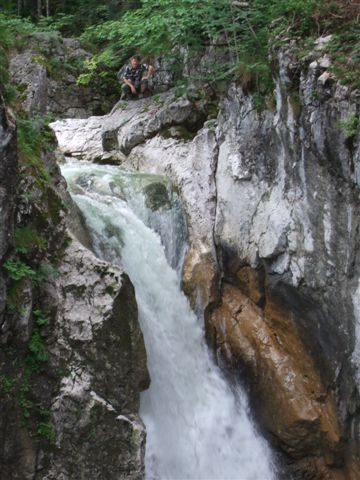
It is located in Mangfall mountains west of Oberaudorf in a
westerly direction to Bayrischzell. Water is rolling-down in the
deep gorge over two rocky stages a total of 95 m in only a few
metres, through which the masses of water surge in the Inn. Its
granitt riverbed as hard material has played main role in a
formation of the waterfall. Erosion effect is not so drastic and
quick as in a case of soft subsoil. Alterations are minimal, only
slow smoothing occasioned by a motion of water and small pebbles
leads in occurrance of depressions (sometimes called devils
eyes).
The waterfall received its name according to the Tatzelworm
myth, a legend for its formation and origin than the forecasts are:
You can hear the thunder of falling water and see the rising fog
already from a distance, but the canyon and the waterfall itself
can be seen only when you stay directly on it. If you are careless
in this area, you can plunge into the gorge and so "of Tatzelworm
devoured".
Today an access to the beautiful waterfall is with a developed
road and there are two bridges which are crossing the waterfall,
the upper and the lower one.
A waterfall is usually a geological formation resulting from
water, often in the form of a stream, flowing over an
erosion-resistant rock formation that forms a sudden break in
elevation or nickpoint.
Some waterfalls form in mountain environments where the erosive
water force is high and stream courses may be subject to sudden and
catastrophic change. In such cases, the waterfall may not be the
end product of many years of water action over a region, but rather
the result of relatively sudden geological processes such as
landslides, faults or volcanic action.
Typically, a river flows over a large step in the rocks which
may have been formed by a fault line. Over a period of years, the
edges of this shelf will gradually break away and the waterfall
will steadily retreat upstream, creating a gorge of recession.
Often, the rock stratum just below the more resistant shelf will be
of a softer type, meaning undercutting, due to splashback, will
occur here to form a shallow cave-like formation known as a rock
shelter or plunge pool under and behind the waterfall. Eventually,
the outcropping, more resistant cap rock will collapse under
pressure to add blocks of rock to the base of the waterfall. These
blocks of rock are then broken down into smaller boulders by
attrition as they collide with each other, and they also erode the
base of the waterfall by abrasion, creating a deep plunge pool or
gorge.
Streams become wider and more shallow just above waterfalls due
to flowing over the rock shelf, and there is usually a deep pool
just below the waterfall because of the kinetic energy of the water
hitting the bottom.
Waterfalls are grouped into 10 broad classes based on the
average volume of water present on the fall using a logarithmic
scale:
* Block: Water descends from a relatively wide stream or
river.
* Cascade: Water descends a series of rock steps.
* Cataract: A large waterfall.
* Fan: Water spreads horizontally as it descends while remaining
in contact with bedrock.
* Horsetail: Descending water maintains some contact with
bedrock.
* Plunge: Water descends vertically, losing contact with the
bedrock surface.
* Punchbowl: Water descends in a constricted form, then spreads
out in a wider pool.
* Segmented: Distinctly separate flows of water form as it
descends.
* Tiered:Water drops in a series of distinct steps or falls.
* Multi-step: A series of waterfalls one after another of roughly
the same size each with its own sunken plunge pool.
To log this earthcache find, you must fulfil the following
requirements:
1. In your log entry, upload a picture of yourself (or your GPS if
alone) near waterfall or on bridge above it.
2. Ascertain and send us by e-mail:
a) the class of Tatzelwurm waterfall
b) the elevation from lover brigge to upper bridge. Use your GPS to
measure difference in altitude. If you have no GPS, try guess. NOT
HAVE TO BE ACCURATE.
A photography of you on the lower bridge from the upper bridge
are welcome.
Please note that
any logs that do not comply with the aforementioned requirements
will be deleted.