The marsh was formed in 1916-17 when the Alaska Railroad embankment was constructed. The embankment limited the inflow of Cook Inlet waters and the outflow of fresh water to a single bridge at Rabbit Creek. The holes excavated to extract fill for the embankment became the deeper ponds in Potter Marsh. The construction of the embankment impacted existing tidal habitat; but, by impounding freshwater and enhancing habitat diversity, the marsh has become an example of wetlands mitigation in the Anchorage area.

The impounded freshwater comes from three sources: Rabbit Creek, Little Rabbit Creek, and Little Survival Creek. Rabbit Creek originates from Rabbit Lake, located about ten creek miles east of the marsh, while Little Rabbit Creek originates from the upper reaches of Bear Valley about six creek miles east of the marsh. Both Rabbit Creeks flow into the northern end of the marsh, combine, and flow under the old board walk to the culvert under the Seward Highway. Little Survival Creek begins on the hillside above Goldenview Drive and flows about two miles to the southern end of the marsh where its waters are diverted to the north by the Seward Highway embankment to the Seward Highway culvert.
Completing this cache will take you to the locations where each of these creeks crosses under the Old Seward Highway and flows toward the marsh. You will need to note the relative flows of the streams, look to the Chugach Mountain foothills to determine upstream factors that can impact water quality and sedimentation of the marsh, and learn the surprising fact about which of the streams provides the largest benefit to the marsh. The coordinates for the cache place you on the boardwalk near where Rabbit Creek enters the marsh.
You may access the marsh from several locations. The original (built in 1985 and 1989) 1,550-foot boardwalk with interpretive signs provides access to the northern part of the marsh parallels the Seward Highway. A new 1100-foot boardwalk opened in early July 2008 and pushes east into the marsh to provide more wildlife viewing possibilities away from the Seward Highway. To access the boardwalks, follow the brown highway sign on the Seward Highway at mile 117.4, (just past the Rabbit Creek Road exit when southbound on the Seward Highway) about ten miles south of downtown Anchorage. A small highway pullout at the southern end of the marsh allows for viewing and photography from a vehicle and the "POTTER" benchmark to log. Parking and wildlife viewing are also available at the base of Potter Valley Road. One may circumnavigate the marsh by making a clockwise loop (for easier access to pullouts and parking) by driving north on the Seward Highway to the Rabbit Creek exit. Turn left at the top of the exit ramp and head east (toward the mountains) on Rabbit Creek Road/Old Seward Highway and then turn right (south) on Old Seward Highway. Follow Old Seward Highway to Potter Valley Road and turn right again to complete the loop back to the Seward Highway.
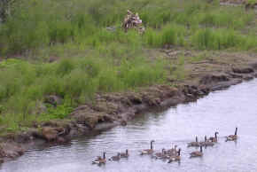
In addition to learning opportunities about the local hydrology, there are lots of flora and fauna viewing opportunities at the marsh. Spruce, cottonwoods, and alders border the north and east sides of the marsh and grasses and wetlands border the south and west sides of the marsh. The marsh hosts the greatest number of birds between late April and the end of May. Bald eagles, northern harriers, yellowlegs, Arctic terns, pintails, Canada geese, red-necked grebes, and Pacific loons stay through the summer. Muskrats and moose frequent the marsh year-round; in May and June, look for them in the evenings as they forage on the new green growth. From June through September, three species of salmon (chinook (king), coho (silver), and pink) return to spawn in Rabbit Creek. Dolly varden trout, round white fish, sticklebacks, and sculpins are present, but you can't fish here. Wood frogs (yes, amphibians in Alaska!) are also present in the marsh. In winter, skiers and snowshoers can follow the tracks of resident snowshoe hares, coyotes, beavers, weasels, mink, voles, and shrews. Ice skaters will find “pushups,” piles of sedges stored by muskrats for winter food.
This is an EarthCache - without a container or logbook - where you'll document your observations and understanding via email and a posted photograph to earn credit for this cache. Logs which do not conform to these requirements will be deleted, as this cache requires a demonstrated acquisition of knowledge about the hydrology of Potter Marsh. Read all the requirements for completing this cache before you visit the marsh, and equip yourself with the necessary tools (including a camera).
To complete this earthcache, e-mail the answers of the following questions to the Ladybug Kids. Make sure your log includes how many people were in your group and don't put answers to the questions in your online log!
1. View each of the three major sources of fresh water flowing into Potter Marsh (Rabbit Creek, Little Rabbit Creek, and Little Survival Creek, waypoints provided). List the streams in order from greatest to lowest volumetric flow. Provide an explanation of why the flows are different.
2. Why does the lowest flow stream provides the biggest benefit to the marsh (which streams are still channelized and which one floods the marsh)? (Hint: look at a topographic map, look at a GoogleEarth image, or read the "Hydrology and Water Quality" section of Reference #2.)
3. Potter Marsh is filling with sediment and will eventually need to be selectively dredged. From the listed cache coordinates, look east toward the Chugach Mountains. Identify and list the possible source(s) of sedimentation and watershed impacts that you see.
4. Optional - to earn "extra credit," post a photograph of yourself with your GPS at your favorite location of the marsh with your log.
References:
1. Alaska Department of Fish and Game - Division of Wildlife Conservation, Potter Marsh website.
2. Alaska Department of Fish and Game, “Anchorage Coastal Wildlife Refuge Management Plan,” Anchorage, Alaska, February 1991.
3. "Uncertain Future for Potter Marsh," Anchorage Daily News, Melissa DeVaughn, September 18, 2007.
The Geological Society of America (GSA) EarthCache Project - Learn about the EarthCache Master Program and earn Bronze/Silver/Gold/Platinum status, with an EarthCache Master Pin awarded at each level!
|

|
Current Anchorage Weather

|

|