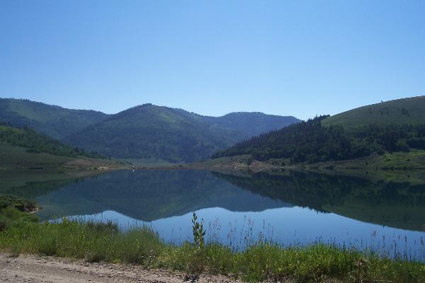
At this cache site, you will be able to see part of these
wetlands. The valley is rich with wetland areas. If you are driving
south, you have already come thru most of the wetland area seen
from the road. But if you are traveling north, this site is just
the beginning of the wetlands you will see. For a real look at the
wetlands, you'll have to leave the road, hike the trails, and
explore the area around you. You won't have to go far from the road
to find these rich wetland areas off the road. One of our favorite
areas, is about 1 mile south of you at Potter's Ponds.
To log your visit you must:
1. Go to the posted coords
2. Read the sign and answer the following questions
a. Why do you think that there is such a high percentage of
wetlands in this area?
b. Wetlands provide food, shelter, and water for what percentage of
Utah’s wildlife?
c. What percentage of threatened and endangered species live ONLY
in wetlands?
3. The sign explains that horseback riding, cycling, and driving
through wetlands can destroy this important habitat, so what is the
trailhead at the posted coords? And how far is East Mountain
(Highpoint for Emery County, Utah) from this point?
4. What type of wetland is before you?
5. Describe the wetland on the day of your visit. How much water,
wildlife, etc.?
6. OPTIONAL: Take a photo of the area and post it with your
log.
What is a wetland?
From Wikipedia, a wetland is an area of land consisting of soil
that is saturated with moisture, such as a swamp, marsh, or
bog.
As defined in terms of physical geography, a wetland is an
environment "at the interface between truly terrestrial ecosystems
and aquatic systems making them inherently different from each
other yet highly dependent on both". In essence, wetlands are
ecotones. Wetlands often host considerable biodiversity and
endemism.
According to the sign at the coords, wetlands filter runoff from
higher land before it reaches open water, trapping sedimant and
contaminants.
Wetlands are natural sponges that trap and slowly release
surface water, preventing flooding.
Wetlands are among the most productive ecosystems in the world,
comparable to rain forests and coral reefs.
Wetlands provide food, shelter and water for wildlife. Many
birds species feed, nest, and raise their young in wetlands.
Wetlands serve as critical habitat for many species of amphibians
and reptiles.
Characteristics
Soils
Wetlands are found under a wide range of hydrological
conditions, but at least some of the time water saturates the soil.
The result is a hydric soil, one characterized by an absence of
free oxygen some or all of the time, and therefore called a
"reducing environment."
Vegetation
Plants (called hydrophytes or just wetland plants) specifically
adapted to the reducing conditions presented by such soils can
survive in wetlands, whereas species intolerant of the absence of
soil oxygen (called "upland" plants) cannot survive. Adaptations to
low soil oxygen characterize many wetland species.
There are many types of vegetation in wetlands. There are plants
such as cattails, bulrushes, sedges, arrowhead, water lilies, blue
flag, and floaters like common duckweed. Pondweed is also another
type of plant that grows in wetlands, but it is not easily seen.
Peatland can be dominated by red maple, silver maple, and elm
trees. Some types of trees in peatland can exhibit lower trunks and
roots that have adapted to the wet surroundings by forming
buttresses,like the cypress, enlarged root bases to better support
the trees in the mucky soil. Trees can also form knees, raised
roots that allow for gas exchange. Swamps can also have whitecedar,
tamarack, and white pine. Below the canopy, there are often limited
amounts of shrubs such as speckled alder, Winterberry, and sweet
gale.
Mangroves are a species of plant which typically thrive in
coastal wetlands (called marine or estuarine environments). They
are a special tree taxon that can survive in salty wetland water.
Mangroves also provide the base for the wetland food chain. They
are the producers in the wetland environment. Because mangroves add
sulfur to the wetlands, it makes the water more acidic, therefore
allowing decomposed matter in the water to biodegrade faster than
it normally would, which in turn, provides more food for the
organisms in the wetland ecosystem.
Hydrology
Generally, the hydrology of a wetland is such that the area is
permanently or periodically inundated or saturated at the soil
surface for a period of time during the growing season. The
presence (or absence)of water is not necessarily a good method for
identifying wetlands because the amount of water generally
fluctuates depending on such things as rainfall patterns, snow
melt, dry seasons, longer droughts, and tidal patterns. Often the
same wetland can appear to be an open body of water sometimes and a
dry field at other times because of significant fluctuations in
water levels. The three water sources that contribute to wetlands
are:
• precipitation falling within the wetland
• groundwater moving up or out from the subsurface of the
wetland
• surface flow from the surrounding watershed or nearby water
bodies (lakes, streams, oceans, etc.)
Location determines which of these sources will be contributing
water to a wetland.
Topography
Generally, wetlands are located within topographic features that
are lower in elevation that the surrounding landscape such as
depressions, valleys, and flat areas. Topography plays an important
role in determining the size and shape of a wetland by controlling
where the water goes and how long it stays there.
Classification
Below are terms used for various types of wetlands:
• A bog or muskeg is acidic peat land (peat bog).
• A moor was originally the same as a bog but has come to be
associated with this soil type on hill-tops.
• A moss is a raised bog in Scotland
• A fen is a freshwater peat land with chemically basic (which
roughly means alkaline) ground water. This means that it contains a
moderate or high proportion of hydroxyl ions (pH value greater than
7).
• A carr is a fen which has developed to the point where it
supports trees. It is a European term, mainly applied in the north
of the UK.
• A freshwater marsh's main feature is its openness, with only
low-growing or "emergent" plants. It may feature grasses, rushes,
reeds, typhas, sedges, and other herbaceous plants (possibly with
low-growing woody plants) in a context of shallow water. It is an
open form of fen.
• A vernal pool ( or ephemeral) is a shallow, freshwater pond
that is seasonal, having water during rainy months and drying up
completely during the remainder of the year. One distinctive
characteristic is the lack of fish species in the pool.
• A coastal salt marsh may be associated with estuaries and
along waterways between coastal barrier islands and the inner
coast. The plants may extend from reed in mildly brackish water to
salicornia on otherwise bare marine mud. It may be converted to
human use as pasture (salting) or for salt production
(saltern).
• A swamp is wetland with more open water surface and deeper
water than a marsh. In North America, it is used for wetlands
dominated by trees and woody bushes rather than grasses and low
herbs, but this distinction does not necessarily apply in other
areas, for instance in Africa where swamps may be dominated by
papyrus.
• A dambo is a shallow, grass-covered depression of the
central and southern African plateau which is waterlogged in the
rainy season and usually forms the headwaters of a stream or river.
It is marshy at the edges and at the headwater but maybe swampy in
the centre and downstream.
• A mangrove swamp or mangal is a salt or brackish water
environment dominated by the mangrove species of tree, such as
Sonneratia.
• A paperbark wetland is a fresh or brackish water environment
dominated by the Melaleuca tree.
• A bayou or slough is a southern United States terms for a
creek amongst swamp. In an Indian mangrove swamp, it would be
called a creek. • A constructed wetland is artificially
contrived wetland, intended to absorb flash floods, clean sewage,
enhance wildlife or for some other human reason.
• A pocosin is a bog-like wetland dominated by fire-adapted
shrubs and trees, found mainly in the southeastern United States on
the Atlantic Coastal Plain.
• Seasonally flooded basins or flats.
• Inland fresh meadows.
• Inland shallow fresh water.
The U.S. Fish and Wildlife Service's National Wetlands Inventory
(NWI) produces and provides information on the characteristics,
extent, and status of U.S. wetlands and deepwater habitats and
other wildlife habitats. The NWI also produces periodic reports on
the status and trends of wetlands in the conterminous U.S. The NWI
website includes a Wetlands Mapper.
Hydrogeomorphic classes
The Hydrogeomorphic (HGM) Approach is a system developed by the
United States Army Corps of Engineers to classify all wetlands
based on three factors that influence how they function: position
in the landscape (geomorphic setting), water source (hydrology),
and the flow and fluctuation of the water once in the wetland
(hydrodynamics). There are seven classes (types) of wetlands in
this system:
• riverine
• depressional
• slope
• mineral soil flats
• organic soil flats
• estuarine fringe
• lacustrine fringe