The cache should be approached on foot as there is no parking on the bridge itself (free street parking nearby on both sides of the river). Please be aware that there is a toll on the bridge for motor vehicles. Pedestrians and cyclists may cross for free. The bridge is also wheelchair accessible.
Once you've found the cache I would really recommend a visit to the suspension bridge visitor centre. You can also get more details about the bridge here: Clifton Suspension Bridge
The Legend:
There are a couple of different medieval legends which attempt to explain how the Avon Gorge was created. One version is that a giant called Vincent and his brother Goram both wanted to marry a beautiful woman called Avona. Not being able to choose between them, Avona challenged the brothers to drain a lake which lay over Bristol. Vincent chose to cut a channel through the limestone hills near Clifton, while Goram began to cut a channel through Henbury. Unfortunately for Goram, he drank one too many beers while he was working and fell asleep, leaving Vincent to finish his channel first, drain the lake and so win Avona.
When Goram woke up, he was so distraught at having lost out to his brother, he stamped his foot in anger and in the process created another nearby geological feature in Henbury Gorge called the Giant’s Footprint. Goram then drowned himself in the Severn Estuary. The islands of Steep Holm and Flat Holm are supposedly the remains of his head and shoulder.
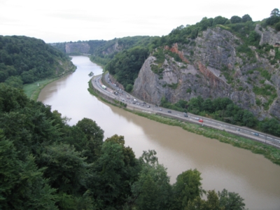
The Geology:
Although the legend makes a pretty story, in reality the gorge was formed by the river Avon which over thousands of years has eroded the limestone creating the spectacular gorge that you see today. The gorge runs 1.5 miles from here towards the Severn estuary where the river eventually meets the sea.
Fossils show that the rock here was laid down during the Carboniferous period 350 million years ago. Firstly a layer of sandstone was deposited, followed by limestone sediments. The cliffs you see today are predominantly of limestone.
Geologists have often pondered why the river Avon cut through the limestone ridge, rather than taking the more natural route to the sea through Aston Vale towards Weston-Super-Mare. The commonly accepted explanation is that during the ice age, Aston Vale was blocked by a glacier, forcing the river to take this alternative route.
To Claim This Cache:
After you log your find, please email the answers to the following questions to my profile:
How wide is the Avon Gorge at this point?
How high are you above sea level?
(Tip: There are no info boards to answer these questions - instead why not use your GPS to find the answers?)
In keeping with the recent changes to Earthcache rules, photographs are now optional and so I have removed this requirement from the cache. I do love to see your photos though, so I hope you will all keep posting them to the cache page.
Thanks for taking the time to visit this Earthcache and I hope you enjoy your visit.