Welcome to Pugwash,
a small village known for
peace, pewter, and (perhaps most
importantly) salt!
Did you know Pugwash sits on top of a salt deposit measring almost
460 metres thick? [1] This salt deposit is a significant geological
resource to Atlantic Canada. The listed coordinates for this
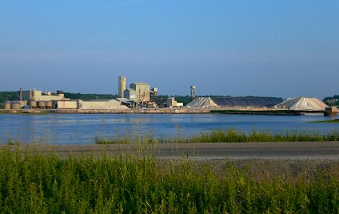
earthcache should put you at Pugwash's Visitor Information Centre,
with an excellent view of The Canadian Salt Company's Pugwash mine.
If you're lucky enough, the visitor's centre may be open to explore
and learn more about the mine and the village of Pugwash.
Common salt is a basic need to human survival and a fundamental
material in our industrial society. As well as the familiar uses of
salt in cooking, salt is also used in many industrial applications.
In regions with cold climates, such as Atlantic Canada, large
quantities of rock salt are used to help clear the highways of ice
and snow during the winter. Common salt, or halite, is typically
found in one of three forms: underground in undisturbed bedded
deposits, in underground salt domes, and in the ocean as natural
brines. [2][3]
Nova Scotia's large underground salt deposits are found in a
rock unit called the Windsor group. These deposits were formed 335
to 350 million years ago during the early Carboniferous Period. At
that time, most of the Maritime Basin was covered by a body of
water called the Windsor Sea (Fig. 1). The hot, dry climate of the
Carboniferous Period caused evaporation of water in the sea, making
it extremely "salty". As the water evaporated, salt and other
minerals precipitated from the water and were deposited on the sea
bed. The sea level rose and fell periodically during the 15 million
years the Windsor Sea existed leaving behind layer after layer of
mineral deposits. These deposits, known as evaporite deposits, make
up the Windsor rock group. The Windsor group is approximately 1000
metres thick and is a major source of industrial minerals and base
metals mined in Atlantic Canada today. [4][5][6]
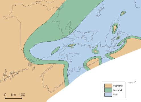
Figure 1: Windsor Sea during the early Carboniferous Period.
[5]
Over time, the salt deposits of the Windsor Group were covered
with sediment and became buried. Since the density of salt is
generally less than that of its surrounding material, it has a
tendency to move upward toward the surface forming large bulbous
domes (Fig. 2) as it rises. This explains why salt deposits, like
the one in Pugwash, tend to be found in a "dome" shape and why the
salt can sometimes be found quite close to the surface. [7]
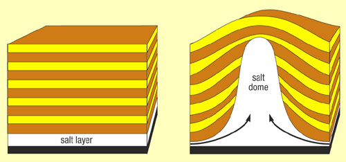
Figure 2: A typical salt dome formation. [8]
Salt was discovered accidentally in Pugwash, when drilling for
water at a lobster factory in 1953. Not long after, The Canadian
Salt Company hoisted its first load of salt in 1959. Mining at the
Pugwash mine currently takes place up to 350 metres underground by
room and pillar method, where drifts (tunnels) 9 metres high by 17
metres wide are separated by 23 by 23 metre supporting pillars. The
salt ore is removed by blasting and scaling the rock face,
advancing 4 metres at a time. The rock salt is refined at the
surface in a mill by crushing and screening. The fines are then
processed through an evaporation plant to produce pure, fine salt.
Most of the mine runs under the Pugwash River, with some under
solid ground (Fig. 3). The mine produces over 1 million tonnes of
salt each year, 90% of which is rock salt used for ice and snow
removal on highways. [2][9]

Figure 3: Location map of the 630 foot mining level of the
Pugwash mine. [10]
In order to log this
earthcache, please take a photo of your group with the
salt mine in the background at the listed coordinates and post it
with your log and send an email to the cache owners with the
answers to the following questions:
- How many stockpiles are currently visible at the mine from the
listed coordinates?
- Travel to N45° 50.771' W63° 39.721' or N45° 50.722' W63°
38.911' (your choice). These are the approximate locations of the
end of an underground mine drift (see Fig. 3). What is located on
the surface above the mine at this point?
Any logs not meeting these requirements will be
deleted.
References:
[1]
http://en.wikipedia.org/wiki/Pugwash,_Nova_Scotia
[2] http://www.gov.ns.ca/natr/meb/ic/ic19.htm
[3] http://en.wikipedia.org/wiki/Sodium_chloride
[4] http://www.gov.ns.ca/NATR/MEB/ic/ic33.htm
[5] http://earthnet-geonet.ca/vft/ns/basin_e.php
[6] http://museum.gov.ns.ca/mnh/nature/nhns/t2/t2-4.pdf
[7] http://en.wikipedia.org/wiki/Salt_dome
[8]http://www.creationscience.com/onlinebook/HydroplateOverview7.html
[9] http://www.pugwashvillage.com/industry.html
[10]
http://www.gov.ns.ca/natr/MEB/data/mapgallery/map/htm/map_1990-003.htm
 |
Want to be further rewarded for visiting EarthCache
sites around our planet? Then why not become involved
in the exciting new EarthCache Masters
program. Just visit three or more EarthCache sites (view guidelines) to start being sent
special collectable EarthCache Masters pins. There are four levels
to strive to own — Bronze, Silver, Gold and Platinum.
Its free and easy to participate! Come join in the fun.
|
To visit an EarthCache near you, click on the EarthCache
Listings, and find a site that interests you. |
 |