Deception Pass Earthcache EarthCache
Deception Pass Earthcache
-
Difficulty:
-

-
Terrain:
-

Size:  (other)
Please note Use of geocaching.com services is subject to the terms and conditions
in our disclaimer.
Located in Deception Pass State Park—Washington State’s most popular state park receiving over three million visitors per year.

History
-----------------------------------------------------------------------------------------------------------
In 1792, a British expedition to the Pacific Northwest led by Captain George Vancouver sailed out into our little corner of the world. During their voyage of discovery, a group of sailors (led by Vancouver's First Mate, Joseph Whidbey) sailed through a narrow waterway in the northern region of the Puget Sound. This area, which was originally chartered by Spanish explorers in 1790, was thought to only be a narrow bay. Further exploration by the British concluded the narrow channel was actually a strait between the mainland and Whidbey Island (which was named after Joseph Whidbey). This misconception resulted in the naming of the passage as “Deception Pass”. Today, we can still see what these European explorers saw when they first laid eyes on this dramatic landscape--rugged cliffs, old-growth forests, and beguiling bluish-green waters.
Formation
-----------------------------------------------------------------------------------------------------------
Now imagine yourself standing here 12,000 years ago during the last major ice age. In this particular area, glacial ice was nearly a mile thick and extended as far south as where Olympia is today. Known as the Vashon Ice Sheet, this glacier moved from the north into lower latitudes and helped shape the landscape of the entire Puget Sound region. As the ice sheet moved over what is now Deception Pass, it carved out a deep groove (wedge) along a fault line—a fracture in the rock—that runs through the pass. This area of weakness in the rock is why the wedge is located here. As the climate began to get warmer and the ice receded northward, the wedge became exposed, filled in with water, and became the waterway that we see today.
Tidal Currents
-----------------------------------------------------------------------------------------------------------
Although Deception Pass may be famous for its natural beauty, it is also well known for its powerful and sometimes deadly currents. Capable of reaching speeds between 8-12 knots, the tidal current that runs through the pass forces nearly two million gallons of water flow through the pass per second. That’s more than 50 times the average flow of all the rivers emptying into Puget Sound. These torrents are created by the changes in tidal flow through the narrow channel. Gravitational attraction from the sun and moon are what cause a rising tide (flood tide = landward) and a falling tide (ebb tide = seaward). The transition between flood and ebb tide is known as slack tide. It is during this time that there is no tidal current and the waters are relatively calm. With two flood tides and two ebb tides throughout the day, the pass experiences four slack tides every 24 tidal hours. There are three tidal patterns which involve daily ebb and flood tides. These patterns vary depending on location, each occurring during a 24-hour period.
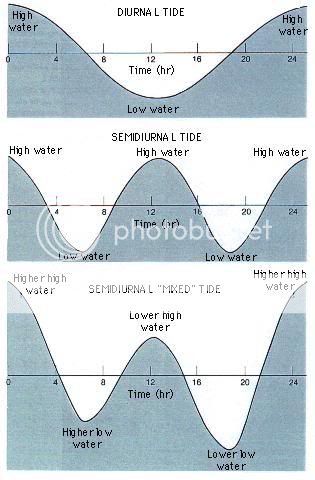
- A diurnal pattern consists of one flood tide and one ebb tide.
- A semidiurnal pattern consists of two flood tides and two ebb tides, with each high and low tide reaching about the same height as each other.
- The type of pattern that Deception Pass undergoes is known as a semidiurnal mixed tide, in which the high tides regularly reach different heights and the low tides drop regularly to different levels.
___________________________________________________________________________________________________________
Logging Requirements:
- Sending Answers via E-Mail
- For the first part of logging this EarthCache, the posted coordinates will bring you to a plaque on Pass Island. How deep is the pass in fathoms? How fast do the currents move through the pass in knots?
- Post in Your Log
- Now, walk out onto the bridge and observe the current flowing nearly 200 feet below where you are standing. Is the tide a flood, ebb, or slack tide? Share your answer and the time of day you made this estimate.
While You're Here:
After visiting this EarthCache, I highly recommend exploring other areas of the park. There are trails that lead down to the beach from the bridge as well as trails leading up to Goose Rock. On the Fidalgo Island side, some key features include Rosario Beach, Bowman Bay, and Lighthouse Point. Remember to stay on the main trails and respect the environment.
If you really have the time, you can even take a guided tour of the park. Have fun!
***Congrats to HOSS1953 for FTF!***
Sources:
- http://en.wikipedia.org/wiki/Deception_Pass
- http://community.seattletimes.nwsource.com/archive/?date=20020729&slug=deception29m
- http://www.parks.wa.gov/parkpage.asp?selectedpark=deception+pass
- http://www.marinemet.com/marinemet_html/wwr249.gif
- An Introduction to the World's Ocean's by Keith A. Syerdrup & Virginia Armbrust
 |
- The geocache may be placed on Washington State Parks and Recreation Commission managed property only by written permission from the Washington State Parks and Recreation Commission.
- The following items shall not be placed in the geocache: Food items; illegal substances; medications; personal hygiene products, pornographic materials; inappropriate, offensive, or hazardous materials or weapons of any type. Log books are required for each cache and are to be provided by the owner of the cache.
- It is the visitor’s responsibility to orient themselves with policies and rules pertaining to State Parks areas.
- Report any incident, problem, or violation to State Parks staff.
|
Additional Hints
(Decrypt)
Fgnegf jvgu n "O" raqf jvgu "evqtr". :) Vg'f ovt naq terra!